File:Black Map, Christchurch (12485843915).jpg
Original file (1,334 × 1,648 pixels, file size: 1.39 MB, MIME type: image/jpeg)
Captions
Captions
Summary[edit]
.jpg&action=edit§ion=1)
| Description |
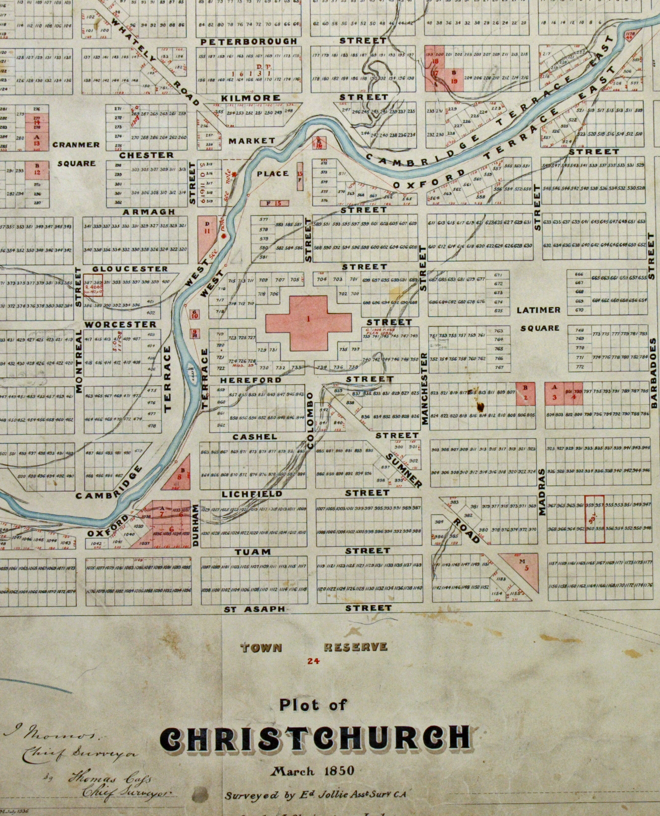
On 22 February 2011 at 12.51pm a magnitude 6.3 earthquake struck Canterbury causing widespread damage to Christchurch city and 185 fatalities. Much of the CBD was destroyed and many significant historic buildings were lost in the event. In the aftermath of the earthquake observers noted that damage in the central city sometimes seemed to follow the lines of old water courses and streams, as shown on the earliest maps of the town. This document is an 1879 copy of an 1850 survey map of central Christchurch, also known as the ‘Black Map’. The name comes from a series of early survey maps of Canterbury which, perhaps fittingly for the region, were referred to as ‘red’ and ‘black’ maps. These maps showed the extent of wetlands and the locations of rivers and streams before they were modified during European settlement of the area. As the city recovered after the 2011 earthquake, renewed interest was shown in such early maps of the settlement, particularly any showing the nature of the land on which it was established. This map, and the original it was based on, can be viewed in our Christchurch reading room. CAYN 23142 CH1031/179 Black Map 273. archway.archives.govt.nz/ViewFullItem.do?code=22668198 And on our online exhibition: Settlers, squatters and surveyors: shaping the Canterbury Settlement 1849-1851. archives.govt.nz/gallery/v/Online+Regional+Exhibitions/Ch... For updates on our On This Day series and news from Archives New Zealand, follow us on Twitter twitter.com/ArchivesNZ Material from Archives New Zealand |
| Date | |
| Source | Black Map, Christchurch |
| Author | Archives New Zealand from New Zealand |
Licensing[edit]
.jpg&action=edit§ion=2)
- You are free:
- to share – to copy, distribute and transmit the work
- to remix – to adapt the work
- Under the following conditions:
- attribution – You must give appropriate credit, provide a link to the license, and indicate if changes were made. You may do so in any reasonable manner, but not in any way that suggests the licensor endorses you or your use.
- share alike – If you remix, transform, or build upon the material, you must distribute your contributions under the same or compatible license as the original.
| This image was originally posted to Flickr by Archives New Zealand at https://flickr.com/photos/35759981@N08/12485843915. It was reviewed on 8 September 2016 by FlickreviewR and was confirmed to be licensed under the terms of the cc-by-sa-2.0. |
File history
Click on a date/time to view the file as it appeared at that time.
| Date/Time | Thumbnail | Dimensions | User | Comment | |
|---|---|---|---|---|---|
| current | 21:37, 8 September 2016 | | 1,334 × 1,648 (1.39 MB) | Vanished Account Byeznhpyxeuztibuo (talk | contribs) | Transferred from Flickr via Flickr2Commons |
You cannot overwrite this file.
File usage on Commons
There are no pages that use this file.
.jpg&oldid=829500601)