File:Bosnia and Herzegovina location map.svg
Aller à la navigation
Aller à la recherche

Taille de cet aperçu PNG pour ce fichier SVG : 628 × 599 pixels. Autres résolutions : 252 × 240 pixels | 503 × 480 pixels | 805 × 768 pixels | 1 074 × 1 024 pixels | 2 147 × 2 048 pixels | 1 063 × 1 014 pixels.
Fichier d’origine (Fichier SVG, nominalement de 1 063 × 1 014 pixels, taille : 141 kio)
Légendes
Légendes
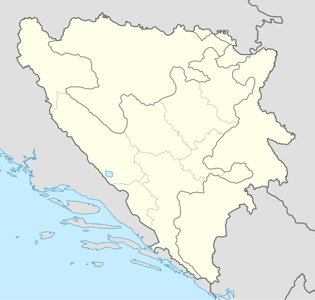
Carte géographique de Bosnie-Herzégovine
Description[modifier]
| Description |
Deutsch: Positionskarte von Bosnien und Herzegowina
Quadratische Plattkarte, N-S-Streckung 140 %. Geographische Begrenzung der Karte:
English: Location map of Bosnia and Herzegovina
Equirectangular projection, N/S stretching 140 %. Geographic limits of the map:
|
| Date | |
| Source | own work, using United States National Imagery and Mapping Agency data |
| Auteur | NordNordWest |
| Autres versions |
|


|
Cette carte a été créée ou améliorée dans le Kartenwerkstatt (Atelier cartographique allemand). Vous pouvez également y proposer des cartes à améliorer.
|
Conditions d’utilisation[modifier]
Moi, en tant que détenteur des droits d’auteur sur cette œuvre, je la publie sous les licences suivantes :

|
Vous avez la permission de copier, distribuer et modifier ce document selon les termes de la GNU Free Documentation License version 1.2 ou toute version ultérieure publiée par la Free Software Foundation, sans sections inaltérables, sans texte de première page de couverture et sans texte de dernière page de couverture. Un exemplaire de la licence est inclus dans la section intitulée GNU Free Documentation License. |
Ce fichier est disponible selon les termes de la licence Creative Commons Attribution – Partage dans les Mêmes Conditions 3.0 (non transposée).
- Vous êtes libre :
- de partager – de copier, distribuer et transmettre cette œuvre
- d’adapter – de modifier cette œuvre
- Sous les conditions suivantes :
- paternité – Vous devez donner les informations appropriées concernant l'auteur, fournir un lien vers la licence et indiquer si des modifications ont été faites. Vous pouvez faire cela par tout moyen raisonnable, mais en aucune façon suggérant que l’auteur vous soutient ou approuve l’utilisation que vous en faites.
- partage à l’identique – Si vous modifiez, transformez, ou vous basez sur cette œuvre, vous devez distribuer votre contribution sous la même licence ou une licence compatible avec celle de l’original.
Vous pouvez choisir l’une de ces licences.
Historique du fichier
Cliquer sur une date et heure pour voir le fichier tel qu'il était à ce moment-là.
| Date et heure | Vignette | Dimensions | Utilisateur | Commentaire | |
|---|---|---|---|---|---|
| actuel | 10 novembre 2011 à 19:21 | | 1 063 × 1 014 (141 kio) | NordNordWest (d | contributions) | at least we should keep lake Buško |
| 10 novembre 2011 à 18:22 |  | 1 063 × 1 014 (143 kio) | Mostarac (d | contributions) | Regije u RS-u imaju samo statističku funkciju, za razliku od županija/kantona u FBiH, koje su uprave podjedinice! | |
| 3 octobre 2011 à 11:06 |  | 1 063 × 1 014 (148 kio) | NordNordWest (d | contributions) | upd | |
| 27 septembre 2011 à 16:19 |  | 1 063 × 1 014 (143 kio) | AnelZukic (d | contributions) | once again reverted the changes, I'm givin up | |
| 27 septembre 2011 à 16:16 | Aucune vignette | 0 × 0 (4,63 Mio) | AnelZukic (d | contributions) | added Republika Srpka regions | |
| 27 septembre 2011 à 15:08 |  | 1 063 × 1 014 (143 kio) | AnelZukic (d | contributions) | reverted the changes | |
| 27 septembre 2011 à 15:03 |  | 1 280 × 1 208 (35 kio) | AnelZukic (d | contributions) | Added regions in Republika Srpska | |
| 11 avril 2011 à 14:19 |  | 1 063 × 1 014 (143 kio) | NordNordWest (d | contributions) | upd | |
| 25 août 2008 à 18:48 |  | 1 064 × 1 016 (223 kio) | NordNordWest (d | contributions) | size correction | |
| 30 juillet 2008 à 19:37 |  | 709 × 677 (220 kio) | NordNordWest (d | contributions) | {{Information |Description= {{de|Positionskarte von Bosnien und Herzegowina}} Quadratische Plattkarte, N-S-Streckung 140 %. Geographische Begrenzung der Karte: * N: 45.4° N * S: 42.4° N * W: 15.5° O * O: 19.9° O {{en|Lo |
Vous ne pouvez pas remplacer ce fichier.
Utilisations locales du fichier
Les 24 pages suivantes utilisent ce fichier :
- Atlas of Bosnia and Herzegovina
- Atlas of Republika Srpska
- User:NordNordWest/Gallery/Location maps
- File:Bosnia and Herzegovina location map-2.svg
- File:Bosnia and Herzegovina relief location map.png
- File:Bosnia and Herzegovina relief location map.svg
- File:Bosnian Podrinje in Federation of Bosnia and Herzegovina.svg
- File:Brcko District in Bosnia and Herzegovina.svg
- File:Brcko District in Bosnia and Herzegovina (hatched).svg
- File:Canton 10 in Federation of Bosnia and Herzegovina.svg
- File:Central Bosnia in Federation of Bosnia and Herzegovina.svg
- File:EUFOR Althea logo.svg
- File:Federation of Bosnia and Herzegovina in Bosnia and Herzegovina.svg
- File:Federation of Bosnia and Herzegovina in Bosnia and Herzegovina (wo Brcko District).svg
- File:Herzegovina-Neretva in Federation of Bosnia and Herzegovina.svg
- File:Posavina in Federation of Bosnia and Herzegovina.svg
- File:Republika Srpska in Bosnia and Herzegovina.svg
- File:Republika Srpska in Bosnia and Herzegovina (wo Brcko District).svg
- File:Sarajevo in Federation of Bosnia and Herzegovina.svg
- File:Tropolje map.png
- File:Tuzla in Federation of Bosnia and Herzegovina.svg
- File:Una-Sana in Federation of Bosnia and Herzegovina.svg
- File:West Herzegovina in Federation of Bosnia and Herzegovina.svg
- File:Zenica-Doboj in Federation of Bosnia and Herzegovina.svg
.svg)
.svg)
.svg)
Utilisations du fichier sur d’autres wikis
Les autres wikis suivants utilisent ce fichier :
- Utilisation sur af.wikipedia.org
- Utilisation sur als.wikipedia.org
- Utilisation sur an.wikipedia.org
- Utilisation sur ar.wikipedia.org
- Utilisation sur arz.wikipedia.org
- Utilisation sur ast.wikipedia.org
- Utilisation sur av.wikipedia.org
- Utilisation sur azb.wikipedia.org
- Utilisation sur az.wikipedia.org
Voir davantage sur l’utilisation globale de ce fichier.