File:Boston1692.jpg
跳转到导航
跳转到搜索
本预览的尺寸:483 × 600像素。 其他分辨率:193 × 240像素 | 387 × 480像素 | 619 × 768像素 | 1,024 × 1,271像素。
原始文件 (1,024 × 1,271像素,文件大小:487 KB,MIME类型:image/jpeg)
说明
说明
添加一行文字以描述该文件所表现的内容
摘要
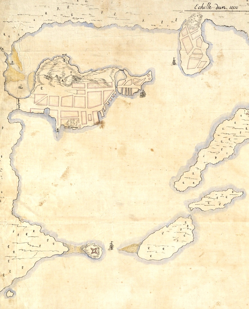
[编辑]| 描述 | Detail from a 1692 French map of Boston harbor. The Shawmut Peninsula, site of Boston is in the upper left, with Charlestown top center. Castle Island is visible to the lower left. |
| 日期 | |
| 来源 | Boston Public Library digital map collection: http://maps.bpl.org/details_10927/ |
| 作者 | Pierre d'Au de Jolliet |
| 其他版本 |
|
.jpg)
许可协议
[编辑]
|
这是一个平面公有领域艺术品的忠实摄影副本。原艺术品本身因为下列原因属于公有领域:
维基媒体基金会的官方立场认为:“对平面公有领域艺术品的忠实再制作品也属于公有领域。”
因此,可以认为此摄影副本在美国也属于公有领域。在其他司法管辖区,再利用此内容可能存在限制;参见再利用PD-Art照片了解详细信息。 | ||||
文件历史
点击某个日期/时间查看对应时刻的文件。
| 日期/时间 | 缩略图 | 大小 | 用户 | 备注 | |
|---|---|---|---|---|---|
| 当前 | 2011年4月14日 (四) 03:34 | | 1,024 × 1,271(487 KB) | Magicpiano(留言 | 贡献) | Contrast, brightness, level adjustments. |
| 2011年4月13日 (三) 21:00 |  | 1,024 × 1,271(422 KB) | Magicpiano(留言 | 贡献) | {{Information |Description=Detail from a 1692 French map of Boston harbor. The Shawmut Peninsula, site of Boston is in the upper left, with Charlestown top center. Castle Island is visible to the lower left. |Source=Boston Public Library digital map col |
您不可以覆盖此文件。
文件用途
以下2个页面使用本文件:
全域文件用途
以下其他wiki使用此文件:
- ar.wikipedia.org上的用途
- ca.wikipedia.org上的用途
- de.wikipedia.org上的用途
- en.wikipedia.org上的用途
- es.wikipedia.org上的用途
- fr.wikipedia.org上的用途
- it.wikipedia.org上的用途
- ja.wikipedia.org上的用途
- la.wikipedia.org上的用途
- pl.wikipedia.org上的用途
- pt.wikipedia.org上的用途
- sr.wikipedia.org上的用途
- zh.wikipedia.org上的用途