File:Burganlage-dieburg-schema.png
Jump to navigation
Jump to search

Size of this preview: 582 × 600 pixels. Other resolutions: 233 × 240 pixels | 466 × 480 pixels | 746 × 768 pixels | 994 × 1,024 pixels | 1,594 × 1,642 pixels.
Original file (1,594 × 1,642 pixels, file size: 830 KB, MIME type: image/png)
Captions
Captions
Add a one-line explanation of what this file represents
Summary[edit]
| Description |
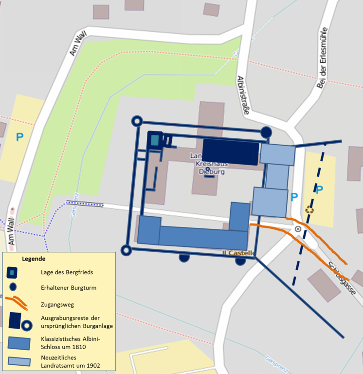
Deutsch: Lage und Größe der Burganlage Dieburg in Dieburg. Schematisiert sind die ehemaligen bekannten Burgteile vom Mittelalter bis in die Neuzeit eingetragen. Die Anbindung an die Stadtmauer der östlich gelegenen Altstadt und der ursprüngliche Zugangsweg zwischen Burg und Ort sind eingezeichnet. Die Kartenvorlage basiert auf OpenStreetMap.
|
| Date | |
| Source | Own work (Original text: own work) |
| Author | commander-pirx / Commander-pirx at German Wikipedia |
Licensing[edit]

|
Permission is granted to copy, distribute and/or modify this document under the terms of the GNU Free Documentation License, Version 1.2 or any later version published by the Free Software Foundation; with no Invariant Sections, no Front-Cover Texts, and no Back-Cover Texts. A copy of the license is included in the section entitled GNU Free Documentation License. |
This file is licensed under the Creative Commons Attribution-Share Alike 3.0 Unported license.
- You are free:
- to share – to copy, distribute and transmit the work
- to remix – to adapt the work
- Under the following conditions:
- attribution – You must give appropriate credit, provide a link to the license, and indicate if changes were made. You may do so in any reasonable manner, but not in any way that suggests the licensor endorses you or your use.
- share alike – If you remix, transform, or build upon the material, you must distribute your contributions under the same or compatible license as the original.
This file is licensed under the Creative Commons Attribution-Share Alike 3.0 Germany license.
- You are free:
- to share – to copy, distribute and transmit the work
- to remix – to adapt the work
- Under the following conditions:
- attribution – You must give appropriate credit, provide a link to the license, and indicate if changes were made. You may do so in any reasonable manner, but not in any way that suggests the licensor endorses you or your use.
- share alike – If you remix, transform, or build upon the material, you must distribute your contributions under the same or compatible license as the original.

| This work contains information from OpenStreetMap, which is made available under the Open Database License (ODbL).
The ODbL does not require any particular license for maps produced from ODbL data. Prior to 1 August 2020, map tiles produced by the OpenStreetMap Foundation were licensed under the CC-BY-SA-2.0 license. Maps produced by other people may be subject to other licences. |
Original upload log[edit]
The original description page was here. All following user names refer to de.wikipedia.
| Date/Time | Dimensions | User | Comment |
|---|---|---|---|
| 2013-10-21 21:29 | 1594×1642× (850225 bytes) | Commander-pirx | {{Information |Beschreibung = Lage und Größe der Burganlage Dieburg in [[Dieburg]]. Schematisiert sind die ehemaligen bekannten Burgteile vom Mittelalter bis in die Neuzeit eingetragen- Die Anbindung an die Stadtmauer der östlich gelegenen Altst… |
File history
Click on a date/time to view the file as it appeared at that time.
| Date/Time | Thumbnail | Dimensions | User | Comment | |
|---|---|---|---|---|---|
| current | 13:18, 27 August 2014 | | 1,594 × 1,642 (830 KB) | Nachcommonsverschieber (talk | contribs) | Transferred from de.wikipedia |
You cannot overwrite this file.
File usage on Commons
There are no pages that use this file.
File usage on other wikis
The following other wikis use this file:
- Usage on de.wikipedia.org