File:Carte de la Virginie, du Maryland et de l'etat de Delaware. NYPL433630.tiff
Jump to navigation
Jump to search

Size of this JPG preview of this TIF file: 800 × 491 pixels. Other resolutions: 320 × 197 pixels | 640 × 393 pixels | 1,024 × 629 pixels | 1,280 × 786 pixels | 2,560 × 1,572 pixels | 4,367 × 2,682 pixels.
Original file (4,367 × 2,682 pixels, file size: 33.51 MB, MIME type: image/tiff)
Captions
Captions
Add a one-line explanation of what this file represents
Summary[edit]
| Description | Carte de la Virginie, du Maryland et de l'etat de Delaware. | |||||||||||||||||||||||
| Notes | Lawrence H. Slaughter Collection. Note 2.) Prime meridians: Paris and Ferro. Note 3.) Relief shown pictorially. Note 4.) In upper right margin: Pl. 5. | |||||||||||||||||||||||
| Standard reference | Sabin 31899 Copy 1 | |||||||||||||||||||||||
| Physical description | 1 map ; 22 x 32 cm. folded to 18 x 11 cm. | |||||||||||||||||||||||
| Catalog Call Number | Map Div. 97-6458 (v.2, Pl. 5) [In LHS 3024] | |||||||||||||||||||||||
| Date | between 1781 and 1782 | |||||||||||||||||||||||
| Source |
http://digitalgallery.nypl.org/nypldigital/dgkeysearchdetail.cfm?imageID=433630
|
|||||||||||||||||||||||
| Author | Hilliard d'Auberteuil, Michel René, 1751-1789 -- Author | |||||||||||||||||||||||
| Permission (Reusing this file) |
From The Lionel Pincus & Princess Firyal Map Division. Released on a CC0 license.[1] | |||||||||||||||||||||||
| Source Description | 4 pt. in 2 v. front., plates, ports., fold. maps, fold. plan. 20.5 cm. | |||||||||||||||||||||||
| Digital ID | 433630 | |||||||||||||||||||||||
| Location | Stephen A. Schwarzman Building / The Lionel Pincus and Princess Firyal Map Division | |||||||||||||||||||||||
| NYPL digital item published | 2-28-2005; updated 1-9-2012 | |||||||||||||||||||||||

Licensing[edit]
| This file is made available under the Creative Commons CC0 1.0 Universal Public Domain Dedication. | |
| The person who associated a work with this deed has dedicated the work to the public domain by waiving all of their rights to the work worldwide under copyright law, including all related and neighboring rights, to the extent allowed by law. You can copy, modify, distribute and perform the work, even for commercial purposes, all without asking permission.
|
The making of this file was supported by Wikimedia UK.
To see other files made with the support of Wikimedia UK, please see the category Supported by Wikimedia UK.
|
File history
Click on a date/time to view the file as it appeared at that time.
| Date/Time | Thumbnail | Dimensions | User | Comment | |
|---|---|---|---|---|---|
| current | 20:51, 15 April 2014 | 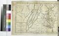 | 4,367 × 2,682 (33.51 MB) | Fæ (talk | contribs) | =={{int:filedesc}}== {{NYPL_map |source_description = 4 pt. in 2 v. front., plates, ports., fold. maps, fold. plan. 20.5 cm. |standard_reference = Sabin 31899 Copy 1 |record_id = 254121 |catalog_call_number = Map Div. 97-6458 (v.2, Pl. 5) [In LHS 3024]... |
You cannot overwrite this file.
File usage on Commons
There are no pages that use this file.