File:Carte des référendums d'origine populaire 2019.png
Jump to navigation
Jump to search
Size of this preview: 800 × 364 pixels. Other resolutions: 320 × 146 pixels | 640 × 291 pixels | 1,024 × 466 pixels | 1,280 × 582 pixels | 2,560 × 1,164 pixels | 5,841 × 2,656 pixels.
Original file (5,841 × 2,656 pixels, file size: 1.65 MB, MIME type: image/png)
Captions
Captions
Add a one-line explanation of what this file represents
Summary[edit]
| Description |
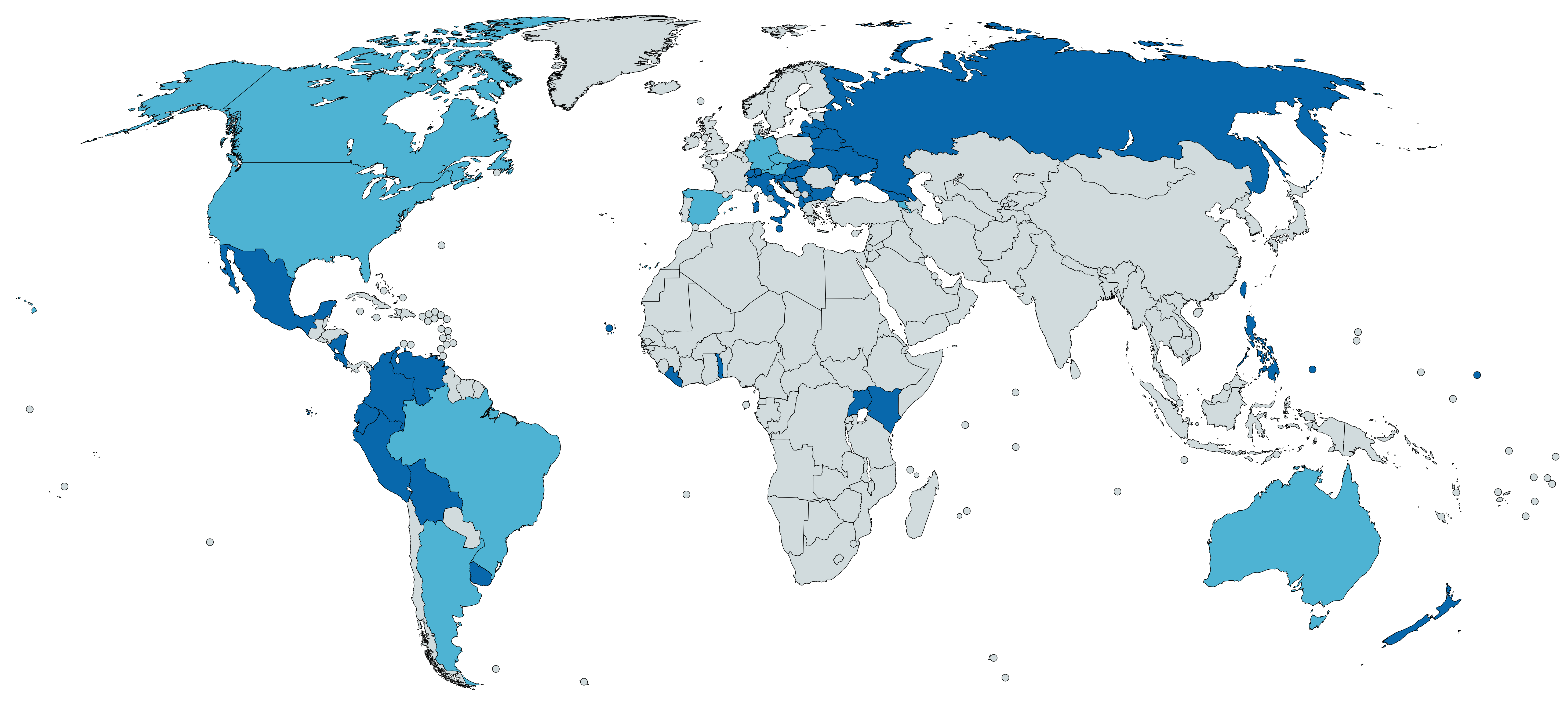
Français : Créé avec https://mapchart.net/ selon les informations de https://www.direct-democracy-navigator.org/ et des pages Wikipédia dédiées aux référendums dans les pays concernés
Possibles à l'échelon national
Possibles à l'échelon infranational uniquement |
| Date | |
| Source | Own work |
| Author | Aréat |

|
This map of the world image could be re-created using vector graphics as an SVG file. This has several advantages; see Commons:Media for cleanup for more information. If an SVG form of this image is available, please upload it and afterwards replace this template with
{{vector version available|new image name}}.
It is recommended to name the SVG file “Carte des référendums d'origine populaire 2019.svg”—then the template Vector version available (or Vva) does not need the new image name parameter. |
Licensing[edit]
| This map was created for free at MapChart.net. All maps created there are licensed under the Creative Commons Attribution-ShareAlike 4.0 International License. See the "Licensing" link on the home page, or the MapChart.net feedback page for the image license info, and this MapChart.net Commons discussion. Use {{Mapchart.net}} to provide attribution for maps created with that service.
See also: Other maps on Commons created with Mapchart.net: Category:Mapchart.net and this search query; other map and chart resources. |
I, the copyright holder of this work, hereby publish it under the following license:
This file is licensed under the Creative Commons Attribution-Share Alike 4.0 International license.
- You are free:
- to share – to copy, distribute and transmit the work
- to remix – to adapt the work
- Under the following conditions:
- attribution – You must give appropriate credit, provide a link to the license, and indicate if changes were made. You may do so in any reasonable manner, but not in any way that suggests the licensor endorses you or your use.
- share alike – If you remix, transform, or build upon the material, you must distribute your contributions under the same or compatible license as the original.
File history
Click on a date/time to view the file as it appeared at that time.
| Date/Time | Thumbnail | Dimensions | User | Comment | |
|---|---|---|---|---|---|
| current | 10:37, 15 January 2019 | | 5,841 × 2,656 (1.65 MB) | Aréat (talk | contribs) | Correction erreur de couleur pour Malte |
| 15:09, 13 January 2019 |  | 5,841 × 2,656 (1.65 MB) | Aréat (talk | contribs) | Mise à jour | |
| 22:34, 8 January 2019 |  | 5,924 × 2,639 (1.65 MB) | Aréat (talk | contribs) | Maj + format carte + légende à part | |
| 09:59, 6 January 2019 |  | 6,460 × 3,480 (1.97 MB) | Aréat (talk | contribs) | Oubli d'enlever la signature | |
| 21:52, 5 January 2019 |  | 6,460 × 3,480 (1.66 MB) | Aréat (talk | contribs) | +République Tchéque, Arménie et Russie au niveau local : https://brnodaily.cz/2017/09/29/breaking-news/local-referendums-often-held-in-czech-republic/ https://www.venice.coe.int/webforms/documents/default.aspx?pdffile=CDL-AD(2005)034-e page 31 | |
| 19:42, 4 January 2019 |  | 6,460 × 3,480 (1.97 MB) | Aréat (talk | contribs) | Moins la signature | |
| 19:37, 4 January 2019 |  | 6,460 × 3,480 (1.66 MB) | Aréat (talk | contribs) | User created page with UploadWizard |
You cannot overwrite this file.
File usage on Commons
The following page uses this file:
File usage on other wikis
The following other wikis use this file:
- Usage on en.wikipedia.org
- Usage on es.wikipedia.org
- Usage on fr.wikipedia.org
- Usage on hy.wikipedia.org