File:Carte du tendre 300dpi.jpg
Jump to navigation
Jump to search

Size of this preview: 800 × 574 pixels. Other resolutions: 320 × 229 pixels | 640 × 459 pixels | 1,024 × 734 pixels | 1,280 × 918 pixels | 2,560 × 1,836 pixels | 4,468 × 3,204 pixels.
Original file (4,468 × 3,204 pixels, file size: 22.11 MB, MIME type: image/jpeg)
Captions
Captions
Add a one-line explanation of what this file represents
Summary[edit]
| Description |
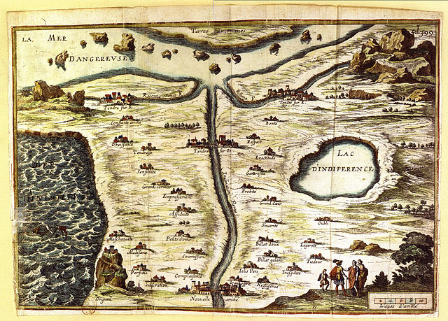
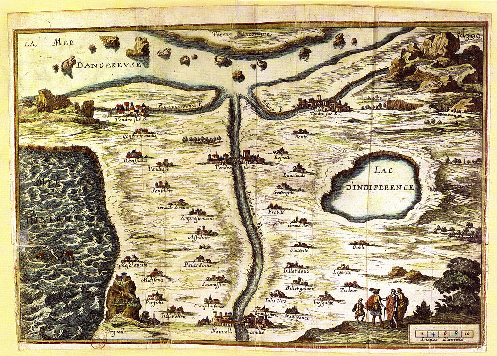
Français : Gravure: la Carte du Tendre, Paris, BNF.
La Carte de Tendre est la carte d’un pays imaginaire appelé « Tendre » imaginé au XVIIe siècle et inspiré par Clélie, Histoire romaine de Madeleine de Scudéry, par différentes personnalités dont Catherine de Rambouillet. On y retrouve tracées, sous forme de villages et de chemins, dans cette représentation topographique et allégorique, les différentes étapes de la vie amoureuse selon les Précieuses de l'époque. English: Allegorical map of the stages of love; starting near center top, one can go by way of the Reconaissance river (through the towns of Constante Amitié, Obeissance, Tendresse, Sensibilité, Grandes Services, Empressements, Assiduité, Petits Soins, Soumission, Complaisance) or by way of the Estime river (through the towns of Bonté, Respect, Exactitude, Generosité, Probité, Grand Coeur, Sincerité, Billet doux, Billet galant, Jolis Vers, and Grand esprit), or by way of the Inclination river (the most direct route) to arrive at the goal of Nouvelle Amitié. However, avoid Meschanceté, Médisance, Perfidie, Indiscretion, and Orgueil near the Mer d'Inimitié, as well as Oubli, Legereté, Tiedeur, Inegalité, and Negligence on the side of the Lac D'Indiference... |
|||||||||||||||||||||||
| Date | ||||||||||||||||||||||||
| Source | old engraving (see fr:Carte_de_Tendre) | |||||||||||||||||||||||
| Author |
|
|||||||||||||||||||||||
| Permission (Reusing this file) |
PD-old | |||||||||||||||||||||||
| Other versions | File:Pays de Tendre.jpg, File:Carte du tendre.jpg | |||||||||||||||||||||||

Licensing[edit]
|
This is a faithful photographic reproduction of a two-dimensional, public domain work of art. The work of art itself is in the public domain for the following reason:
The official position taken by the Wikimedia Foundation is that "faithful reproductions of two-dimensional public domain works of art are public domain".
This photographic reproduction is therefore also considered to be in the public domain in the United States. In other jurisdictions, re-use of this content may be restricted; see Reuse of PD-Art photographs for details. | ||||
File history
Click on a date/time to view the file as it appeared at that time.
| Date/Time | Thumbnail | Dimensions | User | Comment | |
|---|---|---|---|---|---|
| current | 20:42, 6 February 2015 | | 4,468 × 3,204 (22.11 MB) | M0tty (talk | contribs) | Remove regular noise using FFT |
| 01:00, 25 January 2013 |  | 4,468 × 3,204 (7.73 MB) | Slick-o-bot (talk | contribs) | Bot: convert to a non-interlaced jpeg (see bug #17645) | |
| 12:00, 24 August 2007 |  | 4,468 × 3,204 (6.97 MB) | Montex~commonswiki (talk | contribs) | {{Information |Description=Gravure: la Carte du Tendre Paris, BNF |Source= |Date= |Author= |Permission= |other_versions= }} |
You cannot overwrite this file.
File usage on Commons
There are no pages that use this file.
File usage on other wikis
The following other wikis use this file:
- Usage on en.wikipedia.org
- Usage on fr.wikipedia.org
- Usage on fr.wikisource.org
- Usage on nn.wikipedia.org
- Usage on no.wikipedia.org
- Usage on pl.wikipedia.org
- Usage on ru.wikipedia.org
- Usage on uk.wikipedia.org