File:Christopher Colombus third voyage 1498-1500 map-fr.svg
Jump to navigation
Jump to search

Size of this PNG preview of this SVG file: 800 × 523 pixels. Other resolutions: 320 × 209 pixels | 640 × 418 pixels | 1,024 × 669 pixels | 1,280 × 836 pixels | 2,560 × 1,673 pixels | 1,922 × 1,256 pixels.
Original file (SVG file, nominally 1,922 × 1,256 pixels, file size: 399 KB)
Captions
Captions
Add a one-line explanation of what this file represents
Summary[edit]
| Description |
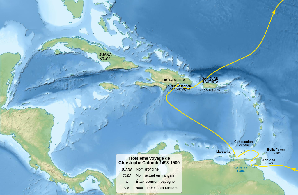
English: Map of Christopher Columbus third voyage, between 1498 and 1500. Français : Carte du troisième voyage de Christophe Colomb, de 1498 à 1500. Equirectangular projection, WGS84 datum
Geographic limits of the map:
|
||
| Date | (UTC) | ||
| Source | |||
| Author |
|
||
| Other versions | |||
| Attribution (required by the license) | © Sémhur / Wikimedia Commons / | ||
| SVG | W3C-validity not checked.
|
||
| Graphic Lab |

| Camera location | | View this and other nearby images on: OpenStreetMap |
|---|
Licensing[edit]
I, the copyright holder of this work, hereby publish it under the following licenses:
| Copyleft: This work of art is free; you can redistribute it and/or modify it according to terms of the Free Art License. You will find a specimen of this license on the Copyleft Attitude site as well as on other sites. |
This file is licensed under the Creative Commons Attribution-Share Alike 4.0 International, 3.0 Unported, 2.5 Generic, 2.0 Generic and 1.0 Generic license.
- You are free:
- to share – to copy, distribute and transmit the work
- to remix – to adapt the work
- Under the following conditions:
- attribution – You must give appropriate credit, provide a link to the license, and indicate if changes were made. You may do so in any reasonable manner, but not in any way that suggests the licensor endorses you or your use.
- share alike – If you remix, transform, or build upon the material, you must distribute your contributions under the same or compatible license as the original.
You may select the license of your choice.
Original upload log[edit]
This image is a derivative work of the following images:
- File:Christopher_Columbus_voyages_map-fr.svg licensed with Cc-by-sa-3.0,2.5,2.0,1.0, GFDL
- 2011-02-18T10:56:07Z Sémhur 1922x1256 (408928 Bytes) Increase text size
- 2011-02-13T21:28:18Z Sémhur 1922x1256 (364137 Bytes) == {{int:filedesc}} == {{Information |Description={{Multilingual description |en=Map of [[:en:Christopher Columbus|Christopher Columbus]] voyages, between 1492 and 1504. |fr=Carte des voyages de [[:fr:Christophe Colomb|Christ
Uploaded with derivativeFX
File history
Click on a date/time to view the file as it appeared at that time.
| Date/Time | Thumbnail | Dimensions | User | Comment | |
|---|---|---|---|---|---|
| current | 15:26, 18 February 2011 | | 1,922 × 1,256 (399 KB) | Sémhur (talk | contribs) | == {{int:filedesc}} == {{Information |Description={{Multilingual description |en=Map of Christopher Columbus third voyage, between 1498 and 1500. |fr=Carte du deuxième voyage de Christophe Colomb, |
You cannot overwrite this file.
File usage on Commons
The following page uses this file:
- File:Christopher Colombus first voyage 1498-1500 map-fr.svg (file redirect)
File usage on other wikis
The following other wikis use this file: