File:Church by Casselmans Bridge.jpg
Jump to navigation
Jump to search

Size of this preview: 800 × 600 pixels. Other resolutions: 320 × 240 pixels | 640 × 480 pixels | 1,024 × 768 pixels | 1,280 × 960 pixels | 2,560 × 1,920 pixels | 2,816 × 2,112 pixels.
Original file (2,816 × 2,112 pixels, file size: 1.51 MB, MIME type: image/jpeg)
Captions
Captions
Add a one-line explanation of what this file represents
| Camera location | | View this and other nearby images on: OpenStreetMap |
|---|
| Description |
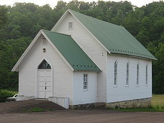
English: Front and eastern side of a church located on the northern side of the original route of the National Road near Casselmans Bridge, just east of Grantsville in Garrett County, Maryland, United States. |
||
| Date | Taken on 20 June 2013 | ||
| Source | Own work | ||
| Author | Nyttend | ||
| Permission (Reusing this file) |
|
File history
Click on a date/time to view the file as it appeared at that time.
| Date/Time | Thumbnail | Dimensions | User | Comment | |
|---|---|---|---|---|---|
| current | 21:15, 30 June 2013 | | 2,816 × 2,112 (1.51 MB) | Nyttend (talk | contribs) | {{Location|39|41|49.5|N|79|8|30.5|W}} {{Information |Description={{en|Front and eastern side of a church located on the northern side of the original route of the {{w|National Road}} near {{w|Casselmans Bridge}}, just east of {{w|Grantsville, Maryland|... |
You cannot overwrite this file.
File usage on Commons
There are no pages that use this file.