File:Chuvas Espírito Santo 2020.svg
Jump to navigation
Jump to search

Size of this PNG preview of this SVG file: 411 × 599 pixels. Other resolutions: 165 × 240 pixels | 329 × 480 pixels | 527 × 768 pixels | 703 × 1,024 pixels | 1,405 × 2,048 pixels | 512 × 746 pixels.
Original file (SVG file, nominally 512 × 746 pixels, file size: 90 KB)
Captions
Captions
Add a one-line explanation of what this file represents
Summary[edit]
| Description |
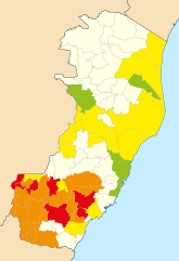
Português: Mapa das ocorrências das chuvas no Espírito Santo em 2020, baseado em dados da Defesa Civil Estadual do Espírito Santo.
|
|
| Date | ||
| Source | Own work | |
| Author | MayTheForce, based on File:Brazil Espirito Santo location map.svg |
Licensing[edit]
I, the copyright holder of this work, hereby publish it under the following license:
This file is licensed under the Creative Commons Attribution-Share Alike 4.0 International license.
- You are free:
- to share – to copy, distribute and transmit the work
- to remix – to adapt the work
- Under the following conditions:
- attribution – You must give appropriate credit, provide a link to the license, and indicate if changes were made. You may do so in any reasonable manner, but not in any way that suggests the licensor endorses you or your use.
- share alike – If you remix, transform, or build upon the material, you must distribute your contributions under the same or compatible license as the original.
File history
Click on a date/time to view the file as it appeared at that time.
| Date/Time | Thumbnail | Dimensions | User | Comment | |
|---|---|---|---|---|---|
| current | 02:00, 1 February 2020 | | 512 × 746 (90 KB) | MayTheForce (talk | contribs) | Última atualização: http://eshoje.com.br/wp-content/uploads/2020/01/Release-30-01-2020-06h-1.pdf |
| 20:30, 28 January 2020 |  | 512 × 746 (90 KB) | MayTheForce (talk | contribs) | [http://eshoje.com.br/wp-content/uploads/2020/01/Release-28-01-2020-06h.pdf Atualização] | |
| 02:08, 27 January 2020 |  | 512 × 746 (90 KB) | MayTheForce (talk | contribs) | Morte em Cachoeiro | |
| 00:03, 27 January 2020 |  | 512 × 746 (90 KB) | MayTheForce (talk | contribs) | Atualização | |
| 21:22, 26 January 2020 |  | 512 × 746 (90 KB) | MayTheForce (talk | contribs) | Correção (faltava Alto Rio Novo) | |
| 17:26, 26 January 2020 |  | 512 × 746 (90 KB) | MayTheForce (talk | contribs) | Atualização | |
| 23:07, 25 January 2020 |  | 512 × 746 (90 KB) | MayTheForce (talk | contribs) | Atualização | |
| 18:40, 25 January 2020 |  | 512 × 746 (90 KB) | MayTheForce (talk | contribs) | Atualização | |
| 02:16, 24 January 2020 |  | 512 × 746 (90 KB) | MayTheForce (talk | contribs) | De acordo com https://www.agazeta.com.br/es/norte/chuva-alaga-casas-e-interdita-rodovia-em-sao-roque-do-canaa-0120 | |
| 20:49, 23 January 2020 |  | 512 × 746 (90 KB) | MayTheForce (talk | contribs) | Novos municípios afetados |
You cannot overwrite this file.
File usage on Commons
There are no pages that use this file.
File usage on other wikis
The following other wikis use this file:
- Usage on en.wikipedia.org
- Usage on es.wikipedia.org
- Usage on pt.wikipedia.org