File:Cincinnati Frequent Transit Map.png
Jump to navigation
Jump to search

Size of this preview: 800 × 556 pixels. Other resolutions: 320 × 222 pixels | 640 × 445 pixels | 1,024 × 712 pixels | 1,280 × 890 pixels | 2,560 × 1,780 pixels | 3,294 × 2,290 pixels.
Original file (3,294 × 2,290 pixels, file size: 1.78 MB, MIME type: image/png)
Captions
Captions
Add a one-line explanation of what this file represents
Summary[edit]
| Description |
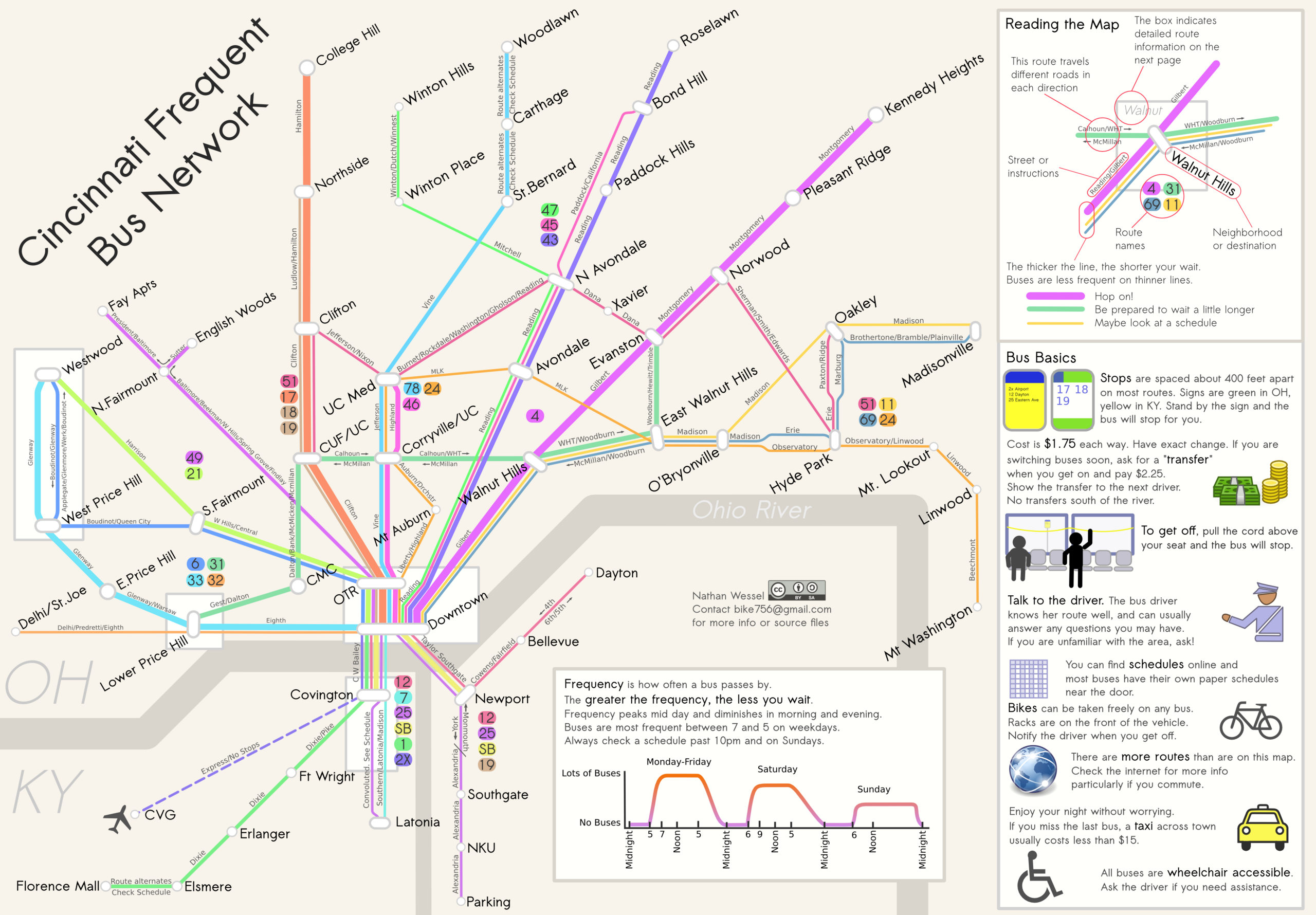
English: Frequency map for Cincinnati's transit system as it exists in early 2011. |
| Date | |
| Source | Own work |
| Author | Bike756 |
| Other versions | http://www.cincymap.org |
Licensing[edit]
I, the copyright holder of this work, hereby publish it under the following license:
This file is licensed under the Creative Commons Attribution 3.0 Unported license.
- You are free:
- to share – to copy, distribute and transmit the work
- to remix – to adapt the work
- Under the following conditions:
- attribution – You must give appropriate credit, provide a link to the license, and indicate if changes were made. You may do so in any reasonable manner, but not in any way that suggests the licensor endorses you or your use.
File history
Click on a date/time to view the file as it appeared at that time.
| Date/Time | Thumbnail | Dimensions | User | Comment | |
|---|---|---|---|---|---|
| current | 05:09, 30 January 2011 | | 3,294 × 2,290 (1.78 MB) | Nate Wessel (talk | contribs) | {{Information |Description ={{en|1=Frequency map for Cincinnati's transit system as it exists in early 2011.}} |Source ={{own}} |Author =Bike756 |Date =2011-01-30 |Permission = |other_versions = }} [[Cate |
You cannot overwrite this file.
File usage on Commons
There are no pages that use this file.