File:Claims of democracy.png
Jump to navigation
Jump to search
Size of this preview: 800 × 370 pixels. Other resolutions: 320 × 148 pixels | 640 × 296 pixels | 1,357 × 628 pixels.
Original file (1,357 × 628 pixels, file size: 108 KB, MIME type: image/png)
Captions
Captions
Add a one-line explanation of what this file represents
Summary[edit]
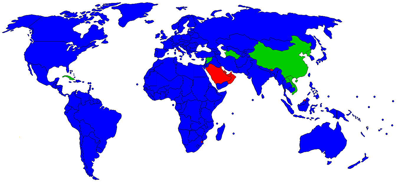
| Description | Colour-coded map of the world showing which governments claim to be democratic. It is meant to express the de jure situation. |
| Date | |
| Source | I made it myself using the map of forms of government made by The Tom, together with information from the CIA World Factbook. |
| Author | Nikodemos |
| Permission (Reusing this file) |
GFDL |
Countries are colour-coded based on their respective governments' claims with regard to democracy.
- Blue - Governments that claim to be democratic and allow opposition parties to exist (though in some cases those opposition parties may be persecuted).
- Green - Governments that claim to be democratic but do not allow opposition parties to exist.
- Red - Governments that do not claim to be democratic.
Licensing[edit]

|
Permission is granted to copy, distribute and/or modify this document under the terms of the GNU Free Documentation License, Version 1.2 or any later version published by the Free Software Foundation; with no Invariant Sections, no Front-Cover Texts, and no Back-Cover Texts. A copy of the license is included in the section entitled GNU Free Documentation License. |
| This file is licensed under the Creative Commons Attribution-Share Alike 3.0 Unported license. | ||
| ||
| This licensing tag was added to this file as part of the GFDL licensing update. |
File history
Click on a date/time to view the file as it appeared at that time.
| Date/Time | Thumbnail | Dimensions | User | Comment | |
|---|---|---|---|---|---|
| current | 18:57, 25 August 2012 | | 1,357 × 628 (108 KB) | Hamodi1234 (talk | contribs) | Fixed Burma |
| 18:49, 25 August 2012 |  | 1,357 × 628 (108 KB) | Hamodi1234 (talk | contribs) | Fixed Libya | |
| 08:11, 1 February 2008 |  | 1,357 × 628 (85 KB) | Xiong Chiamiov (talk | contribs) | optimized using optipng | |
| 20:07, 27 June 2006 |  | 1,357 × 628 (101 KB) | Nikodemos (talk | contribs) | {{Information |Description=Colour-coded map of the world showing which governments claim to be democratic. It is meant to express the ''de jure'' situation. |Source=I made it myself using the [http://commons.wikimedia.org/wiki/Image:Form_of_government.png |
You cannot overwrite this file.
File usage on Commons
There are no pages that use this file.
File usage on other wikis
The following other wikis use this file:
- Usage on ar.wikipedia.org
- Usage on cs.wikipedia.org
- Usage on en.wikipedia.org
- Usage on es.wikipedia.org
- Usage on fr.wikipedia.org
- Usage on mk.wikipedia.org
- Usage on ta.wikipedia.org
- Usage on zh-yue.wikipedia.org