File:Claw-shaped clast in basaltic lapillistone (Middle Tholeiitic Unit, Kidd-Munro Assemblage, Neoarchean, 2.711-2.719 Ga; just east of the Potter Mine, east of Timmins, Ontario, Canada) 1 (47076494094).jpg

Original file (4,000 × 3,000 pixels, file size: 12.71 MB, MIME type: image/jpeg)
Captions
Captions
Summary[edit]
_1_(47076494094).jpg&action=edit§ion=1)
| Description |
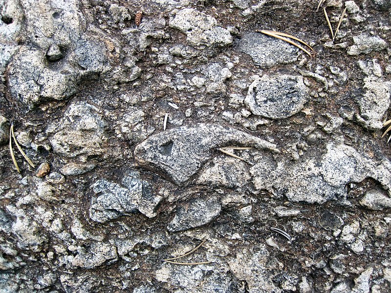
Basaltic lapillistone in the Precambrian of Ontario, Canada. These unusual-looking rocks are part of the Late Archean-aged Kidd-Munro Assemblage, which consists of ultramafic and mafic volcanic rocks intruded by mafic to ultramafic dikes and sill-like bodies. Minor felsic volcanic rocks are also present. Volcanogenic massive sulfide deposits occur in the Kidd-Munro Assemblage - they have been mined at the Texas Gulf Mine and the Potter Mine. This outcrop consists of clast-supported, coarse-grained, fragmental tholeiitic basalt - it's a tholeiitic basalt breccia (it's also been characterized as a hyaloclastite). The fragments vary in shape from angular to agglutinated to convoluted, including delicate shapes. This indicates no fragment transport. If transport had occurred, the tip of this claw-shaped clast would have been abraded or broken away. Fragments vary significantly in size, but most are lapilli-sized (= volcanic fragments between 2 and 64 millimeters). This rock has been interpreted as a proximal vent facies/spatter rampart deposit. An underwater, volcanic fissure eruption occurred here 2.7 billion years ago, resulting in subaqueous fire fountaining. This was the site of an ancient volcanic edifice. Description of site from Houlé et al. (2010) [sans parenthetical citations]: Approximately 500 meters east of the Potter Mine area, the basaltic volcaniclastic rocks are massive to poorly bedded, unsorted, and consist of globular, irregular "moulded" lapilli that resemble agglutinate, fluidal bombs, cored bombs, blocks, and armoured lapilli, with less than 10% matrix containing fine, plate-like hyaloclastite shards and lapilli. Accessory fragments of chert, carbonaceous mudstone, argillaceous mudstone, and massive sulfide account for less than 1% of the breccia. The basaltic volcaniclastic rocks were previously interpreted to have been derived through quench fragmentation and autobrecciation of basaltic flows. However, the lack of basalt flows and in situ hyaloclastite, the abundance of fluidal and cored bombs, armoured lapilli, globular lapilli, and the shear volume of breccia led Gibson and Gamble (2000) to propose an origin through "explosive fragmentation" rather than autobrecciation. The production of large volumes of lapilli-size granules is interpreted to be a product of the rapid eruption of low-viscosity mafic magma into a water column, where the magma was jetted into the water column, torn apart, and quench fragmented. In this model, massive, poorly sorted tuff breccia containing globular, lapilli-size agglutinate and fluidal bombs are interpreted to represent vent-proximal deposits, similar to subaerial fire fountain and spatter rampart deposits. Stratigraphy: Middle Tholeiitic Unit, Kidd-Munro Assemblage, Abitibi Greenstone Belt, lower Neoarchean, 2.711-2.719 Ga Locality: outcrop along ridge just south of little dirt road that is due-east of the Potter Mine & due-west of Pyke Hill, north of Route 101, east-northeast of Matheson & south of the western end of Lake Abitibi & ~83 kilometers east of the city of Timmins, Munro Township, southern Cochrane District, eastern Ontario, southeastern Canada (vicinity of 48° 35' 55.07" North latitude, 80° 12' 24.20" West longitude) (= locality 2c east of the Potter Mine in Fyon & Green, 1991 - Geology and ore deposits of the Timmins District, Ontario (field trip 6), Geological Survey of Canada Open File 2161, p. 27 (fig. N12).) (= stop 2.2C of Houlé et al., 2010 - Stratigraphy and physical volcanology of komatiites and associated Ni-Cu-(PGE) mineralization in the western Abitibi Greenstone Belt, Timmins area, Ontario: a field trip for the 11th International Platinum Symposium. Ontario Geological Survey Open File Report 6255, p. 34 (figure 16) & p. 39.) |
| Date | |
| Source | Claw-shaped clast in basaltic lapillistone (Middle Tholeiitic Unit, Kidd-Munro Assemblage, Neoarchean, 2.711-2.719 Ga; just east of the Potter Mine, east of Timmins, Ontario, Canada) 1 |
| Author | James St. John |
Licensing[edit]
_1_(47076494094).jpg&action=edit§ion=2)
- You are free:
- to share – to copy, distribute and transmit the work
- to remix – to adapt the work
- Under the following conditions:
- attribution – You must give appropriate credit, provide a link to the license, and indicate if changes were made. You may do so in any reasonable manner, but not in any way that suggests the licensor endorses you or your use.
| This image was originally posted to Flickr by James St. John at https://flickr.com/photos/47445767@N05/47076494094 (archive). It was reviewed on 5 December 2019 by FlickreviewR 2 and was confirmed to be licensed under the terms of the cc-by-2.0. |
File history
Click on a date/time to view the file as it appeared at that time.
| Date/Time | Thumbnail | Dimensions | User | Comment | |
|---|---|---|---|---|---|
| current | 06:05, 5 December 2019 | | 4,000 × 3,000 (12.71 MB) | Ser Amantio di Nicolao (talk | contribs) | Transferred from Flickr via #flickr2commons |
You cannot overwrite this file.
File usage on Commons
There are no pages that use this file.
_1_(47076494094).jpg&oldid=861871698)