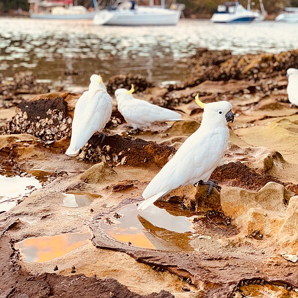
File:Cockatoos at Folly Point, Cammeray captured by Kate Branch.jpg

Original file (1,024 × 1,024 pixels, file size: 1.14 MB, MIME type: image/jpeg)
Captions
Captions
Summary[edit]
| DescriptionCockatoos at Folly Point, Cammeray captured by Kate Branch.jpg |
English: Cammeray takes its name from the Cammeraygal people, an Aboriginal clan who once occupied the lower North Shore. Radiometric dating (carbon dating) indicates that indigenous peoples lived in the Cammeray area at least 5,800 years ago and Aboriginal shell middens have been discovered at Folly Point and cave paintings in Primrose Park. Prior to the 1920s, the suburb was known as Suspension Bridge reflecting the now Long Gully Bridge that joined Northbridge to Cammeray. Cammeray was slow to develop mainly due to its steep topography and remoteness from transport.
Despite the land boom of the 1880s and plans for a suspension bridge across Flat Rock Creek, development in the Cammeray area was mostly confined to the south of the suburb with some boatmen‟s houses on Folly Point.- From Wikipedia |
| Date | |
| Source | Own work |
| Author | Kate Branch |
| Camera location | 33° 49′ 22.8″ S, 151° 12′ 36.72″ E | View this and other nearby images on: OpenStreetMap |
|---|
Cammeray takes its name from the Cammeraygal people, an Aboriginal clan who once occupied the lower North Shore. Radiometric dating (carbon dating) indicates that indigenous peoples lived in the Cammeray area at least 5,800 years ago and Aboriginal shell middens have been discovered at Folly Point and cave paintings in Primrose Park. Prior to the 1920s, the suburb was known as Suspension Bridge reflecting the now Long Gully Bridge that joined Northbridge to Cammeray. Cammeray was slow to develop mainly due to its steep topography and remoteness from transport.
Despite the land boom of the 1880s and plans for a suspension bridge across Flat Rock Creek, development in the Cammeray area was mostly confined to the south of the suburb with some boatmen‟s houses on Folly Point. From Wikipedia
Licensing[edit]
- You are free:
- to share – to copy, distribute and transmit the work
- to remix – to adapt the work
- Under the following conditions:
- attribution – You must give appropriate credit, provide a link to the license, and indicate if changes were made. You may do so in any reasonable manner, but not in any way that suggests the licensor endorses you or your use.
- share alike – If you remix, transform, or build upon the material, you must distribute your contributions under the same or compatible license as the original.
File history
Click on a date/time to view the file as it appeared at that time.
| Date/Time | Thumbnail | Dimensions | User | Comment | |
|---|---|---|---|---|---|
| current | 01:01, 24 February 2020 |  | 1,024 × 1,024 (1.14 MB) | Kate Branch Photography (talk | contribs) | User created page with UploadWizard |
You cannot overwrite this file.
File usage on Commons
There are no pages that use this file.
Metadata
This file contains additional information such as Exif metadata which may have been added by the digital camera, scanner, or software program used to create or digitize it. If the file has been modified from its original state, some details such as the timestamp may not fully reflect those of the original file. The timestamp is only as accurate as the clock in the camera, and it may be completely wrong.
| Image title |
|
|---|---|
| Camera manufacturer | Apple |
| Camera model | iPhone XS Max |
| Exposure time | 1/75 sec (0.013333333333333) |
| F-number | f/2.4 |
| ISO speed rating | 125 |
| Date and time of data generation | 05:43, 24 November 2018 |
| Lens focal length | 6 mm |
| Orientation | Normal |
| Horizontal resolution | 72 dpi |
| Vertical resolution | 72 dpi |
| Software used | Photos 4.0 |
| File change date and time | 05:43, 24 November 2018 |
| Exposure Program | Normal program |
| Exif version | 2.21 |
| Date and time of digitizing | 05:43, 24 November 2018 |
| Meaning of each component |
|
| APEX shutter speed | 6.2277731209835 |
| APEX aperture | 2.5260688112782 |
| APEX brightness | 4.0288545810018 |
| APEX exposure bias | 0 |
| Metering mode | Spot |
| Flash | Flash did not fire, compulsory flash suppression |
| DateTimeOriginal subseconds | 005 |
| DateTimeDigitized subseconds | 005 |
| Supported Flashpix version | 1 |
| Color space | sRGB |
| Sensing method | One-chip color area sensor |
| Scene type | A directly photographed image |
| Custom image processing | Normal process |
| Exposure mode | Auto exposure |
| White balance | Auto white balance |
| Focal length in 35 mm film | 52 mm |
| Scene capture type | Standard |
| Keywords | kate branch |
| IIM version | 2 |