File:Code of Hammurabi, 16 July 2010.jpg
Jump to navigation
Jump to search

Size of this preview: 220 × 600 pixels. Other resolutions: 88 × 240 pixels | 176 × 480 pixels | 281 × 768 pixels | 1,025 × 2,794 pixels.
Original file (1,025 × 2,794 pixels, file size: 1.2 MB, MIME type: image/jpeg)
Captions
Captions
Add a one-line explanation of what this file represents
Summary
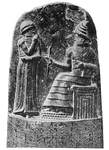
Object
| stele with the code of Hammurabi
|
||||||||||||||||||||||||
|---|---|---|---|---|---|---|---|---|---|---|---|---|---|---|---|---|---|---|---|---|---|---|---|---|
| Artist |  | |||||||||||||||||||||||
| Title |
Stele of Hammurabi |
|||||||||||||||||||||||
| Object type |
stele / sculpture / archaeological artifact |
|||||||||||||||||||||||
| Genre |
Babylonia |
|||||||||||||||||||||||
| Depicted people |
Hammurabi |
|||||||||||||||||||||||
| Date |
between circa 1793 and circa 1751 BC |
|||||||||||||||||||||||
| Medium |
black basalt and engraving |
|||||||||||||||||||||||
| Dimensions |
height: 225 cm (88.5 in) |
|||||||||||||||||||||||
| Collection |
|
|||||||||||||||||||||||
| Current location | ||||||||||||||||||||||||
| Accession number | ||||||||||||||||||||||||
| Object location |
|
|||||||||||||||||||||||
| Place of creation |
Mesopotamia |
|||||||||||||||||||||||
| Place of discovery |
Susa |
|||||||||||||||||||||||
| Object history |
|
|||||||||||||||||||||||
| References | ||||||||||||||||||||||||
| Authority file | ||||||||||||||||||||||||
| Other versions |
|
|||||||||||||||||||||||


Photograph
| Date | |||
| Source | Own work | ||
| Author | Rmashhadi | ||
| Permission (Reusing this file) |
|
File history
Click on a date/time to view the file as it appeared at that time.
| Date/Time | Thumbnail | Dimensions | User | Comment | |
|---|---|---|---|---|---|
| current | 01:35, 22 April 2011 | 1,025 × 2,794 (1.2 MB) | Reza1615 (talk | contribs) |
You cannot overwrite this file.
File usage on Commons
The following 3 pages use this file:
.JPG&redirect=no)