File:Constantim e Vale de Nogueiras (Vila Real) localização.svg
Jump to navigation
Jump to search

Size of this PNG preview of this SVG file: 532 × 599 pixels. Other resolutions: 213 × 240 pixels | 426 × 480 pixels | 682 × 768 pixels | 909 × 1,024 pixels | 1,819 × 2,048 pixels | 2,442 × 2,750 pixels.
Original file (SVG file, nominally 2,442 × 2,750 pixels, file size: 567 KB)
Captions
Captions
Add a one-line explanation of what this file represents
Summary[edit]
_localiza%C3%A7%C3%A3o.svg&action=edit§ion=1)
| Description |
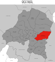
English: Location of the Union of Civil Parishes of Constantim and Vale de Nogueiras within the municipality of Vila Real (Portugal) Português: Localização da União das Freguesias de Constantim e Vale de Nogueiras no concelho de Vila Real |
| Date | |
| Source | File:Vila_Real_freguesias_2013.svg |
| Author | Gazilion |
Licensing[edit]
_localiza%C3%A7%C3%A3o.svg&action=edit§ion=2)
I, the copyright holder of this work, hereby publish it under the following license:
| This file is made available under the Creative Commons CC0 1.0 Universal Public Domain Dedication. | |
| The person who associated a work with this deed has dedicated the work to the public domain by waiving all of their rights to the work worldwide under copyright law, including all related and neighboring rights, to the extent allowed by law. You can copy, modify, distribute and perform the work, even for commercial purposes, all without asking permission.
|
File history
Click on a date/time to view the file as it appeared at that time.
| Date/Time | Thumbnail | Dimensions | User | Comment | |
|---|---|---|---|---|---|
| current | 15:22, 14 April 2015 | | 2,442 × 2,750 (567 KB) | Gazilion (talk | contribs) | Scale added; other minor adjustments |
| 10:10, 14 March 2014 |  | 1,750 × 1,741 (650 KB) | Gazilion (talk | contribs) | More accurate boundaries (official GIS data, see source for link). Neighbouring municipalities included. | |
| 19:41, 6 February 2014 |  | 3,762 × 3,772 (331 KB) | Gazilion (talk | contribs) | User created page with UploadWizard |
You cannot overwrite this file.
File usage on Commons
The following 2 pages use this file:
File usage on other wikis
The following other wikis use this file:
- Usage on es.wikipedia.org
- Usage on pt.wikipedia.org
- Usage on www.wikidata.org
_localização.svg&oldid=867629663)