File:DAM CATWALK FACING SOUTHEAST TO SCREENHOUSE, GATE, AND GARAGE - Cove Hydroelectric Development, Forebay and Diversion Dam, Cove Power Plant Road, Grace, Caribou County, ID HAER ID-43-A-1.tif
Jump to navigation
Jump to search

Size of this JPG preview of this TIF file: 742 × 599 pixels. Other resolutions: 297 × 240 pixels | 594 × 480 pixels | 951 × 768 pixels | 1,268 × 1,024 pixels | 2,536 × 2,048 pixels | 5,528 × 4,465 pixels.
Original file (5,528 × 4,465 pixels, file size: 23.54 MB, MIME type: image/tiff)
Captions
Captions
Add a one-line explanation of what this file represents
Summary[edit]
| DAM CATWALK FACING SOUTHEAST TO SCREENHOUSE, GATE, AND GARAGE - Cove Hydroelectric Development, Forebay and Diversion Dam, Cove Power Plant Road, Grace, Caribou County, ID | ||||
|---|---|---|---|---|
| Photographer |
Steely, James Related names:
|
|||
| Title |
DAM CATWALK FACING SOUTHEAST TO SCREENHOUSE, GATE, AND GARAGE - Cove Hydroelectric Development, Forebay and Diversion Dam, Cove Power Plant Road, Grace, Caribou County, ID |
|||
| Depicted place | Idaho; Caribou County; Grace | |||
| Date | 2006 | |||
| Dimensions | 4 x 5 in. | |||
| Current location |
Library of Congress Prints and Photographs Division Washington, D.C. 20540 USA http://hdl.loc.gov/loc.pnp/pp.print |
|||
| Accession number |
HAER ID-43-A-1 |
|||
| Credit line |
|
|||
| Notes |
|
|||
| Source | https://www.loc.gov/pictures/item/id0448.photos.220154p | |||
| Permission (Reusing this file) |
|
|||

| Object location | | View this and other nearby images on: OpenStreetMap |
|---|
File history
Click on a date/time to view the file as it appeared at that time.
| Date/Time | Thumbnail | Dimensions | User | Comment | |
|---|---|---|---|---|---|
| current | 23:06, 15 July 2014 | 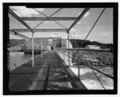 | 5,528 × 4,465 (23.54 MB) | Fæ (talk | contribs) | GWToolset: Creating mediafile for Fæ. HABS 11 July 2014 (1001:1200) |
You cannot overwrite this file.
File usage on Commons
The following page uses this file: