File:DETAIL OF ROOF TRUSS - U.S. Naval Base, Pearl Harbor, Hangar 6, South End of Ford Island, Pearl City, Honolulu County, HI HAER HI,2-HONLU,1-21.tif
Jump to navigation
Jump to search

Size of this JPG preview of this TIF file: 791 × 600 pixels. Other resolutions: 317 × 240 pixels | 633 × 480 pixels | 1,013 × 768 pixels | 1,280 × 971 pixels | 2,560 × 1,942 pixels | 5,000 × 3,792 pixels.
Original file (5,000 × 3,792 pixels, file size: 18.08 MB, MIME type: image/tiff)
Captions
Captions
Add a one-line explanation of what this file represents
Summary[edit]
| DETAIL OF ROOF TRUSS - U.S. Naval Base, Pearl Harbor, Hangar 6, South End of Ford Island, Pearl City, Honolulu County, HI | ||||
|---|---|---|---|---|
| Photographer |
Related names:
|
|||
| Title |
DETAIL OF ROOF TRUSS - U.S. Naval Base, Pearl Harbor, Hangar 6, South End of Ford Island, Pearl City, Honolulu County, HI |
|||
| Depicted place | Hawaii; Honolulu County; Pearl City | |||
| Date | Documentation compiled after 1968 | |||
| Dimensions | 4 x 5 in. | |||
| Current location |
Library of Congress Prints and Photographs Division Washington, D.C. 20540 USA http://hdl.loc.gov/loc.pnp/pp.print |
|||
| Accession number |
HAER HI,2-HONLU,1-21 |
|||
| Credit line |
|
|||
| Notes |
|
|||
| References |
|
|||
| Source | https://www.loc.gov/pictures/item/hi0060.photos.057821p | |||
| Permission (Reusing this file) |
|
|||

| Object location | | View this and other nearby images on: OpenStreetMap |
|---|
File history
Click on a date/time to view the file as it appeared at that time.
| Date/Time | Thumbnail | Dimensions | User | Comment | |
|---|---|---|---|---|---|
| current | 12:11, 11 July 2014 | 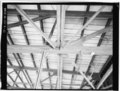 | 5,000 × 3,792 (18.08 MB) | Fæ (talk | contribs) | GWToolset: Creating mediafile for Fæ. HABS 11 July 2014 (1001:1200) |
You cannot overwrite this file.
File usage on Commons
The following page uses this file: