File:Dresden Bürgerwiese Mozartdenkmal 06.JPG

Original file (2,112 × 2,816 pixels, file size: 3.44 MB, MIME type: image/jpeg)
Captions
Captions
Summary[edit]
| Description |
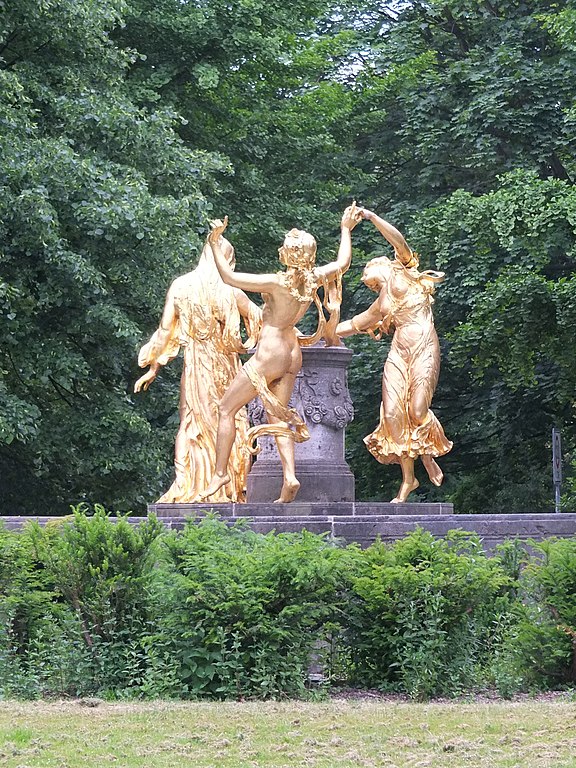
Nederlands: Het Mozartmonument (1907) van de hand van Hermann Hosaeus in het park Bürgerwiese te Dresden.
Rondom een zuil waarop de naam Mozart staat dansen de drie vrouwelijke figuren Gratie, Vreugde en Ernst (Anmut, Heitigkeit, Ernst) een reidans. Het beeld werd tijdens het bombardement van Dresden in februari 1945 vernietigd. In 1991 werd, naar aanleiding van de tweehonderdste verjaardag van de dood van Mozart, een replica van de hand van Eberhard Wolf onthuld.English: The Mozart monument (1907) by Hermann Hosaeus in the Bürgerwiese park in Dresden.
Three females, Grace, Joy and Seriousness dance around a small pillar which is inscribed with the word Mozart. The statue was destroyed during the bombing of Dresden in February 1945. A copy by Eberhard Wolf was unveiled in 1991, at the 200th anniversary of Mozart's death. |
| Date | Taken on 1 June 2015, 06:20:33 |
| Source | Own work |
| Author | Ad Meskens |
| Permission (Reusing this file) |
You are free to use this picture for any purpose as long as you credit its author, Ad Meskens. Example: © Ad Meskens / Wikimedia Commons
This file has been released under a license which is incompatible with Facebook's licensing terms. It is not permitted to upload this file to Facebook.
|

| Camera location | | View this and other nearby images on: OpenStreetMap |
|---|
Licensing[edit]
- You are free:
- to share – to copy, distribute and transmit the work
- to remix – to adapt the work
- Under the following conditions:
- attribution – You must give appropriate credit, provide a link to the license, and indicate if changes were made. You may do so in any reasonable manner, but not in any way that suggests the licensor endorses you or your use.
- share alike – If you remix, transform, or build upon the material, you must distribute your contributions under the same or compatible license as the original.
File history
Click on a date/time to view the file as it appeared at that time.
| Date/Time | Thumbnail | Dimensions | User | Comment | |
|---|---|---|---|---|---|
| current | 10:14, 17 July 2015 | | 2,112 × 2,816 (3.44 MB) | Ad Meskens (talk | contribs) | User created page with UploadWizard |
You cannot overwrite this file.
File usage on Commons
The following page uses this file: