File:EER Linemap.svg
Jump to navigation
Jump to search

Size of this PNG preview of this SVG file: 800 × 518 pixels. Other resolutions: 320 × 207 pixels | 640 × 414 pixels | 1,024 × 663 pixels | 1,280 × 829 pixels | 2,560 × 1,658 pixels | 1,291 × 836 pixels.
Original file (SVG file, nominally 1,291 × 836 pixels, file size: 200 KB)
Captions
Captions
Add a one-line explanation of what this file represents
| Description |
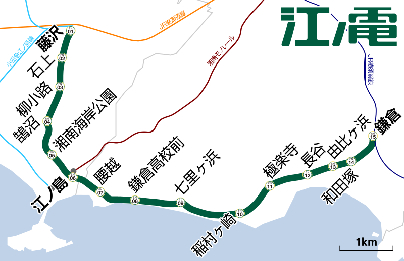
English: Line map of Fujikyuko Line.
日本語: 江ノ島電鉄線・周辺各線の路線図 |
| Date | |
| Source | 国土数値情報・小田急電鉄ニュースリリース[1] |
| Author | Syohei Arai (talk) |
| Permission (Reusing this file) |
This file is licensed under the Creative Commons Attribution 1.0 Generic license.
|
| Other versions | File:EER Linemap en.svg (English version) |
This vector image was created with Adobe Illustrator.
File history
Click on a date/time to view the file as it appeared at that time.
| Date/Time | Thumbnail | Dimensions | User | Comment | |
|---|---|---|---|---|---|
| current | 15:48, 10 May 2014 | | 1,291 × 836 (200 KB) | Araisyohei (talk | contribs) | {{Information |Description={{en|1=Line map of Fujikyuko Line.}} {{ja|1=江ノ島電鉄線・周辺各線の路線図}} |Source=国土数値情報 |Author=<font color=green>Syohei Arai</font> [[:ja:利用者‐会話:Araisyohei|(talk... |
You cannot overwrite this file.
File usage on Commons
The following page uses this file:
File usage on other wikis
The following other wikis use this file: