File:EF1 damage in St. Mary's, Georgia.jpg
Une page de Wikimedia Commons, la médiathèque libre.
Aller à la navigation
Aller à la recherche
- Fichier
- Historique du fichier
- Utilisations locales du fichier
- Utilisations du fichier sur d’autres wikis
- Métadonnées

Taille de cet aperçu : 450 × 600 pixels. Autres résolutions : 180 × 240 pixels | 360 × 480 pixels | 576 × 768 pixels | 768 × 1 024 pixels | 2 448 × 3 264 pixels.
Fichier d’origine (2 448 × 3 264 pixels, taille du fichier : 1,17 Mio, type MIME : image/jpeg)
Informations sur le fichier
Données structurées
Légendes
Légendes
Ajoutez en une ligne la description de ce que représente ce fichier
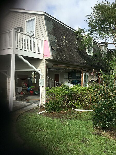
A home in St. Mary, Georgia that sustained EF1 damage from a tornado spawned by Tropical Storm Elsa.
Description
[modifier]| DescriptionEF1 damage in St. Mary's, Georgia.jpg |
English: A home in St. Marys, Georgia that sustained EF1 damage from a tornado spawned by Tropical Storm Elsa on July 7, 2021. (Reference) |
| Date | |
| Source | https://services.dat.noaa.gov/arcgis/rest/services/nws_damageassessmenttoolkit/DamageViewer/FeatureServer/0/2413302/attachments/1486735 |
| Auteur | NWS Jacksonville |
| Lieu de la prise de vue | 30° 43′ 30,83″ N, 81° 32′ 34,21″ O | Voir cet endroit et d’autres images sur : OpenStreetMap |
|---|
Conditions d’utilisation
[modifier]| Public domainPublic domainfalsefalse |
This file is in the public domain in the United States because it was solely created by employees of the National Weather Service or National Severe Storms Laboratory using the Damage Assessment Toolkit (DAT), an interactive map and database.
|
 |
Historique du fichier
Cliquer sur une date et heure pour voir le fichier tel qu'il était à ce moment-là.
| Date et heure | Vignette | Dimensions | Utilisateur | Commentaire | |
|---|---|---|---|---|---|
| actuel | 11 juillet 2021 à 17:35 |  | 2 448 × 3 264 (1,17 Mio) | ChessEric (d | contributions) | Uploaded a work by NWS Jacksonville from https://services.dat.noaa.gov/arcgis/rest/services/nws_damageassessmenttoolkit/DamageViewer/FeatureServer/0/2413302/attachments/1486735 with UploadWizard |
Vous ne pouvez pas remplacer ce fichier.
Utilisations locales du fichier
La page suivante utilise ce fichier :
- File:EF2 damage in St. Mary's, Georgia.jpg (redirection de fichier)
Utilisations du fichier sur d’autres wikis
Les autres wikis suivants utilisent ce fichier :
- Utilisation sur en.wikipedia.org
- Utilisation sur fr.wikipedia.org
Métadonnées
Ce fichier contient des informations supplémentaires, probablement ajoutées par l'appareil photo numérique ou le numériseur utilisé pour le créer.
Si le fichier a été modifié depuis son état original, certains détails peuvent ne pas refléter entièrement l'image modifiée.
| Fabricant de l’appareil photo | Apple |
|---|---|
| Modèle de l’appareil photo | iPad (5th generation) |
| Durée d’exposition | 1/926 s (0,0010799136069114 s) |
| Ouverture focale | f / 2,4 |
| Sensibilité ISO (vitesse d’obturation) | 25 |
| Date et heure de génération des données | 8 juillet 2021 à 08:49 |
| Longueur focale de la lentille | 3,3 mm |
| Latitude | 30° 43′ 30,83″ N |
| Longitude | 81° 32′ 34,21″ W |
| Altitude | 0,216 mètre en dessous du niveau de la mer |
| Largeur | 2 448 px |
| Hauteur | 3 264 px |
| Orientation | Normale |
| Résolution horizontale | 72 pt/po |
| Résolution verticale | 72 pt/po |
| Logiciel utilisé | ArcGIS Survey123 |
| Date de modification du fichier | 8 juillet 2021 à 08:49 |
| Positionnement YCbCr | Centré |
| Programme d’exposition | Programme normal |
| Version d’EXIF | 2.32 |
| Date et heure de la numérisation | 8 juillet 2021 à 08:49 |
| Signification de chaque composante |
|
| Vitesse d’obturation APEX | 9,8547529706066 |
| Ouverture APEX | 2,5260688116622 |
| Luminance APEX | 9,2630109850531 |
| Biais de compensation d’exposition APEX | 0 |
| Mode de mesure | Motif géométrique |
| Flash | Flash non déclenché, Aucune fonction de flash |
| Fractions de secondes de l’horodatage de la prise de vue originale | 690 |
| Fractions de secondes de l’horodatage de la numérisation | 690 |
| Version de FlashPix prise en charge | 1 |
| Espace colorimétrique | sRGB |
| Type de capteur | Capteur de couleur à une puce |
| Type de scène | 0 |
| Mode d’exposition | Exposition automatique |
| Balance des blancs | Balance des blancs automatique |
| Longueur focale pour un film 35 mm | 31 mm |
| Type de capture de la scène | Standard |
| Heure GPS (horloge atomique) | 00:00 |
| Unité de vitesse | Kilomètres à l’heure |
| Vitesse du récepteur GPS | 3,852 |
| Référence pour la direction du mouvement | Vrai nord (géographique) |
| Direction du mouvement | 172,6172 |
| Référence pour la direction de l’image | Nord magnétique |
| Direction de l’image | 252,87 |
| Système géodésique utilisé | WGS-84 |
| Date du GPS | 2021-07-08 |
| Version de la balise GPS | 2.3.0.0 |
Données structurées
Éléments décrits dans ce fichier
dépeint
8 juillet 2021
30°43'30.83"N, 81°32'34.22"W
0.00107991360691144708 seconde
3,3 millimètre
image/jpeg
Catégories cachées :