File:Eagle House, Williamsville, New York - 20200802.jpg
Jump to navigation
Jump to search
Size of this preview: 799 × 599 pixels. Other resolutions: 320 × 240 pixels | 640 × 480 pixels | 1,024 × 768 pixels | 1,280 × 960 pixels | 2,025 × 1,519 pixels.
Original file (2,025 × 1,519 pixels, file size: 916 KB, MIME type: image/jpeg)
Captions
Captions
Add a one-line explanation of what this file represents
Summary[edit]
| Description |
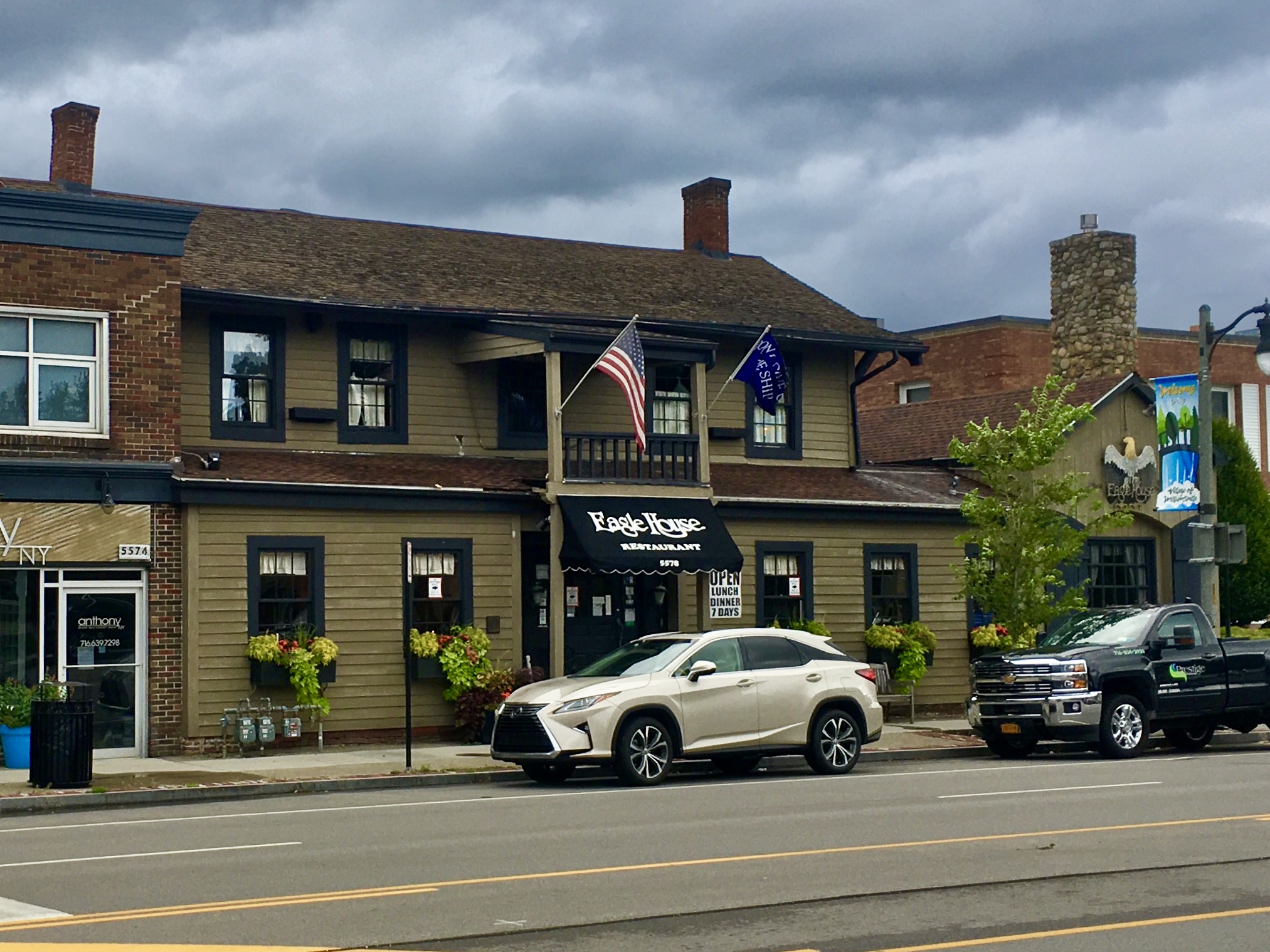
English: Eagle House Tavern, 5578 Main Street, Williamsville, New York, August 2020. One of the most historic structures in all of Williamsville, as well as its oldest continuously operating business, the Eagle House was founded in 1832 by Oziel Smith (1784-1836), a businessman, farmer, and real estate speculator originally from Clarendon, Vermont who was responsible for the construction or operation of many of the village's most important buildings and institutions during its earliest days: the Dodge Mill, the elegant Mansion House, and the Phoenix Hotel are other examples. It was largely thanks to his effervescence that the village was able to pull itself out of the period of economic stagnation in which it spent the 1820s. During its earliest decades, the Eagle House served as a stop on the stagecoach line linking Buffalo to Batavia along the Great Iroquois Trail (now Main Street and Route 5), the venue for the first several meetings of the Amherst Town Board, a polling place for elections, and also, local rumor has it, a stop on the Underground Railroad. The Eagle House boasted eight guest rooms for lodgers passing through the town. The building passed into the hands of Timothy Hopkins several years after Smith's death, and thenceforward to a succession of different owners, each of whom left his own particular mark on the business and the building. However, it was during Norman Rackl's tenure as lessee, beginning in 1958, when restoration of the Eagle House began in earnest. Today, in addition to being a popular bar and restaurant for village residents with an obvious and authentic historic ambience, it's also a designated Village of Williamsville historic landmark. |
| Date | Taken on 2 August 2020, 17:24:35 |
| Source | Own work |
| Author | Andre Carrotflower |
| Camera location | | View this and other nearby images on: OpenStreetMap |
|---|
Licensing[edit]
I, the copyright holder of this work, hereby publish it under the following license:
This file is licensed under the Creative Commons Attribution-Share Alike 4.0 International license.
- You are free:
- to share – to copy, distribute and transmit the work
- to remix – to adapt the work
- Under the following conditions:
- attribution – You must give appropriate credit, provide a link to the license, and indicate if changes were made. You may do so in any reasonable manner, but not in any way that suggests the licensor endorses you or your use.
- share alike – If you remix, transform, or build upon the material, you must distribute your contributions under the same or compatible license as the original.
File history
Click on a date/time to view the file as it appeared at that time.
| Date/Time | Thumbnail | Dimensions | User | Comment | |
|---|---|---|---|---|---|
| current | 03:24, 13 August 2020 | | 2,025 × 1,519 (916 KB) | Andre Carrotflower (talk | contribs) | Uploaded own work with UploadWizard |
You cannot overwrite this file.
File usage on Commons
There are no pages that use this file.
File usage on other wikis
The following other wikis use this file:
- Usage on en.wikipedia.org
Metadata
Categories:
- 2020 in Erie County, New York
- August 2020 in New York (state)
- Restaurants in Erie County, New York
- Wooden buildings in Erie County, New York
- Built in New York (state) in 1832
- 1830s architecture in Erie County, New York
- Federal architecture in Erie County, New York
- Main Street (Williamsville, New York)
- Village of Williamsville, New York Local Landmarks
- Underground Railroad in New York
- Former hotels in New York (state)