File:Earth Impact Database world map.svg
Jump to navigation
Jump to search

Size of this PNG preview of this SVG file: 512 × 256 pixels. Other resolutions: 320 × 160 pixels | 640 × 320 pixels | 1,024 × 512 pixels | 1,280 × 640 pixels | 2,560 × 1,280 pixels.
Original file (SVG file, nominally 512 × 256 pixels, file size: 351 KB)
Captions
Captions
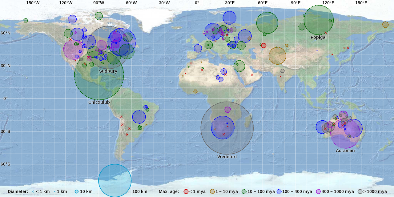
World map of craters on the Earth Impact Database
Summary
[edit]| Description |
English: World map of craters on the Earth Impact Database by CMG Lee. Hover over or tap a circle or cross to highlight it and show its details. Background map is from https://earthquake.usgs.gov/learn/topics/plate_tectonics/majplatecolor.pdf and crater data is from http://passc.net/EarthImpactDatabase/. |
|
| Date | ||
| Source |
|
|
| Author | Cmglee, United States Geological Survey, Earth Impact Database |

Licensing
[edit]
This file is licensed under the Creative Commons Attribution-Share Alike 4.0 International license.
- You are free:
- to share – to copy, distribute and transmit the work
- to remix – to adapt the work
- Under the following conditions:
- attribution – You must give appropriate credit, provide a link to the license, and indicate if changes were made. You may do so in any reasonable manner, but not in any way that suggests the licensor endorses you or your use.
- share alike – If you remix, transform, or build upon the material, you must distribute your contributions under the same or compatible license as the original.
File history
Click on a date/time to view the file as it appeared at that time.
| Date/Time | Thumbnail | Dimensions | User | Comment | |
|---|---|---|---|---|---|
| current | 22:07, 15 July 2018 | | 512 × 256 (351 KB) | Cmglee (talk | contribs) | Support Safari on mobile iOS as per en:user_talk:Vincent_Mia_Edie_Verheyen#Email_questions. |
| 06:36, 1 December 2017 |  | 512 × 256 (359 KB) | Cmglee (talk | contribs) | Label more notable craters and right-align field labels. | |
| 20:53, 13 November 2017 |  | 512 × 256 (345 KB) | Cmglee (talk | contribs) | Use text overlay instead of tooltips. | |
| 08:00, 11 November 2017 |  | 512 × 256 (297 KB) | Cmglee (talk | contribs) | User created page with UploadWizard |
You cannot overwrite this file.
File usage on Commons
There are no pages that use this file.
File usage on other wikis
The following other wikis use this file:
- Usage on ca.wikipedia.org
- Usage on de.wikipedia.org
- Usage on en.wikipedia.org
- Impact crater
- Impact event
- List of impact structures on Earth
- Earth Impact Database
- User:Cmglee
- List of impact structures in Africa
- List of impact structures in Asia and Russia
- List of impact structures in Australia
- List of impact structures in Europe
- List of impact structures in North America
- List of impact structures in South America
- User:Kazkaskazkasako/Books/Physical sciences
- User:Cmglee/svg
- Template:Earth Impact Database world map.svg
- Usage on fa.wikipedia.org
- Usage on fr.wikipedia.org
- Usage on pt.wikipedia.org
- Usage on tr.wikipedia.org
- Usage on zh.wikipedia.org