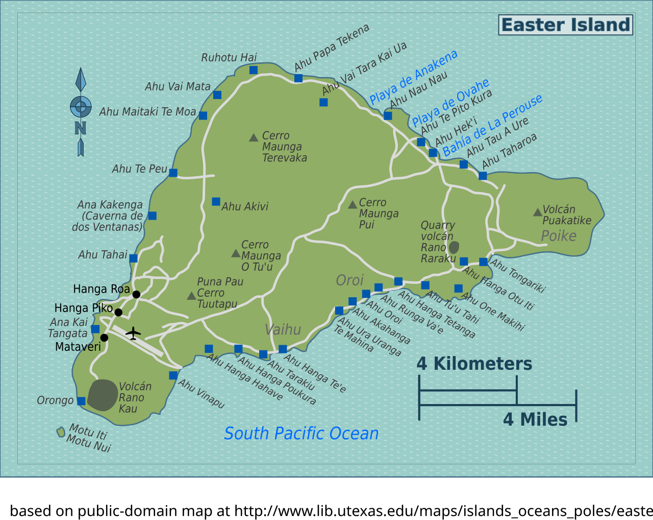
File:Easter Island map.svg
Jump to navigation
Jump to search

Size of this PNG preview of this SVG file: 529 × 420 pixels. Other resolutions: 302 × 240 pixels | 605 × 480 pixels | 967 × 768 pixels | 1,280 × 1,016 pixels | 2,560 × 2,033 pixels.
Original file (SVG file, nominally 529 × 420 pixels, file size: 693 KB)
Captions
Captions
Add a one-line explanation of what this file represents
Summary[edit]
| Description | Map of Easter Island for use on Wikivoyage, multilingual SVG source |
| Date | |
| Source | Own work based on the map of Easter Island |
| Author | Todd VerBee, French translation and amendments by Joelf, Russian translation by Peter Fitzgerald |
| Other versions |
PNG files: |
.png)
.png)
Licensing[edit]
This file is licensed under the Creative Commons Attribution-Share Alike 1.0 Generic license.
- You are free:
- to share – to copy, distribute and transmit the work
- to remix – to adapt the work
- Under the following conditions:
- attribution – You must give appropriate credit, provide a link to the license, and indicate if changes were made. You may do so in any reasonable manner, but not in any way that suggests the licensor endorses you or your use.
- share alike – If you alter, transform, or build upon this work, you must distribute the resulting work under the same license as the original.
Original upload log[edit]
| This file was imported from Wikivoyage WTS. |
The original description page was here. All following user names refer to wts.wikivoyage-old.
- 2009-07-23 04:05 (WT-shared) Peterfitzgerald archive copy at the Wayback Machine 529×420 (626256 bytes) map of Easter Island based on public-domain map at http://www.lib.utexas.edu/maps/islands_oceans_poles/easterisland.jpg © 2006 Todd V (Import from wikitravel.org/shared)
- 2011-10-07 06:40 (WT-shared) Joelf[dead link] 529×420 (700737 bytes) +fr (Import from wikitravel.org/shared)
- 2011-10-09 03:39 (WT-shared) Joelf[dead link] 529×420 (710092 bytes) +Ana Kakenga (Import from wikitravel.org/shared)
File history
Click on a date/time to view the file as it appeared at that time.
| Date/Time | Thumbnail | Dimensions | User | Comment | |
|---|---|---|---|---|---|
| current | 21:35, 22 November 2012 | | 529 × 420 (693 KB) | OgreBot (talk | contribs) | (BOT): Reverting to most recent version before archival |
| 21:35, 22 November 2012 |  | 529 × 420 (684 KB) | OgreBot (talk | contribs) | (BOT): Uploading old version of file from wts.wikivoyage-old; originally uploaded on 2011-10-07 06:40:41 by (WT-shared) Joelf | |
| 21:35, 22 November 2012 |  | 529 × 420 (612 KB) | OgreBot (talk | contribs) | (BOT): Uploading old version of file from wts.wikivoyage-old; originally uploaded on 2009-07-23 04:05:26 by (WT-shared) Peterfitzgerald | |
| 23:32, 17 November 2012 |  | 529 × 420 (693 KB) | MGA73bot2 (talk | contribs) | {{BotMoveToCommons|wts.oldwikivoyage|year={{subst:CURRENTYEAR}}|month={{subst:CURRENTMONTHNAME}}|day={{subst:CURRENTDAY}}}} == {{int:filedesc}} == {{Information |description=map of Easter Island based on public-domain map at http://www.lib.utexas.edu/... |
You cannot overwrite this file.
File usage on Commons
There are no pages that use this file.