File:Edge of Fort Azatlan.jpg
Jump to navigation
Jump to search

Size of this preview: 800 × 600 pixels. Other resolutions: 320 × 240 pixels | 640 × 480 pixels | 1,024 × 768 pixels | 1,280 × 960 pixels | 2,560 × 1,920 pixels | 2,816 × 2,112 pixels.
Original file (2,816 × 2,112 pixels, file size: 3.73 MB, MIME type: image/jpeg)
Captions
Captions
Add a one-line explanation of what this file represents
|
This is an image of a place or building that is listed on the National Register of Historic Places in the United States of America. Its reference number is 75000052. |
| Camera location | | View this and other nearby images on: OpenStreetMap |
|---|
| Description |
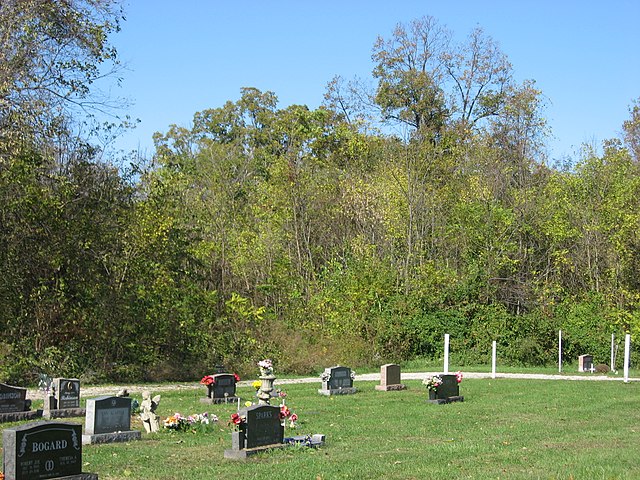
English: Woods in the northwestern corner of the town cemetery of Merom, Indiana, United States. Within the woods is Fort Azatlan, a significant archaeological site; together with the related Merom Site, located under the cemetery, the "fort" is listed on the National Register of Historic Places. |
||
| Date | Taken on 21 October 2011 | ||
| Source | Own work | ||
| Author | Nyttend | ||
| Permission (Reusing this file) |
|
File history
Click on a date/time to view the file as it appeared at that time.
| Date/Time | Thumbnail | Dimensions | User | Comment | |
|---|---|---|---|---|---|
| current | 00:36, 23 October 2011 | | 2,816 × 2,112 (3.73 MB) | Nyttend (talk | contribs) | {{NRHP|75000052}} {{Location|39|3|43|N|87|34|6|W}} {{Information |Description={{en|Woods in the northwestern corner of the town cemetery of {{w|Merom, Indiana|Merom}}, {{w|Indiana}}, {{w|United States}}. Within the woods is {{w|Merom Site and Fort Azatla |
You cannot overwrite this file.
File usage on Commons
There are no pages that use this file.