File:Egypt-12B-021 - Step Pyramid of Djoser (2217505244).jpg

Original file (2,560 × 1,920 pixels, file size: 3.36 MB, MIME type: image/jpeg)
Captions
Captions
Summary[edit]
.jpg&action=edit§ion=1)
| Description |
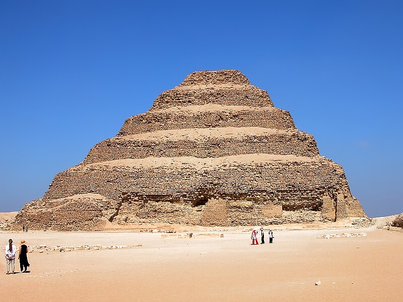
DO NOT SEND ME E-MAIL REQUESTING ME TO LOOK AT A PICTURE, I RETURN ALL COMMENTS IF YOU COMMENT. The Step Pyramid of Djoser is located at Saqqara, just south of Memphis. It started as a mastaba and was expanded six different times to six levels. A mastaba is a type of Ancient Egyptian tomb in the form of a flat-roofed, rectangular structure with outward sloping sides that marked the burial site of many eminent Egyptians of Egypt's ancient period. This pyramid is the earliest stone pyramid in Egypt, thus became an important milestone in Ancient Egyptian Architecture that laid the basis for future and more advanced pyramids in Egypt. The Step Pyramid was already an attraction for many centuries. Evidence has shown that travelers and pilgrims have come to see the pyramid from as early as the Middle Kingdom Period (2040 to 1640 BC). The Step Pyramid of Zoser was built approximately between 2649 to 2575 BC, during the 3rd Dynasty and under the rule of the pharaoh Zoser (or Djoser). The building was under the leadership of the pharaoh’s architect Imhotep. Because of Imhotep’s immense influence and contribution over Ancient Egyptian architecture, he was later deified and became god of the architects and doctors. Special permission from the Antiquities Inspectorate is needed to access the pyramid’s interiors. Original height: 62.198 m (204 ft) Base: 125.27 x 109.11 m (411 x 358 ft) |
| Date | |
| Source | Egypt-12B-021 - Step Pyramid of Djoser |
| Author | Dennis Jarvis from Halifax, Canada |
| Permission (Reusing this file) |
Quote from photographer on numerous files
|
| Camera location | | View this and other nearby images on: OpenStreetMap |
|---|
.jpg¶ms=030.069093_N_0031.247863_E_globe:Earth_type:camera_source:Flickr_&language=en)
Licensing[edit]
.jpg&action=edit§ion=2)
- You are free:
- to share – to copy, distribute and transmit the work
- to remix – to adapt the work
- Under the following conditions:
- attribution – You must give appropriate credit, provide a link to the license, and indicate if changes were made. You may do so in any reasonable manner, but not in any way that suggests the licensor endorses you or your use.
- share alike – If you remix, transform, or build upon the material, you must distribute your contributions under the same or compatible license as the original.
| This image was originally posted to Flickr by archer10 (Dennis) 116M Views at https://flickr.com/photos/22490717@N02/2217505244 (archive). It was reviewed on 1 March 2018 by FlickreviewR 2 and was confirmed to be licensed under the terms of the cc-by-sa-2.0. |
File history
Click on a date/time to view the file as it appeared at that time.
| Date/Time | Thumbnail | Dimensions | User | Comment | |
|---|---|---|---|---|---|
| current | 15:42, 1 March 2018 | | 2,560 × 1,920 (3.36 MB) | Artix Kreiger 2 (talk | contribs) | Transferred from Flickr via Flickr2Commons |
You cannot overwrite this file.
File usage on Commons
There are no pages that use this file.
File usage on other wikis
The following other wikis use this file:
- Usage on ja.wikipedia.org
.jpg&oldid=495068501)