File:Egypt 1450 BC.svg
跳至導覽
跳至搜尋

此 SVG 檔案的 PNG 預覽的大小:520 × 600 像素。 其他解析度:208 × 240 像素 | 416 × 480 像素 | 666 × 768 像素 | 887 × 1,024 像素 | 1,775 × 2,048 像素 | 1,300 × 1,500 像素。
原始檔案 (SVG 檔案,表面大小:1,300 × 1,500 像素,檔案大小:257 KB)
說明
說明
添加單行說明來描述出檔案所代表的內容
摘要
[編輯]| 描述 |
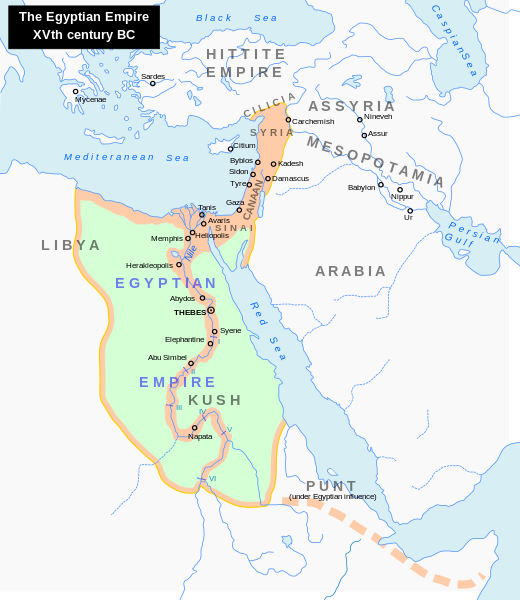
English: Map of the Middle East 1450 BC (by ArdadN)
Čeština: Největší územní rozsah starověkého Egypta, za vlády Thutmose I. |
| 來源 |
The original description page was here. All following user names refer to en.wikipedia.
|
| 作者 | 英文維基百科的ArdadN |
| 其他版本 |
[]
|


|
This SVG file contains embedded text that can be translated into your language, using any capable SVG editor, text editor or the SVG Translate tool. For more information see: About translating SVG files. |
授權條款
[編輯]
| 我,此作品的版權所有人,釋出此作品至公共領域。此授權條款在全世界均適用。 這可能在某些國家不合法,如果是的話: 我授予任何人有權利使用此作品於任何用途,除受法律約束外,不受任何限制。 |
檔案歷史
點選日期/時間以檢視該時間的檔案版本。
| 日期/時間 | 縮圖 | 尺寸 | 用戶 | 備註 | |
|---|---|---|---|---|---|
| 目前 | 2023年9月23日 (六) 22:18 | | 1,300 × 1,500(257 KB) | Gaaryeelidmaan(對話 | 貢獻) | Punt was associated with Myrrh trade, a product found in modern Puntland https://www.worldhistory.org/punt/ |
| 2013年10月9日 (三) 05:28 |  | 1,300 × 1,500(257 KB) | Lymantria(對話 | 貢獻) | Reverted to version as of 00:24, 10 August 2008 | |
| 2013年10月7日 (一) 16:05 |  | 1,300 × 1,500(238 KB) | Emara(對話 | 貢獻) | تعريب الخريطة | |
| 2008年8月10日 (日) 00:24 |  | 1,300 × 1,500(257 KB) | Leoboudv(對話 | 貢獻) | {{Information |Description=Map of the Middle East 1450 BC |Source=The original description page is/was [http://en.wikipedia.org/w/index.php?title=Image%3AEgypt_1450_BC.svg here]. All following user names refer to en.wikipedia. * 2008-05-07 09:18 [[:en:Use |
無法覆蓋此檔案。
檔案用途
下列26個頁面有用到此檔案:
- User:Magog the Ogre/Multilingual legend/2023 September 21-25
- File:Egypt 1400 fKr.svg
- File:Egypt 1450 BC-es.svg
- File:Egypt 1450 BC.svg
- File:Egypt 1450 BC CZ.svg
- File:Egypt 1450 BC ar.svg
- File:Egypt 1450 BC fr.svg
- File:Egypt 1450 BC hr.svg
- File:Egypt 1450 BC mk.svg
- File:Egypt 1450 BC vi.svg
- File:Egypt NK edit-ar.svg
- File:Egypt NK edit-eo.svg
- File:Egypt NK edit-nl.svg
- File:Egypt NK edit-pt.svg
- File:Egypt NK edit-sk.svg
- File:Egypt NK edit-sr.svg
- File:Egypt NK edit-zh-hans.svg
- File:Egypt NK edit.svg
- File:Egypt NK edit es.svg
- File:Egypte 1450 v.Chr.svg
- File:Hitt Egypt 1450 bc-edit1.svg
- File:Hitt Egypt 1450 bc.svg
- File:Hitt Egypt 1450 bc ca.svg
- Template:Other versions/Egypt 15th century BC
- Category:Egyptian New Kingdom
- Category:Land of Punt
全域檔案使用狀況
以下其他 wiki 使用了這個檔案:
- ast.wikipedia.org 的使用狀況
- azb.wikipedia.org 的使用狀況
- az.wikipedia.org 的使用狀況
- ba.wikipedia.org 的使用狀況
- be.wikipedia.org 的使用狀況
- bg.wikipedia.org 的使用狀況
- bn.wikipedia.org 的使用狀況
- ca.wikipedia.org 的使用狀況
- cv.wikipedia.org 的使用狀況
- de.wikipedia.org 的使用狀況
- el.wikipedia.org 的使用狀況
- en.wikipedia.org 的使用狀況
- Timeline of Jerusalem
- Thutmose I
- The Bible Unearthed
- List of conflicts in Asia
- Middle Eastern empires
- Land of Punt
- Transjordan (region)
- List of conflicts in Sudan
- List of conflicts in Libya
- Talk:The Exodus/Archive 18
- User:SomeGuyWhoRandomlyEdits/List of conflicts in the Near East
- User:Falcaorib/Ancient Empires (4000-550 BC)
- eu.wikipedia.org 的使用狀況
- fa.wikipedia.org 的使用狀況
- gl.wikipedia.org 的使用狀況
- hi.wikipedia.org 的使用狀況
- hy.wikipedia.org 的使用狀況
- hyw.wikipedia.org 的使用狀況
- id.wikipedia.org 的使用狀況
- id.wikibooks.org 的使用狀況
- is.wikipedia.org 的使用狀況
- it.wikipedia.org 的使用狀況
- ja.wikipedia.org 的使用狀況
檢視此檔案的更多全域使用狀況。