File:Ele 2002-09-02 2310Z.jpg
跳转到导航
跳转到搜索

本预览的尺寸:463 × 599像素。 其他分辨率:185 × 240像素 | 371 × 480像素 | 593 × 768像素 | 791 × 1,024像素 | 1,582 × 2,048像素 | 6,800 × 8,800像素。
原始文件 (6,800 × 8,800像素,文件大小:8.48 MB,MIME类型:image/jpeg)
说明
说明
添加一行文字以描述该文件所表现的内容
| 警告 | 部分浏览器在浏览此图片的完整大小时可能会遇到困难:该图片中有数量巨大的像素点,可能无法完全载入或者导致您的浏览器停止响应。 |
|---|
摘要
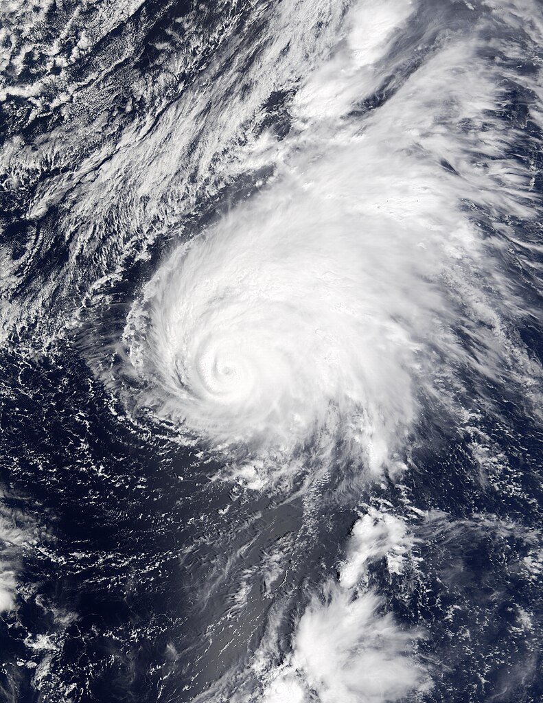
[编辑]| 描述 | Hurricane Ele became Typhoon Ele as it crossed the International Date Line over the Labor Day weekend. The typhoon/hurricane can be seen in the central Pacific in this series of true-color images taken between August 30 and September 7, 2002, by the Moderate Resolution Imaging Spectroradiometer (MODIS) instruments aboard NASA’s Aqua and Terra spacecrafts. As of September 4, the typhoon was several hundred miles east of the International Date Line and making its way north through the Pacific, packing sustained winds of up to 92 miles (148 kilometers) per hour. The hurricane is expected to change direction and move northwest before dropping in intensity and turning into a tropical storm. | |||||
| 日期 | ||||||
| 来源 | http://visibleearth.nasa.gov/view_rec.php?id=3667 | |||||
| 作者 | Jacques Descloitres, MODIS Land Rapid Response Team, NASA/GSFC | |||||
| 授权 (二次使用本文件) |
|
|||||
| 其他版本 | Image:Typhoon Ele 02 sept 2002.jpg |

文件历史
点击某个日期/时间查看对应时刻的文件。
| 日期/时间 | 缩略图 | 大小 | 用户 | 备注 | |
|---|---|---|---|---|---|
| 当前 | 2006年11月12日 (日) 17:17 | | 6,800 × 8,800(8.48 MB) | Good kitty(留言 | 贡献) | == Summary == {{Information |Description=Hurricane Ele became Typhoon Ele as it crossed the International Date Line over the Labor Day weekend. The typhoon/hurricane can be seen in the central Pacific in this series of true-color images taken between Augu |
您不可以覆盖此文件。
文件用途
以下页面使用本文件:
全域文件用途
以下其他wiki使用此文件:
- en.wikipedia.org上的用途
- ko.wikipedia.org上的用途
- th.wikipedia.org上的用途
- zh.wikipedia.org上的用途