File:Endurance fr.svg
跳转到导航
跳转到搜索

此SVG文件的PNG预览的大小:675 × 600像素。 其他分辨率:270 × 240像素 | 540 × 480像素 | 864 × 768像素 | 1,152 × 1,024像素 | 2,304 × 2,048像素 | 900 × 800像素。
原始文件 (SVG文件,尺寸为900 × 800像素,文件大小:98 KB)
说明
说明
添加一行文字以描述该文件所表现的内容
| 描述 |
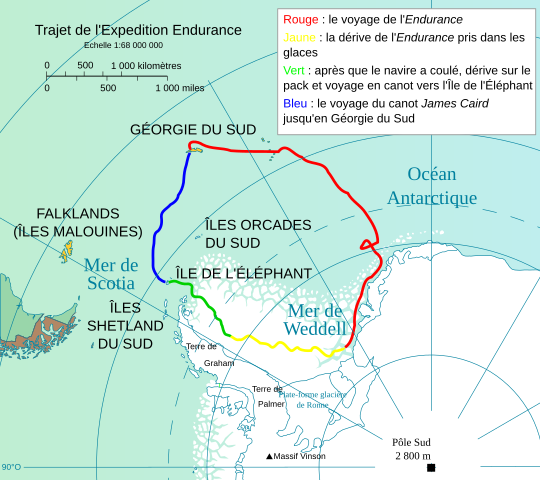
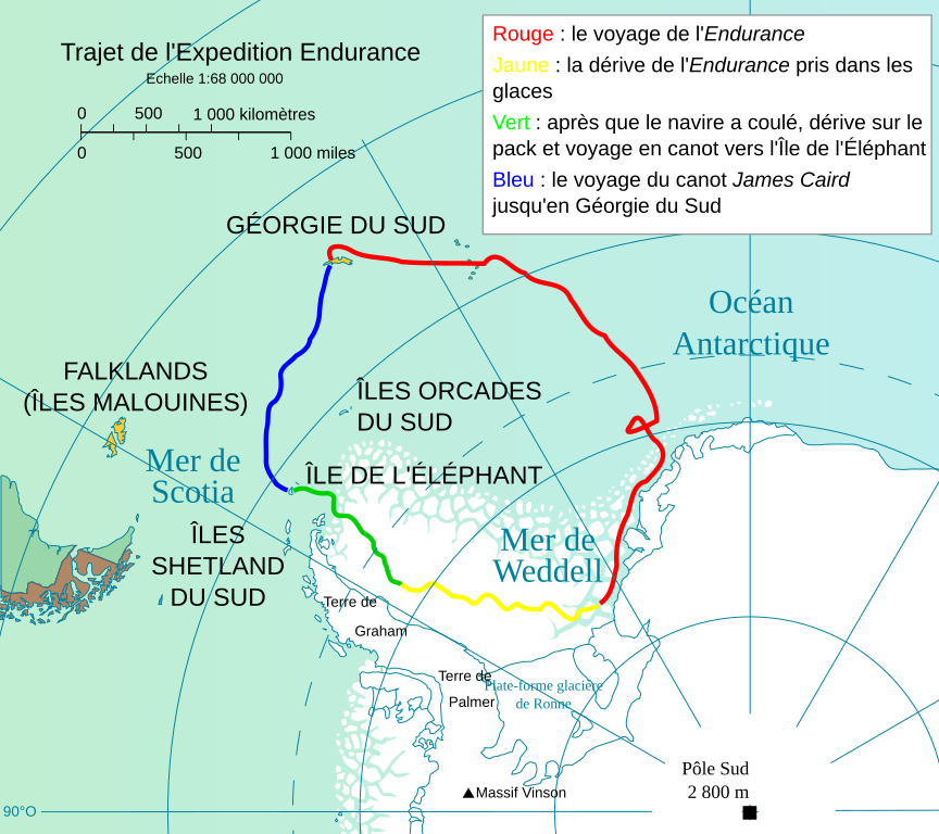
Français : Trajet de l'Expédition Endurance, quatrième expédition brittanique en Antarctique au XXème siècle.
English: Route of Imperial Trans-Antarctic Expedition (with the ship Endurance), fourth english expedition in XX century in Antarctic. PLAN KEY : Red : The Endurance 's route. Yellow : drift of the Endurance jammed in ice. Green : After the shipwreck under ices, drift on ice field, and journey with canot towards Elephant isle. Blue : dinghy James Caird's route towards South Georgia.
Deutsch: Fahrt von die de:Expedition Endurance, vierte brittanischen Spedition nach Antarktis im 20. Jahrhundert. LEGENDE : Rot : die Reise der Endurance. Gelb : das Abdriften von Endurance, in den Spiegeln. Grün: nachdem das Schiff geflossen ist, abdrift auf Packeis, und Reise nach dem Boot zur Insel des Elefanten. Blau: die Reise des Bootes Jamesz Caird bis südliches Georgien.
Español: Viaje de la Expedición Endurance (Expedición Imperial Trans-Antártica), que es la cuarta expedición inglesa en el siglo 20. PIE : Rojo: el viaje del Endurance. Amarillo: flujo de la Endurance atestada en hielo. Verde : Después del naufragio en hielos, vaya a la deriva sobre el campo de hielo, y el viaje con barcas hacia la isla de Elefante. Azul: : viaje con el James Caird hacia la Georgia del sul.
Italiano: Cf. Spedizione Endurance. Rosso: La Endurance percorso. Giallo: moto della Endurance si bloccò in ghiaccio. Verde : Dopo il naufragio sotto ghiacci, vada alla deriva su campo di ghiaccio, e viaggi con canotti verso isola di Elefante. Blu : percorso del canotto James Caird. |
| 日期 | |
| 来源 |
自己的作品 Image:James caird voyage1.PNG + Image:Antarctic fr.svg + Image:ShackletonEnduranceCarte.png |
| 作者 | Bourrichon |
| 授权 (二次使用本文件) |
本文件采用知识共享署名-相同方式共享 3.0 未本地化版本许可协议授权。
|
| 其他版本 |
|


|
This SVG file contains embedded text that can be translated into your language, using any capable SVG editor, text editor or the SVG Translate tool. For more information see: About translating SVG files. |
W3C-validity not checked.
文件历史
点击某个日期/时间查看对应时刻的文件。
| 日期/时间 | 缩略图 | 大小 | 用户 | 备注 | |
|---|---|---|---|---|---|
| 当前 | 2016年11月24日 (四) 12:16 | | 900 × 800(98 KB) | Jc86035(留言 | 贡献) | "Îles Orcades" → "Îles Orcades du Sud" |
| 2015年11月11日 (三) 06:21 |  | 900 × 800(98 KB) | Odysseus1479(留言 | 贡献) | Corriger (intervertir) mi. et km | |
| 2014年5月28日 (三) 13:32 |  | 900 × 800(98 KB) | Jc86035(留言 | 贡献) | Fixed the accent on "Géorgie du Sud" | |
| 2014年5月28日 (三) 10:12 |  | 900 × 800(98 KB) | Jc86035(留言 | 贡献) | Fixed a few errors | |
| 2014年5月27日 (二) 16:26 |  | 900 × 800(98 KB) | Jc86035(留言 | 贡献) | Changed fonts to those that render, cleaned up | |
| 2008年4月17日 (四) 09:03 |  | 900 × 800(167 KB) | Actam(留言 | 贡献) | Fixed raster image, fixed paths (used lines instead of fills), svg cleanup (really really needed it!) Used all open fonts (no Arial, font not supported!) | |
| 2008年3月28日 (五) 17:19 |  | 900 × 800(2.03 MB) | Bourrichon(留言 | 贡献) | {{Information |Description= {{fr|Trajet de l'Expédition ''Endurance'', quatrième expédition brittanique en Antarctique au XXème siècle.}} {{en|Route of [[:en:Imperial Trans-Antarctic Expedition|Imperial Trans-Antarctic E |
您不可以覆盖此文件。
文件用途
以下10个页面使用本文件:
- User:4ing/Antarctica/2015-11
- User:4ing/Antarctica/2016-11
- User:Chumwa/OgreBot/Potential transport maps/2016 November 21-30
- User:Chumwa/OgreBot/Transport Maps/2015 November 11-20
- User:Chumwa/OgreBot/Transport Maps/2016 November 21-30
- User:Chumwa/OgreBot/Travel and communication maps/2016 November 21-30
- Commons:Graphic Lab/Map workshop/Archive/2016
- File:Endurance.svg(文件重定向)
- File:Endurance en.svg
- File:James Caird fr.svg
全域文件用途
以下其他wiki使用此文件:
- fr.wikipedia.org上的用途
- zh.wikipedia.org上的用途