File:Europe HSR density1.svg
Jump to navigation
Jump to search

Size of this PNG preview of this SVG file: 800 × 557 pixels. Other resolutions: 320 × 223 pixels | 640 × 445 pixels | 1,024 × 712 pixels | 1,280 × 890 pixels | 2,560 × 1,781 pixels | 1,150 × 800 pixels.
Original file (SVG file, nominally 1,150 × 800 pixels, file size: 729 KB)
Captions
Captions
Add a one-line explanation of what this file represents
Summary[edit]
| Description |
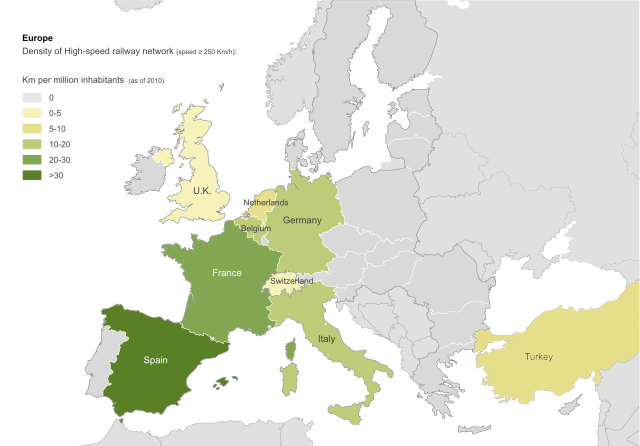
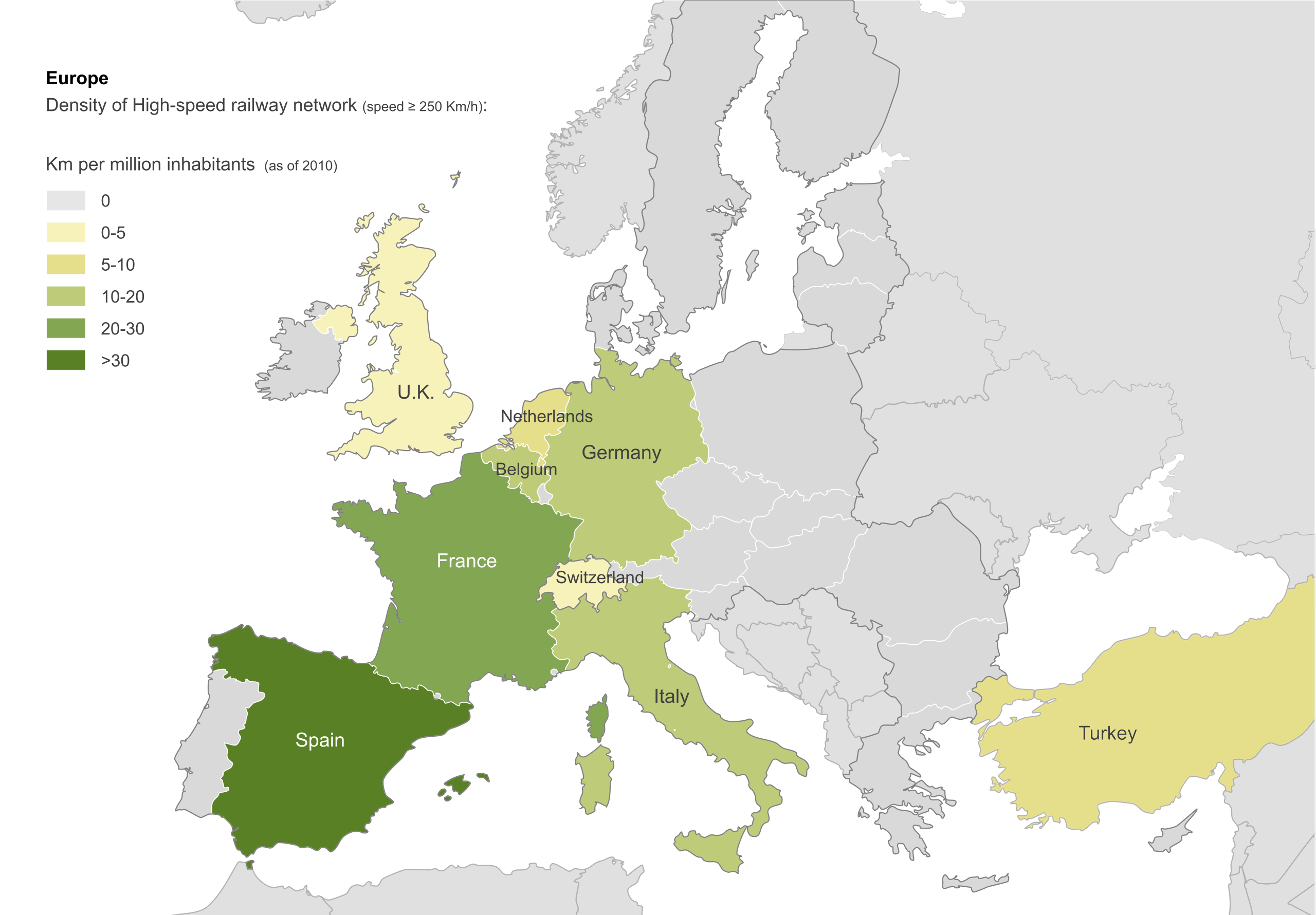
Density of High-speed railway network in Europe (speed ≥ 250 Km/h). Km per million inhabitants (as of 2010). |
| Date | |
| Source | own work on File:Blank_map_of_Europe.svg |
| Author | Antschaser |
| Other versions | Español: File: Europa densidad alta velocidad.svg; Français: File:Europe densité LGV.svg |
Licensing[edit]
I, the copyright holder of this work, hereby publish it under the following licenses:

|
Permission is granted to copy, distribute and/or modify this document under the terms of the GNU Free Documentation License, Version 1.2 or any later version published by the Free Software Foundation; with no Invariant Sections, no Front-Cover Texts, and no Back-Cover Texts. A copy of the license is included in the section entitled GNU Free Documentation License. |
This file is licensed under the Creative Commons Attribution-Share Alike 4.0 International, 3.0 Unported, 2.5 Generic, 2.0 Generic and 1.0 Generic license.
- You are free:
- to share – to copy, distribute and transmit the work
- to remix – to adapt the work
- Under the following conditions:
- attribution – You must give appropriate credit, provide a link to the license, and indicate if changes were made. You may do so in any reasonable manner, but not in any way that suggests the licensor endorses you or your use.
- share alike – If you remix, transform, or build upon the material, you must distribute your contributions under the same or compatible license as the original.
You may select the license of your choice.
File history
Click on a date/time to view the file as it appeared at that time.
| Date/Time | Thumbnail | Dimensions | User | Comment | |
|---|---|---|---|---|---|
| current | 20:33, 31 July 2012 | | 1,150 × 800 (729 KB) | Antschaser (talk | contribs) | Reverted to version as of 11:05, 9 September 2011: new countries added have not HSR over 250km, wich is the used criteria. If you change criteria, you should do another map adding lines with those characteristics for all the countries. |
| 12:36, 18 July 2012 |  | 2,000 × 1,391 (755 KB) | Nicksss93 (talk | contribs) | Sweden added. | |
| 16:31, 16 July 2012 |  | 2,000 × 1,391 (747 KB) | Nicksss93 (talk | contribs) | Kaliningrad added. | |
| 16:23, 16 July 2012 |  | 2,000 × 1,391 (747 KB) | Nicksss93 (talk | contribs) | Map updated - Austria, Poland and Russia added. | |
| 17:50, 1 July 2012 |  | 1,150 × 800 (261 KB) | Nicksss93 (talk | contribs) | Bulgaria added. | |
| 11:05, 9 September 2011 |  | 1,150 × 800 (729 KB) | Emturan (talk | contribs) | In Turkey, new lines open to revenue services. Total line lenght: 457 km, Population. 73.72 million. Density:6.2 | |
| 09:24, 9 September 2011 |  | 1,150 × 800 (624 KB) | Emturan (talk | contribs) | Reverted to version as of 18:51, 23 October 2010 | |
| 09:20, 9 September 2011 |  | 1,150 × 800 (624 KB) | Emturan (talk | contribs) | New lines open to revenue services. Total line lenght: 457 km, Population. 73.72 million | |
| 18:51, 23 October 2010 |  | 1,150 × 800 (624 KB) | Antschaser (talk | contribs) | adding background | |
| 18:14, 23 October 2010 |  | 1,150 × 800 (625 KB) | Antschaser (talk | contribs) | fonts |
You cannot overwrite this file.
File usage on Commons
There are no pages that use this file.
File usage on other wikis
The following other wikis use this file:
- Usage on en.wikipedia.org
- Usage on eu.wikipedia.org
- Usage on th.wikipedia.org