File:Evacuation stairway at the Omoto Elementary School.jpg
Jump to navigation
Jump to search
Size of this preview: 799 × 600 pixels. Other resolutions: 320 × 240 pixels | 640 × 480 pixels | 894 × 671 pixels.
Original file (894 × 671 pixels, file size: 112 KB, MIME type: image/jpeg)
Captions
Captions
Add a one-line explanation of what this file represents
Summary[edit]
| Description |
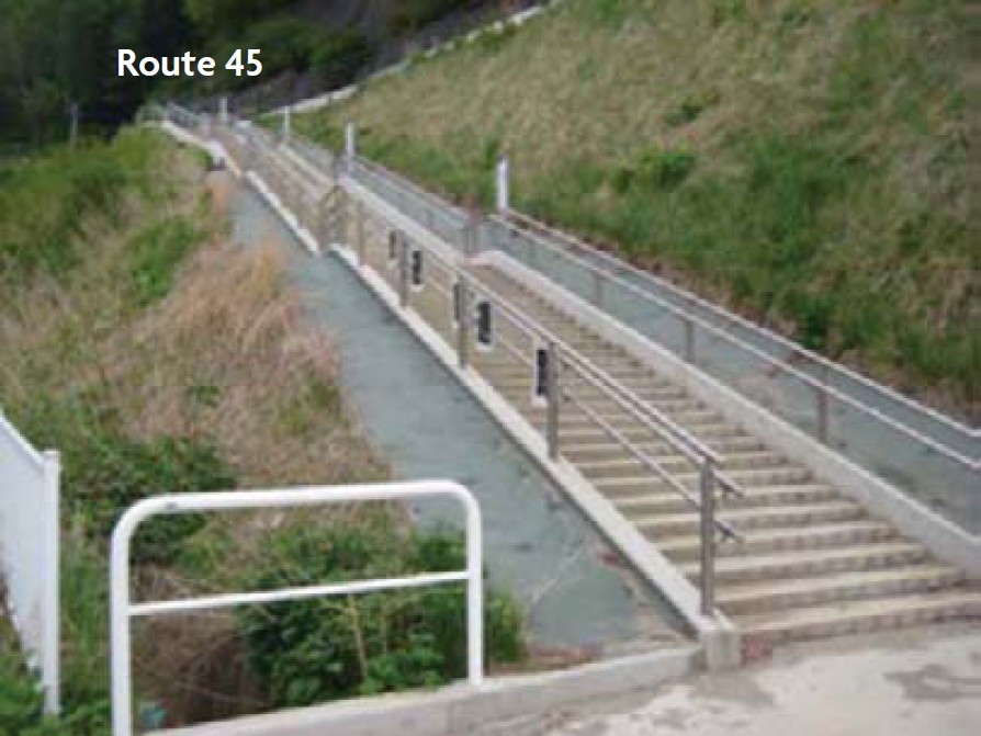
English: Source: Junko Sagara: "Multifunctional Infrastructure", in: Federica Ranghieri, Mikio Ishiwatari (editors): Learning from Megadisasters - Lessons from the Great East Japan Earthquake, World Bank Publications, Washington, DC, 2014, ISBN (paper): 978-1-4648-0153-2, ISBN (electronic): 978-1-4648-0154-9, DOI: 10.1596/978-1-4648-0153-2, Chapter 4, pp. 49-53, here: p. 51, Figure 4.4 "Evacuation stairway at the Omoto Elementary School - Source: MLIT.". License: Creative Commons Attribution CC BY 3.0 IGO.
Context as given in the above cited source: "Evacuation stairs to expressways saved school children When Iwaizumi Town in the Iwate Prefecture was severely hit by the massive tsunami, an evacuation stairway constructed at the Omoto Elementary School two years before saved the lives of 88 children (fi gure 4.4). Because there was no escape route from the school, since it was surrounded by steep cliffs, some of the children suggested how improvements might be made during a tsunami evacuation drill. In response to their suggestions and those of local residents, a MLIT field office completed the approximately 30-meter evacuation stairway with 130 steps along Route 45, which runs right behind the school." |
| Date | |
| Source | Junko Sagara: "Multifunctional Infrastructure", in: Federica Ranghieri, Mikio Ishiwatari (editors): Learning from Megadisasters - Lessons from the Great East Japan Earthquake, World Bank Publications, Washington, DC, 2014, ISBN (paper): 978-1-4648-0153-2, ISBN (electronic): 978-1-4648-0154-9, DOI: 10.1596/978-1-4648-0153-2, Chapter 4, pp. 49-53, here: p. 51, Figure 4.4 "Evacuation stairway at the Omoto Elementary School - Source: MLIT.". License: Creative Commons Attribution CC BY 3.0 IGO. |
| Author | (Japanese) Ministry of Land, Infrastructure, Transport and Tourism (MLIT) |
| Permission (Reusing this file) |
This file is licensed under the Creative Commons Attribution 3.0 IGO license.
|
| Camera location | | View this and other nearby images on: OpenStreetMap |
|---|
File history
Click on a date/time to view the file as it appeared at that time.
| Date/Time | Thumbnail | Dimensions | User | Comment | |
|---|---|---|---|---|---|
| current | 17:54, 5 August 2018 | | 894 × 671 (112 KB) | Anglo-Araneophilus~commonswiki (talk | contribs) | {{Information |description ={{en|1=Source: Junko Sagara: "Multifunctional Infrastructure", in: Federica Ranghieri, Mikio Ishiwatari (editors): Learning from Megadisasters - Lessons from the Great East Japan Earthquake, World Bank Publications, Washington, DC, 2014, ISBN (paper): 978-1-4648-0153-2, ISBN (electronic): 978-1-4648-0154-9, DOI: 10.1596/978-1-4648-0153-2, Chapter 4, pp. 49-53, here: p. 51, Figure 4.4 "Evacuation stairway at the Omoto Elementary School - Source: MLIT.". License: C... |
You cannot overwrite this file.
File usage on Commons
There are no pages that use this file.
File usage on other wikis
The following other wikis use this file:
- Usage on de.wikipedia.org