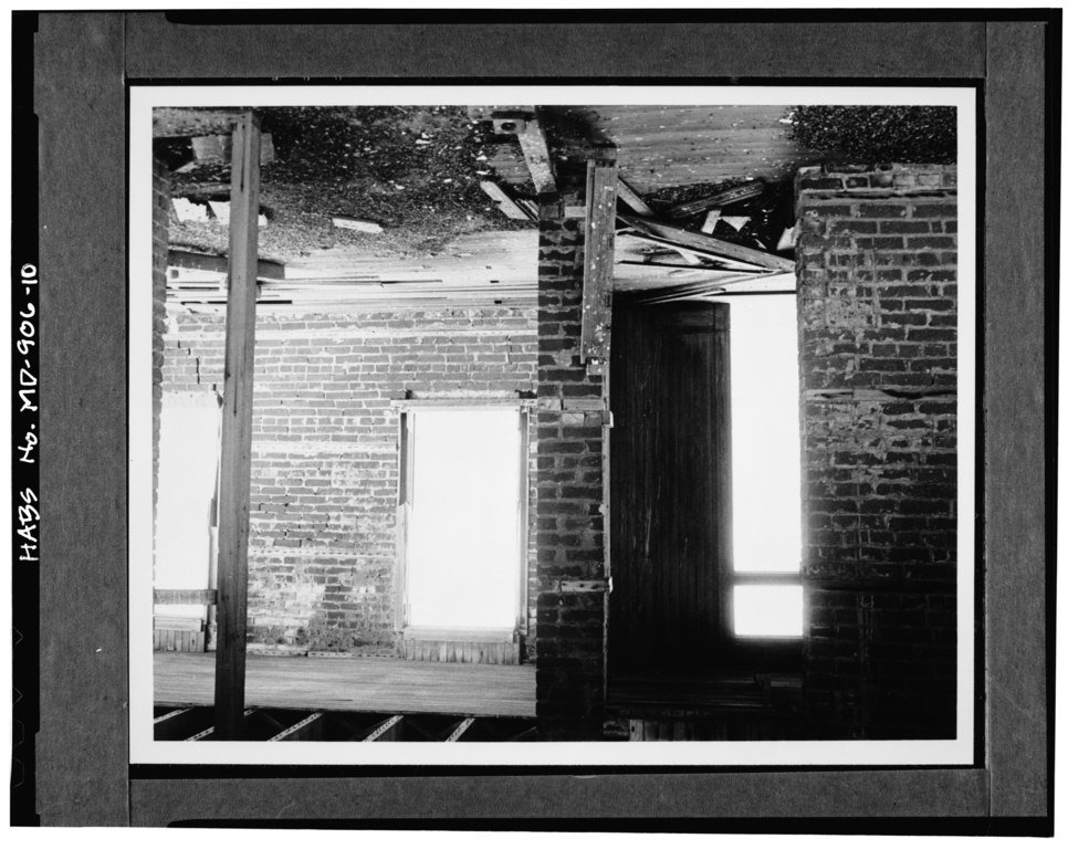
File:FIRST FLOOR, BRICK WALLS, DOOR AND WINDOW OPENINGS, LOOKING NORTHEAST - Cedar Point Lighthouse, Cedar Point at Patuxent River and Chesapeake Bay, Lexington Park, St. Mary's HABS MD,19-LEXP.V,1-10.tif
Jump to navigation
Jump to search

Size of this JPG preview of this TIF file: 754 × 600 pixels. Other resolutions: 302 × 240 pixels | 604 × 480 pixels | 966 × 768 pixels | 1,280 × 1,018 pixels | 2,560 × 2,035 pixels | 4,939 × 3,927 pixels.
Original file (4,939 × 3,927 pixels, file size: 18.5 MB, MIME type: image/tiff)
Captions
Captions
Add a one-line explanation of what this file represents
Summary[edit]
| FIRST FLOOR, BRICK WALLS, DOOR AND WINDOW OPENINGS, LOOKING NORTHEAST - Cedar Point Lighthouse, Cedar Point at Patuxent River and Chesapeake Bay, Lexington Park, St. Mary's County, MD
( |
||||||||||||||||||||||||
|---|---|---|---|---|---|---|---|---|---|---|---|---|---|---|---|---|---|---|---|---|---|---|---|---|
| Title |
FIRST FLOOR, BRICK WALLS, DOOR AND WINDOW OPENINGS, LOOKING NORTHEAST - Cedar Point Lighthouse, Cedar Point at Patuxent River and Chesapeake Bay, Lexington Park, St. Mary's County, MD |
|||||||||||||||||||||||
| Description |
English: Toy, Benjamin F; Chesapeake Division, Naval Facilities Engineering Command, photographer; Earle, Lawrence P, historian |
|||||||||||||||||||||||
| Depicted place | Maryland; St. Mary's County; Lexington Park | |||||||||||||||||||||||
| Date | Documentation compiled after 1933 | |||||||||||||||||||||||
| Dimensions | 4 x 5 in. | |||||||||||||||||||||||
| Collection |
|
|||||||||||||||||||||||
| Current location |
Library of Congress Prints and Photographs Division Washington, D.C. 20540 USA http://hdl.loc.gov/loc.pnp/pp.print |
|||||||||||||||||||||||
| Accession number |
HABS MD,19-LEXP.V,1-10 |
|||||||||||||||||||||||
| Credit line |
|
|||||||||||||||||||||||
| Notes |
|
|||||||||||||||||||||||
| Source | https://www.loc.gov/pictures/item/md1021.photos.083967p | |||||||||||||||||||||||
| Permission (Reusing this file) |
|
|||||||||||||||||||||||


| Object location | | View this and other nearby images on: OpenStreetMap |
|---|
File history
Click on a date/time to view the file as it appeared at that time.
| Date/Time | Thumbnail | Dimensions | User | Comment | |
|---|---|---|---|---|---|
| current | 20:24, 22 July 2014 |  | 4,939 × 3,927 (18.5 MB) | Fæ (talk | contribs) | GWToolset: Creating mediafile for Fæ. HABS 21 July 2014 (1601:1800) |
You cannot overwrite this file.
File usage on Commons
The following page uses this file: