File:Florida-Pensacola-map-legend-X-6-1756-FAA.gif
Jump to navigation
Jump to search
No higher resolution available.
Florida-Pensacola-map-legend-X-6-1756-FAA.gif (475 × 400 pixels, file size: 16 KB, MIME type: image/gif)
Captions
Captions
Add a one-line explanation of what this file represents
Summary[edit]
| Description |
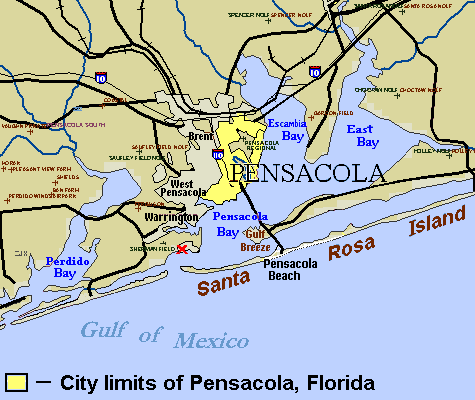
English: City map of Pensacola, with city limits marked by legend (see References maps). The site of the first settlement near Pensacola (Ochuse) is marked by the red "X" near the site of Fort Barrancas. Small crosses designate airfields in the region. Areas have been labeled for the communities of Brent, West Pensacola, Warrington, Gulf Breeze, and Pensacola Beach. (Several other towns have not been labeled.) |
| Source |
(Original text: Source URL (U.S. Government FAA): http://tfr.faa.gov/save_maps/map_6_1756.gif (Airfield map trimmed/edited to set Pensacola city limits, label "Santa Rosa Island" (below site marked "X") plus Interstate-10/110 icons, "Pensacola Bay" and other bays). The file is in GIF format, which can be edited in detail without loss of colors. References
|
| Author |
Licensing[edit]
This image or file is a work of a Federal Aviation Administration employee, taken or made as part of that person's official duties. As a work of the U.S. federal government, the image is in the public domain in the United States.
|
 |
Original upload log[edit]
The original description page was here. All following user names refer to en.wikipedia.
| Date/Time | Dimensions | User | Comment |
|---|---|---|---|
| 2007-07-31 16:42 | 475×400× (16590 bytes) | Wikid77 | Map width cropped 21% to enlarge labels 21%. Added "Pensacola Beach" & enlarged "Warrington" with I-10 icons. |
| 2007-07-29 13:41 | 600×455× (19615 bytes) | Wikid77 | Reduced Pensacola city limits (see reference maps), icons I-10/110, labeled [[Brent, FL|Brent]], [[Warrington, FL|Warrington]], "[[West Pensacola, FL|West Pensacola]]" & Gulf Breeze. |
| 2007-01-12 04:25 | 600×455× (18935 bytes) | Wikid77 | City map of [[Pensacola, Florida]], with city limits marked by legend. The site of the [[History of Pensacola, Florida|first settlement]] of Pensacola (''Ochuse'') is marked by the red "X" at the site of [[Fort Barrancas]]. Small crosses designate airfie |
| 2007-01-11 20:23 | 600×470× (18863 bytes) | Wikid77 | City map of [[Pensacola, Florida]], with city limits marked by legend. The site of the [[History of Pensacola, Florida|first settlement]] of Pensacola (''Ochuse'') is marked by the red "X" at the site of [[Fort Barrancas]]. Small crosses designate airfie |
File history
Click on a date/time to view the file as it appeared at that time.
| Date/Time | Thumbnail | Dimensions | User | Comment | |
|---|---|---|---|---|---|
| current | 08:48, 6 October 2014 | | 475 × 400 (16 KB) | Urdangaray (talk | contribs) | Transferred from en.wikipedia |
You cannot overwrite this file.
File usage on Commons
The following page uses this file:
File usage on other wikis
The following other wikis use this file:
- Usage on en.wikipedia.org
- Usage on es.wikipedia.org
- Usage on ja.wikipedia.org