File:Frankfurt am Main - Netzplan Schienennahverkehr (einfach).png
Jump to navigation
Jump to search
Size of this preview: 800 × 574 pixels. Other resolutions: 320 × 230 pixels | 640 × 459 pixels | 1,024 × 735 pixels | 1,280 × 918 pixels | 2,537 × 1,820 pixels.
Original file (2,537 × 1,820 pixels, file size: 1.26 MB, MIME type: image/png)
Captions
Captions
Add a one-line explanation of what this file represents
Summary
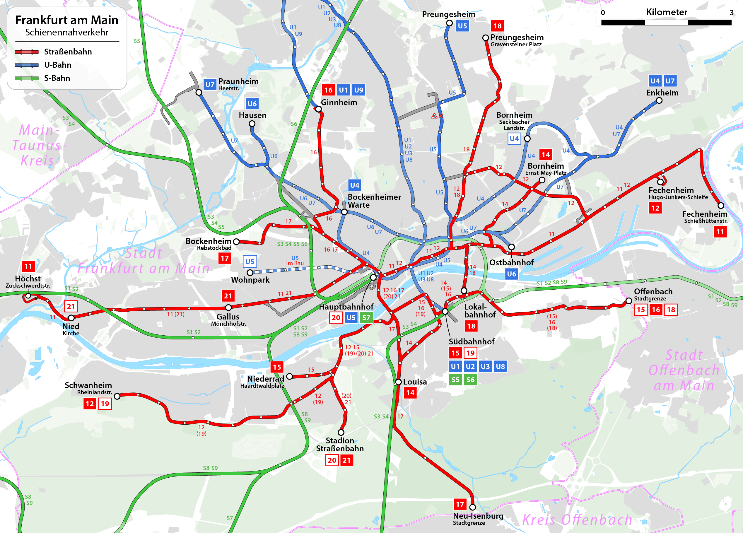
[edit]| Description |
|
| Date | see file history |
| Source | Own work, using OpenStreetMap data for the background |
| Author | Maximilian Dörrbecker (Chumwa) |
| Permission (Reusing this file) |
All OpenStreetMap data and maps are Creative Commons "CC-BY-SA 2.0" licensed This file is licensed under the Creative Commons Attribution-Share Alike 2.0 Generic license.
|
| Other versions |
|

.png)


.png&action=edit§ion=1)

|
This transport map image could be re-created using vector graphics as an SVG file. This has several advantages; see Commons:Media for cleanup for more information. If an SVG form of this image is available, please upload it and afterwards replace this template with
{{vector version available|new image name}}.
It is recommended to name the SVG file “Frankfurt am Main - Netzplan Schienennahverkehr (einfach).svg”—then the template Vector version available (or Vva) does not need the new image name parameter. |
File history
Click on a date/time to view the file as it appeared at that time.
| Date/Time | Thumbnail | Dimensions | User | Comment | |
|---|---|---|---|---|---|
| current | 14:00, 5 January 2019 | | 2,537 × 1,820 (1.26 MB) | Chumwa (talk | contribs) | Streckentausch U6 ←→ U7 |
| 16:37, 5 October 2017 |  | 2,537 × 1,820 (1.26 MB) | Chumwa (talk | contribs) | Planungen wieder herausgenommen | |
| 17:39, 4 October 2017 |  | 2,537 × 1,820 (1.26 MB) | Chumwa (talk | contribs) | Aktualisierung | |
| 05:18, 17 December 2014 |  | 2,537 × 1,820 (1.25 MB) | Chumwa (talk | contribs) | corr | |
| 04:35, 15 December 2014 |  | 2,537 × 1,820 (1.25 MB) | Chumwa (talk | contribs) | Lieschen raus, Gallus Süd nur noch Betriebsstrecke | |
| 19:52, 14 December 2014 |  | 2,537 × 1,820 (1.26 MB) | Chumwa (talk | contribs) | Fahrplanwechsel 14.12.2014 | |
| 19:58, 25 December 2011 |  | 2,537 × 1,820 (1.21 MB) | Chumwa (talk | contribs) | {{Information |Description= *{{ de }} Netzplan der Straßenbahn Frankfurt am Main *{{ en }} Map of the Frankfurt tramway system *{{ fr }} Plan de réseau du tramway de Francfort-sur-le-Main |Author=Maximilian Dörrbecker ([[:de:User:Ch |
You cannot overwrite this file.
File usage on Commons
The following 16 pages use this file:
- Straßenbahn Frankfurt am Main
- Top 200 transport map images that should use vector graphics
- Verkehr in Frankfurt am Main
- User:Chumwa/Gallery
- User:Chumwa/OgreBot/Potential transport maps/2017 October 1-10
- User:Chumwa/OgreBot/Potential transport maps/2019 January 1-10
- User:Chumwa/OgreBot/Public transport information/2017 October 1-10
- User:Chumwa/OgreBot/Public transport information/2019 January 1-10
- User:Chumwa/OgreBot/Transport Maps/2017 October 1-10
- User:Chumwa/OgreBot/Transport Maps/2019 January 1-10
- User:Chumwa/OgreBot/Travel and communication maps/2017 October 1-10
- User:Chumwa/OgreBot/Travel and communication maps/2019 January 1-10
- File:Frankfurt am Main - Netzplan Schienennahverkehr.png
- File:Frankfurt am Main - Netzplan Schienennahverkehr (einfach).png
- File:Frankfurt am Main - Streckenführung der geplanten Regionaltangente West.png
- File:Frankfurt am Main - Streckenführung der geplanten Ringstraßenbahn.png
File usage on other wikis
The following other wikis use this file:
- Usage on de.wikipedia.org
- Straßenbahn Frankfurt am Main
- Vorlage:Infobox Straßenbahnsystem
- Vorlage:Infobox Straßenbahnsystem/Doku
- Wikipedia:Kartenwerkstatt/Archiv/2012-01
- Wikipedia:Kartenwerkstatt/Archiv/2014-12
- Wikipedia:Auskunft/Archiv/2015/Woche 51
- Wikipedia:Kartenwerkstatt/Archiv/2017-10
- Benutzer Diskussion:Chumwa/Archiv/2021/1. Quartal
- U-Bahnhof Güterplatz
- Usage on de.wikivoyage.org
- Usage on en.wikipedia.org
- Usage on eo.wikipedia.org
- Usage on fa.wikipedia.org
- Usage on ja.wikipedia.org
- Usage on ko.wikipedia.org
- Usage on pl.wikipedia.org
- Usage on sv.wikipedia.org
.png&oldid=927848076)