File:Friedhöfe LA Lageplan gesamt 2012-04-23 ama fec (21).JPG
Jump to navigation
Jump to search

Size of this preview: 800 × 526 pixels. Other resolutions: 320 × 210 pixels | 640 × 421 pixels | 1,024 × 673 pixels | 1,280 × 841 pixels | 2,103 × 1,382 pixels.
Original file (2,103 × 1,382 pixels, file size: 824 KB, MIME type: image/jpeg)
Captions
Captions
Add a one-line explanation of what this file represents
| Description |
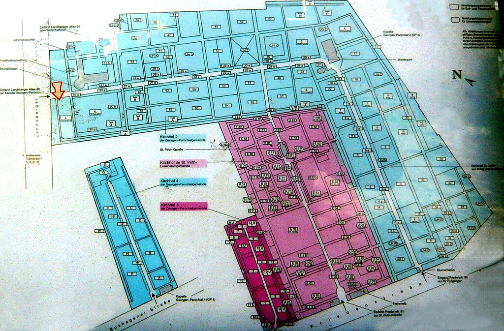
Deutsch: Friedhöfe St. Georgen-, Parochial- und St. Petri-Luisenstadt-Gemeinden |
| Date | |
| Source | Own work |
| Author | 44 penguins (=Angela Monika Arnold, Berlin) |
This file is licensed under the Creative Commons Attribution-Share Alike 2.0 Generic license.
- You are free:
- to share – to copy, distribute and transmit the work
- to remix – to adapt the work
- Under the following conditions:
- attribution – You must give appropriate credit, provide a link to the license, and indicate if changes were made. You may do so in any reasonable manner, but not in any way that suggests the licensor endorses you or your use.
- share alike – If you remix, transform, or build upon the material, you must distribute your contributions under the same or compatible license as the original.
| Object location | | View this and other nearby images on: OpenStreetMap |
|---|
.JPG¶ms=052.520974_N_0013.442674_E_globe:Earth_class:object_type:object_region:DE_dim:1000_&language=en)
File history
Click on a date/time to view the file as it appeared at that time.
| Date/Time | Thumbnail | Dimensions | User | Comment | |
|---|---|---|---|---|---|
| current | 17:56, 24 April 2012 | | 2,103 × 1,382 (824 KB) | 44penguins (talk | contribs) | {{Information |Description= Friedhöfe St.Georgen-, Parochial- und St. Petri-Luisenstadt-Gemeinden |source= own work |Date= 2012-03-23 |Author= 44 penguins (=Angela Monika Arnold, Berlin) |Permission= |Other_versions= }} {{cc-by-sa-2.0}} [[Category:... |
You cannot overwrite this file.
File usage on Commons
The following page uses this file:
File usage on other wikis
The following other wikis use this file:
- Usage on de.wikipedia.org
- Usage on www.wikidata.org
.JPG&oldid=601452073)