File:GNP&BR 1899.png
Jump to navigation
Jump to search

Size of this preview: 385 × 599 pixels. Other resolutions: 154 × 240 pixels | 308 × 480 pixels | 494 × 768 pixels | 658 × 1,024 pixels | 1,800 × 2,800 pixels.
Original file (1,800 × 2,800 pixels, file size: 278 KB, MIME type: image/png)
Captions
Captions
Add a one-line explanation of what this file represents
Summary[edit]
| Description |
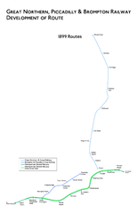
English: Geographic Map of the Great Northern, Piccadilly and Brompton Railway plaaned in 1899. |
| Date | |
| Source | Based on descriptions of route in Badsey-Ellis, Antony (2005). London's Lost Tube Schemes. Capital Transport. ISBN 1-85414-293-3. |
| Author | created by DavidCane |
Part of a set showing the development of the railway's route plans. Also see Image:GNP&BR 1896.png, Image:GNP&BR 1898.png, Image:GNP&BR 1901.png, Image:GNP&BR 1902.png, Image:GNP&BR 1903.png, Image:GNP&BR 1905.png and Image:GNP&BR.png
Licensing[edit]
DavidCane, the copyright holder of this work, hereby publishes it under the following licenses:
This file is licensed under the Creative Commons Attribution-Share Alike 2.5 Generic, 2.0 Generic and 1.0 Generic license.
Attribution: DavidCane
- You are free:
- to share – to copy, distribute and transmit the work
- to remix – to adapt the work
- Under the following conditions:
- attribution – You must give appropriate credit, provide a link to the license, and indicate if changes were made. You may do so in any reasonable manner, but not in any way that suggests the licensor endorses you or your use.
- share alike – If you remix, transform, or build upon the material, you must distribute your contributions under the same or compatible license as the original.

|
Permission is granted to copy, distribute and/or modify this document under the terms of the GNU Free Documentation License, Version 1.2 or any later version published by the Free Software Foundation; with no Invariant Sections, no Front-Cover Texts, and no Back-Cover Texts. A copy of the license is included in the section entitled GNU Free Documentation License. |
| This file is licensed under the Creative Commons Attribution-Share Alike 3.0 Unported license. | ||
| Attribution: DavidCane | ||
| ||
| This licensing tag was added to this file as part of the GFDL licensing update. |
You may select the license of your choice.
based on Image:Piccadilly Line.svg by User:Ed g2s
File history
Click on a date/time to view the file as it appeared at that time.
| Date/Time | Thumbnail | Dimensions | User | Comment | |
|---|---|---|---|---|---|
| current | 22:13, 18 October 2008 | | 1,800 × 2,800 (278 KB) | DavidCane (talk | contribs) | == Description == {{Information |Description={{en|1=Geographic Map of the Great Northern, Piccadilly and Brompton Railway plaaned in 1899.}} |Author=created by DavidCane |Date=2008-10-04 |Source=Self-made |other_versions= }} {{Imag |
You cannot overwrite this file.
File usage on Commons
There are no pages that use this file.
File usage on other wikis
The following other wikis use this file:
- Usage on en.wikipedia.org