File:Gabon Regions map.png
Jump to navigation
Jump to search

Size of this preview: 574 × 599 pixels. Other resolutions: 230 × 240 pixels | 460 × 480 pixels | 736 × 768 pixels | 981 × 1,024 pixels | 2,498 × 2,608 pixels.
Original file (2,498 × 2,608 pixels, file size: 1.08 MB, MIME type: image/png)
Captions
Captions
Add a one-line explanation of what this file represents
Summary[edit]
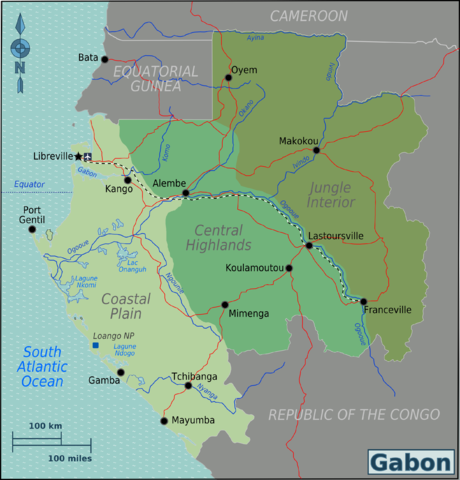
| Description | Map of Gabon for use on Wikivoyage, English version |
| Date | |
| Source | Own work based on Perry-Castañeda Library Map Collection Gabon Maps |
| Author | Burmesedays |
| Other versions | SVG source |
Licensing[edit]
This file is licensed under the Creative Commons Attribution-Share Alike 3.0 Unported license.
- You are free:
- to share – to copy, distribute and transmit the work
- to remix – to adapt the work
- Under the following conditions:
- attribution – You must give appropriate credit, provide a link to the license, and indicate if changes were made. You may do so in any reasonable manner, but not in any way that suggests the licensor endorses you or your use.
- share alike – If you remix, transform, or build upon the material, you must distribute your contributions under the same or compatible license as the original.
Original upload log[edit]
| This file was imported from Wikivoyage WTS. |
The original description page was here. All following user names refer to wts.wikivoyage-old.
- 2010-01-24 14:56 (WT-shared) Burmesedays[dead link] 2498×2608 (1105216 bytes) {{Imagecredit|credit=[[user:burmesedays]], [http://www.lib.utexas.edu/maps/gabon.html Perry-Castañeda Library Map Collection Gabon Maps]|ca (Import from wikitravel.org/shared)
- 2010-01-25 03:34 (WT-shared) Burmesedays[dead link] 2498×2608 (1140887 bytes) adjusted font sizes, dunno what I was thinking (Import from wikitravel.org/shared)
- 2010-01-26 10:13 (WT-shared) Burmesedays[dead link] 2498×2608 (1144283 bytes) minor fixes, equator line (Import from wikitravel.org/shared)
- 2010-04-25 08:53 (WT-shared) Burmesedays[dead link] 2498×2608 (1132013 bytes) (Import from wikitravel.org/shared)
File history
Click on a date/time to view the file as it appeared at that time.
| Date/Time | Thumbnail | Dimensions | User | Comment | |
|---|---|---|---|---|---|
| current | 07:43, 23 November 2012 | | 2,498 × 2,608 (1.08 MB) | OgreBot (talk | contribs) | (BOT): Reverting to most recent version before archival |
| 07:43, 23 November 2012 |  | 2,498 × 2,608 (1.09 MB) | OgreBot (talk | contribs) | (BOT): Uploading old version of file from wts.wikivoyage-old; originally uploaded on 2010-01-26 10:13:54 by (WT-shared) Burmesedays | |
| 07:43, 23 November 2012 |  | 2,498 × 2,608 (1.09 MB) | OgreBot (talk | contribs) | (BOT): Uploading old version of file from wts.wikivoyage-old; originally uploaded on 2010-01-25 03:34:43 by (WT-shared) Burmesedays | |
| 07:43, 23 November 2012 |  | 2,498 × 2,608 (1.05 MB) | OgreBot (talk | contribs) | (BOT): Uploading old version of file from wts.wikivoyage-old; originally uploaded on 2010-01-24 14:56:49 by (WT-shared) Burmesedays | |
| 23:47, 17 November 2012 |  | 2,498 × 2,608 (1.08 MB) | MGA73bot2 (talk | contribs) | {{BotMoveToCommons|wts.oldwikivoyage|year={{subst:CURRENTYEAR}}|month={{subst:CURRENTMONTHNAME}}|day={{subst:CURRENTDAY}}}} == {{int:filedesc}} == {{Information |description=Map of Gabon. Map of Gabon, Gabon * Map of: Gabon¤ |date=January 24th 2010 |s... |
You cannot overwrite this file.
File usage on Commons
There are no pages that use this file.
File usage on other wikis
The following other wikis use this file:
- Usage on el.wikivoyage.org
- Usage on en.wikivoyage.org
- Usage on fr.wikivoyage.org
- Usage on he.wikivoyage.org
- Usage on incubator.wikimedia.org
- Usage on it.wikivoyage.org
- Usage on ja.wikivoyage.org
- Usage on pt.wikipedia.org
- Usage on vi.wikivoyage.org
- Usage on zh.wikivoyage.org