File:Gardenville (Village); New Ebenezer (Village) NYPL1584551.tiff
Jump to navigation
Jump to search

Size of this JPG preview of this TIF file: 467 × 600 pixels. Other resolutions: 187 × 240 pixels | 374 × 480 pixels | 598 × 768 pixels | 797 × 1,024 pixels | 1,594 × 2,048 pixels | 5,428 × 6,972 pixels.
Original file (5,428 × 6,972 pixels, file size: 108.27 MB, MIME type: image/tiff)
Captions
Captions
Add a one-line explanation of what this file represents
Summary[edit]
| Description | Gardenville [Village]; New Ebenezer [Village]; Atlases of the United States / New York / Illustrated historical atlas of Erie Co., New York from actual surveys and records. | |||||||||||||||||||||||
| Catalogue call number | Map Div. 76-255 | |||||||||||||||||||||||
| Item/Page/Plate | 98 | |||||||||||||||||||||||
| Date | ||||||||||||||||||||||||
| Source |
http://digitalgallery.nypl.org/nypldigital/dgkeysearchdetail.cfm?imageID=1584551
|
|||||||||||||||||||||||
| Author | F.W. Beers and Co. -- Cartographer | |||||||||||||||||||||||
| Permission (Reusing this file) |
From The Lionel Pincus and Princess Firyal Map Division. http://maps.nypl.org
|
|||||||||||||||||||||||
| Location | Stephen A. Schwarzman Building / The Lionel Pincus and Princess Firyal Map Division | |||||||||||||||||||||||
| Digital item published | 7-23-2007; updated 3-25-2011 | |||||||||||||||||||||||
| Digital ID | 1584551 | |||||||||||||||||||||||

The making of this file was supported by Wikimedia UK.
To see other files made with the support of Wikimedia UK, please see the category Supported by Wikimedia UK.
|
File history
Click on a date/time to view the file as it appeared at that time.
| Date/Time | Thumbnail | Dimensions | User | Comment | |
|---|---|---|---|---|---|
| current | 13:46, 28 April 2014 | 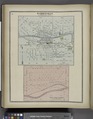 | 5,428 × 6,972 (108.27 MB) | Fæ (talk | contribs) | GWToolset:: Creating mediafile for Fæ. Tranche 3 5495-7474 (2) |
You cannot overwrite this file.
File usage on Commons
There are no pages that use this file.