File:Gazastreifen Raketenreichweiten.png
Jump to navigation
Jump to search

Size of this preview: 356 × 599 pixels. Other resolutions: 142 × 240 pixels | 285 × 480 pixels | 456 × 768 pixels | 1,200 × 2,019 pixels.
Original file (1,200 × 2,019 pixels, file size: 546 KB, MIME type: image/png)
Captions
Captions
Add a one-line explanation of what this file represents

|
This military map image could be re-created using vector graphics as an SVG file. This has several advantages; see Commons:Media for cleanup for more information. If an SVG form of this image is available, please upload it and afterwards replace this template with
{{vector version available|new image name}}.
It is recommended to name the SVG file “Gazastreifen Raketenreichweiten.svg”—then the template Vector version available (or Vva) does not need the new image name parameter. |
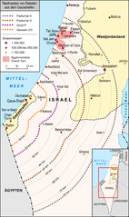
| Description | Maßstäbliche Karte der möglichen Reichweiten von Raketen, die aus dem Gazastreifen auf israelisches Gebiet abgefeuert werden. |
| Date | |
| Source |
own work, used:
|
| Author | Lencer |
| Other versions |
|


This file is licensed under the Creative Commons Attribution-Share Alike 3.0 Unported license.
- You are free:
- to share – to copy, distribute and transmit the work
- to remix – to adapt the work
- Under the following conditions:
- attribution – You must give appropriate credit, provide a link to the license, and indicate if changes were made. You may do so in any reasonable manner, but not in any way that suggests the licensor endorses you or your use.
- share alike – If you remix, transform, or build upon the material, you must distribute your contributions under the same or compatible license as the original.

|
This map has been made or improved in the German Kartenwerkstatt (Map Lab). You can propose maps to improve as well.
|
File history
Click on a date/time to view the file as it appeared at that time.
| Date/Time | Thumbnail | Dimensions | User | Comment | |
|---|---|---|---|---|---|
| current | 19:29, 9 March 2014 | | 1,200 × 2,019 (546 KB) | Kopiersperre (talk | contribs) | optipng |
| 06:41, 5 February 2013 |  | 1,200 × 2,019 (665 KB) | Lencer (talk | contribs) | + Fadschr-5 Reichweite, Karte vergrößert, mehr Städte, Legende angepasst | |
| 19:50, 9 January 2009 |  | 867 × 1,200 (326 KB) | Lencer (talk | contribs) | {{Information |Description= |Source= |Date= |Author= |Permission= |other_versions= }} | |
| 19:15, 9 January 2009 |  | 867 × 1,200 (312 KB) | Lencer (talk | contribs) | {{Information| |Description=Maßstäbliche Karte der möglichen Reichweiten von Raketen, die aus dem Gazastreifen auf israelisches Gebiet abgefeuert werden. |Source=own work, used: * Wikipedia-Artikel zu den Raketentypen: [[:de:Qassam | |
| 18:53, 9 January 2009 |  | 867 × 1,200 (309 KB) | Lencer (talk | contribs) | {{Information| |Description=Maßstäbliche Karte der möglichen Reichweiten von Raketen, die aus dem Gazastreifen auf israelisches Gebiet abgefeuert werden. |Source=own work, used: * Wikipedia-Artikel zu den Raketentypen: [[:de:Qassam |
You cannot overwrite this file.
File usage on Commons
The following 3 pages use this file:
File usage on other wikis
The following other wikis use this file:
- Usage on de.wikipedia.org
- Qassam-Rakete
- Qassam-Brigaden
- Fadschr-5 (Artillerierakete)
- Fadschr-3 (Artillerierakete)
- Benutzer:Lencer
- Benutzer Diskussion:Lencer/Archiv
- Operation Gegossenes Blei
- Wikipedia:Kartenwerkstatt/Archiv/2009-01
- Iron Dome
- Benutzer:KaterBegemot/Kartografen
- Operation Wolkensäule
- Wikipedia:Kartenwerkstatt/Archiv/2013-02
- Wikipedia:Kartenwerkstatt/Karte des Tages/Galerie
- Gaza Envelope
- Usage on de.wikinews.org
- Usage on es.wikipedia.org
- Usage on hr.wikipedia.org
- Usage on pl.wikipedia.org
- Usage on sh.wikipedia.org