File:Generalized Geological Map of Godavari Drainage Basin.jpg
Jump to navigation
Jump to search
Size of this preview: 800 × 566 pixels. Other resolutions: 320 × 226 pixels | 640 × 453 pixels | 1,024 × 724 pixels | 1,280 × 905 pixels | 2,560 × 1,810 pixels | 3,507 × 2,480 pixels.
Original file (3,507 × 2,480 pixels, file size: 513 KB, MIME type: image/jpeg)
Captions
Captions
Add a one-line explanation of what this file represents
Summary[edit]
| Description |
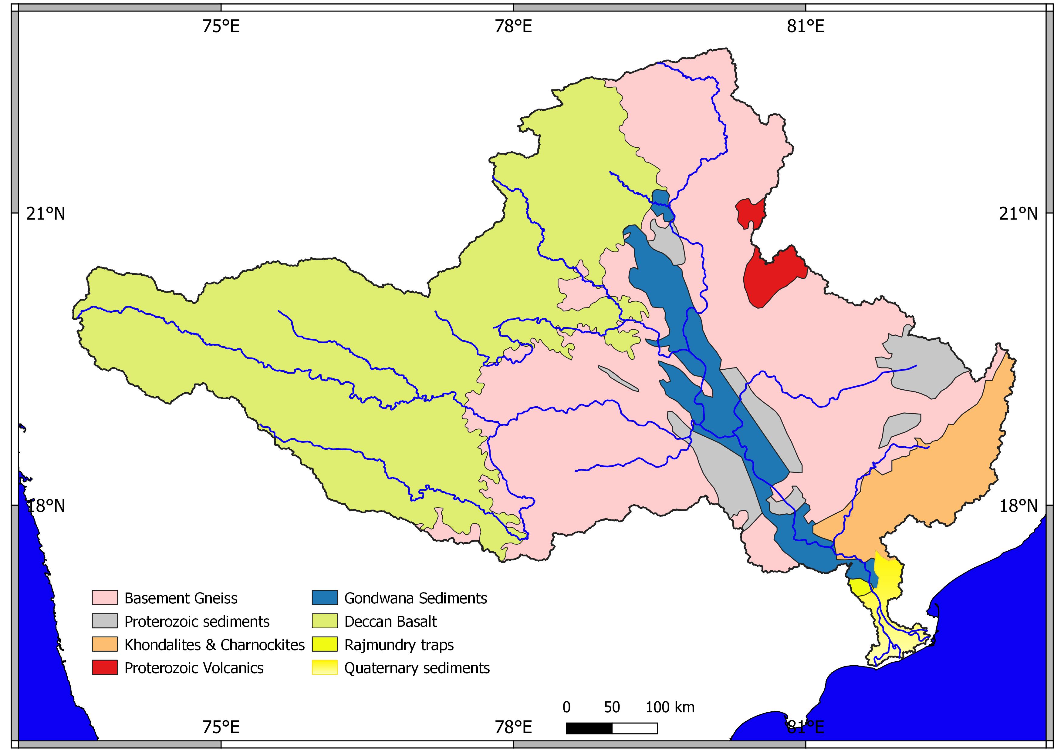
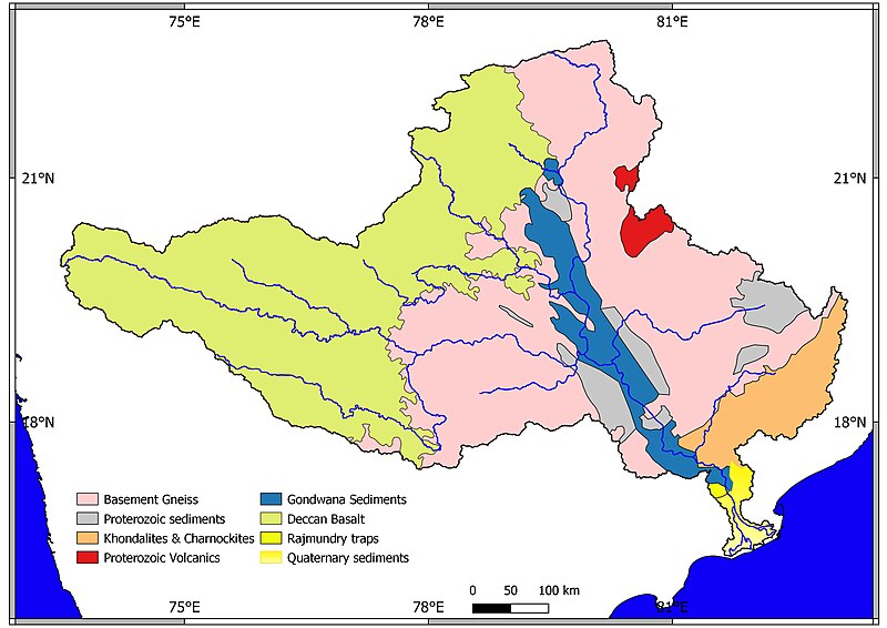
English: Map Prepared after Geological map of India, by Geological Survey of India with scale 1:2,50,000 |
| Date | |
| Source | Own work |
| Author | Kulyogesh19 |
Licensing[edit]
I, the copyright holder of this work, hereby publish it under the following license:
This file is licensed under the Creative Commons Attribution-Share Alike 4.0 International license.
- You are free:
- to share – to copy, distribute and transmit the work
- to remix – to adapt the work
- Under the following conditions:
- attribution – You must give appropriate credit, provide a link to the license, and indicate if changes were made. You may do so in any reasonable manner, but not in any way that suggests the licensor endorses you or your use.
- share alike – If you remix, transform, or build upon the material, you must distribute your contributions under the same or compatible license as the original.
File history
Click on a date/time to view the file as it appeared at that time.
| Date/Time | Thumbnail | Dimensions | User | Comment | |
|---|---|---|---|---|---|
| current | 08:52, 9 June 2023 | | 3,507 × 2,480 (513 KB) | Kulyogesh19 (talk | contribs) | Updated |
| 13:03, 11 September 2017 |  | 3,787 × 2,147 (382 KB) | Kulyogesh19 (talk | contribs) | Cross-wiki upload from en.wikipedia.org |
You cannot overwrite this file.
File usage on Commons
There are no pages that use this file.
File usage on other wikis
The following other wikis use this file:
- Usage on en.wikipedia.org
- Godavari River
- Gadchiroli district
- Deccan Plateau
- Eastern Ghats
- Vidarbha
- East Godavari district
- Yavatmal district
- Bastar district
- Buldhana district
- Coastal Andhra
- Himroo
- West Godavari district
- Parbhani district
- Chandrapur district
- Koraput district
- Bhandara district
- Beed district
- Gondia district
- Hingoli district
- Wainganga River
- Amravati district
- Wardha River
- Indravati River
- Kalahandi district
- Aurangabad district, Maharashtra
- Betul district
- Washim district
- Dowleswaram Barrage
- Godavari River Basin Irrigation Projects
- Balimela Reservoir
- Nizam Sagar Dam
- Sriram Sagar Project
- Balaghat district
- Chhindwara district
- Seoni district
- Wardha district
- Nashik district
- Nanded district
- Nagpur district
- Khammam district
- Karimnagar district
- Medak district
- Nizamabad district
- Hanamkonda district
- Bidar district
- Konaseema
- Ahmednagar district
- Godavari Bridge
- Manjira River
- Malkangiri district
View more global usage of this file.