File:Gibraltar map-en-edit2.svg
Jump to navigation
Jump to search

Size of this PNG preview of this SVG file: 385 × 600 pixels. Other resolutions: 154 × 240 pixels | 308 × 480 pixels | 493 × 768 pixels | 657 × 1,024 pixels | 1,314 × 2,048 pixels | 1,000 × 1,558 pixels.
Original file (SVG file, nominally 1,000 × 1,558 pixels, file size: 1.46 MB)
Captions
Captions
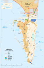
Map of Gibraltar
Summary[edit]
|
This W3C-unspecified vector image was created with Inkscape .
| Camera location | | View this and other nearby images on: OpenStreetMap |
|---|
| Description |
English: Map in English of Gibraltar
Français : Carte en anglais de Gibraltar |
| Date | |
| Source |
English: adapted from: Image:Gibraltar map-en.svg
Français : Création personnelle ;
|
| Author | Original by Eric Gaba (Sting), label/legend edits by Jeff Dahl |
| Permission (Reusing this file) |
Attribution and Share-Alike required |
| Other versions |
|


|
This SVG file contains embedded text that can be translated into your language, using any capable SVG editor, text editor or the SVG Translate tool. For more information see: About translating SVG files. |
Licensing[edit]
I, the copyright holder of this work, hereby publish it under the following licenses:

|
Permission is granted to copy, distribute and/or modify this document under the terms of the GNU Free Documentation License, Version 1.2 or any later version published by the Free Software Foundation; with no Invariant Sections, no Front-Cover Texts, and no Back-Cover Texts. A copy of the license is included in the section entitled GNU Free Documentation License. |
This file is licensed under the Creative Commons Attribution-Share Alike 4.0 International, 3.0 Unported, 2.5 Generic, 2.0 Generic and 1.0 Generic license.
- You are free:
- to share – to copy, distribute and transmit the work
- to remix – to adapt the work
- Under the following conditions:
- attribution – You must give appropriate credit, provide a link to the license, and indicate if changes were made. You may do so in any reasonable manner, but not in any way that suggests the licensor endorses you or your use.
- share alike – If you remix, transform, or build upon the material, you must distribute your contributions under the same or compatible license as the original.
You may select the license of your choice.
File history
Click on a date/time to view the file as it appeared at that time.
| Date/Time | Thumbnail | Dimensions | User | Comment | |
|---|---|---|---|---|---|
| current | 16:36, 5 April 2017 | | 1,000 × 1,558 (1.46 MB) | RaviC (talk | contribs) | + University, Ferry terminal (& Route), Cathedral |
| 18:52, 11 December 2007 |  | 1,000 × 1,558 (1.79 MB) | Jeff Dahl (talk | contribs) | resized 1200 down to 1000px wide, minor label fixes | |
| 17:08, 10 December 2007 |  | 1,200 × 1,870 (1.78 MB) | Jeff Dahl (talk | contribs) | {{inkscape}} {{Location|36|08|00|N|5|21|00|W|type:city_scale:50000}} {{Information |Description=Map in English of Gibraltar |Source=adapted from: Image:Gibraltar map-en.svg <br/>Map created using screenshots of [[:en:Google Ea |
You cannot overwrite this file.
File usage on Commons
The following 37 pages use this file:
- User:Hide on Rosé/Commons:Translation possible/Tìm hiểu thêm
- Commons:Translation possible/Ajuda
- Commons:Translation possible/Aprenda mais
- Commons:Translation possible/Aprende más
- Commons:Translation possible/Dowiedz się więcej
- Commons:Translation possible/Learn more
- Commons:Translation possible/Learn more/tr
- Commons:Translation possible/Mehr erfahren
- Commons:Translation possible/Para saber máis
- Commons:Translation possible/Per saperne di più
- Commons:Translation possible/Saznajte više
- Commons:Translation possible/Дознајте повеќе
- Commons:Translation possible/اطلاعات بیشتر
- Commons:Translation possible/了解更多
- Commons:Translation possible/詳情
- Commons:Translation possible/詳細
- Commons:Translation possible/더 보기
- File:Gibraltar map-HE.svg
- File:Gibraltar map-de.svg
- File:Gibraltar map-en.svg
- File:Gibraltar map-es.svg
- File:Gibraltar map-fr.svg
- File:Gibraltar map-hu.svg
- File:Gibraltar map-it.svg
- File:Gibraltar map-mk.svg
- File:Gibraltar map-ms.svg
- File:Gibraltar map-pl.svg
- File:Gibraltar map-uk.svg
- File:Gibraltar map-ur.svg
- File:Gibraltar map (claimed isthmus)-es.svg
- File:Gibraltar map (non Utrech territories)-es.svg
- File:Gibraltar map (reclaimed land)-es.svg
- File:Xibraltarplano-en.jpg
- File:Xibraltarplano-es.jpg
- File:Xibraltarplano-es cut.jpg
- File:Xibraltarplano-gl.jpg
- Template:Other versions/Gibraltar map
-es.svg)
-es.svg)
-es.svg)
File usage on other wikis
The following other wikis use this file:
- Usage on af.wikipedia.org
- Usage on ar.wikipedia.org
- Usage on av.wikipedia.org
- Usage on azb.wikipedia.org
- Usage on bg.wikipedia.org
- Usage on bn.wikipedia.org
- Usage on bs.wikipedia.org
- Usage on ceb.wikipedia.org
- Plantilya:Location map Gibraltar
- Signal Hill
- White Rock
- Sandy Bay
- Roca Blanca
- Ailsa Craig
- Passage Point
- El Peñón
- The Rock
- Middle Hill
- Gibraltar (pagklaro)
- Rock of Gibraltar
- Deadmans Beach
- Eastern Beach
- Western Beach
- Punta Pasaje
- Punta Europa
- La Roca
- Governor’s Beach
- Camp Bay
- Europa Point
- Gibraltar Bay
- Cerro de Enmedio
- Blackstrap Bay
- Caledonian Canal
- Great Europa Point
- Gibilterra
- White Rock (bato sa Gyibraltar)
- Western Beach (lapyahan sa Gyibraltar)
- Signal Hill (bungtod sa Gyibraltar)
- Sandy Bay North
- Sandy Bay (luuk)
- Saint Michael's Cave
- Saint Abb's Head
- North Gorge
- Middle Hill (bungtod sa Gyibraltar)
- Mediterranean Steps
- Martin's Cave
- Europa Point (punta sa Gyibraltar)
- The Lido
- Levant Cave
- H.M.S. Rooke
View more global usage of this file.