File:Greenutrivermap.png
Jump to navigation
Jump to search
No higher resolution available.
Greenutrivermap.png (500 × 500 pixels, file size: 409 KB, MIME type: image/png)
Captions
Captions
Add a one-line explanation of what this file represents
Summary[edit]
| Description |
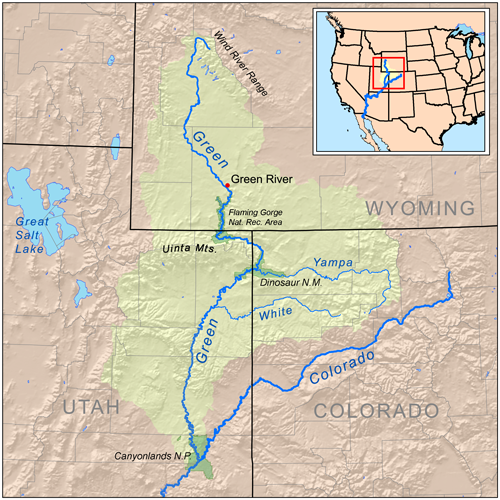
Map of the watershed-basin of the Green River and tributary Yampa River; and the upper Colorado River.
|
| Date | |
| Source | Self-made, based on USGS data. |
| Author | Kmusser |
Licensing[edit]
I, the copyright holder of this work, hereby publish it under the following license:
This file is licensed under the Creative Commons Attribution-Share Alike 3.0 Unported license.
- You are free:
- to share – to copy, distribute and transmit the work
- to remix – to adapt the work
- Under the following conditions:
- attribution – You must give appropriate credit, provide a link to the license, and indicate if changes were made. You may do so in any reasonable manner, but not in any way that suggests the licensor endorses you or your use.
- share alike – If you remix, transform, or build upon the material, you must distribute your contributions under the same or compatible license as the original.
File history
Click on a date/time to view the file as it appeared at that time.
| Date/Time | Thumbnail | Dimensions | User | Comment | |
|---|---|---|---|---|---|
| current | 17:21, 15 July 2008 | | 500 × 500 (409 KB) | Kmusser (talk | contribs) | == Summary == {{Information |Description=Map of the Green River watershed. |Source=Self-made, based on USGS data. |Author=Kmusser |Date=July 15, 2008 |Permission= |other_versions= }} [[Category:Map |
You cannot overwrite this file.
File usage on Commons
The following 2 pages use this file:
File usage on other wikis
The following other wikis use this file:
- Usage on arz.wikipedia.org
- Usage on be.wikipedia.org
- Usage on bg.wikipedia.org
- Usage on chy.wikipedia.org
- Usage on cs.wikipedia.org
- Usage on da.wikipedia.org
- Usage on de.wikipedia.org
- Usage on en.wikipedia.org
- Usage on es.wikipedia.org
- Usage on fr.wikipedia.org
- Usage on he.wikipedia.org
- Usage on hr.wikipedia.org
- Usage on hy.wikipedia.org
- Usage on it.wikipedia.org
- Usage on ja.wikipedia.org
- Usage on lt.wikipedia.org
- Usage on ml.wikipedia.org
- Usage on nl.wikipedia.org
- Usage on no.wikipedia.org
- Usage on pl.wikipedia.org
- Usage on pt.wikipedia.org
- Usage on ru.wikipedia.org
- Usage on sh.wikipedia.org
- Usage on simple.wikipedia.org
- Usage on sr.wikipedia.org
- Usage on ta.wikipedia.org
- Usage on tr.wikipedia.org
- Usage on www.wikidata.org
- Usage on xmf.wikipedia.org
- Usage on zh.wikipedia.org
Categories:
- Maps of the Green River (Colorado River)
- Maps of rivers in Colorado
- Maps of rivers in Utah
- Maps of rivers in Wyoming
- Colorado River Basin
- Tributaries of the Colorado River in Colorado
- Tributaries of the Colorado River in Utah
- Tributaries of the Colorado River in Wyoming
- Uinta Basin
- Maps of the Colorado River
- Yampa River
- White River (Green River)
- Flaming Gorge National Recreation Area
- Maps of Dinosaur National Monument
- Maps of Canyonlands National Park