File:Gropavallar registrerade i Sverige 2015 (med text).jpg
Jump to navigation
Jump to search
Size of this preview: 543 × 599 pixels. Other resolutions: 217 × 240 pixels | 435 × 480 pixels | 696 × 768 pixels | 1,274 × 1,406 pixels.
Original file (1,274 × 1,406 pixels, file size: 534 KB, MIME type: image/jpeg)
Captions
Captions
Add a one-line explanation of what this file represents
Summary[edit]
.jpg&action=edit§ion=1)
| Description |
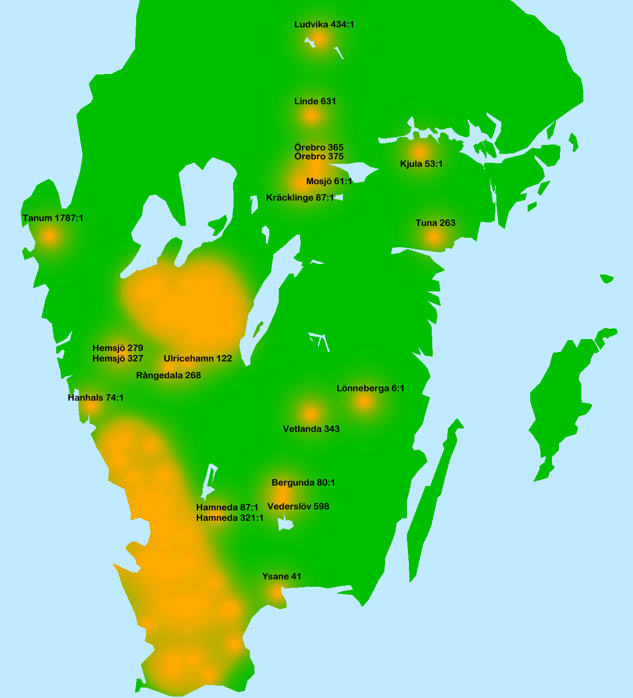
Svenska: Utbredning av gropavallar i Sverige. Gropavallen är en äldre typ av hägnad som främst förekommer i Västergötland, Halland och Skåne i Sverige. En gropavall består av ett dike och en uppkastad jordvall, som kan vara stensatt eller stenblandad. Gropavallens syfte var att förhindra betesdjur att komma in på brukad mark. Kartan visar utbredningen av registrerade gropavallar i Sverige (alla benämnda "gropavall" eller "gropvall", samt några hägnadsvallar med dike). Utbredningen av i FMIS Fornsök registrerade gropavallar i södra Sverige visas här med orange. Sverige är grönt, medan hav och sjö är ljusblå. Uppgifterna tagna ur FMIS Fornsök och gäller registreringsläget där 2015-06-19.
För de gropavallar som ligger utanför huvudområdena i Skåne, Halland och centrala Västergötland har RAÄ-nummer angetts på kartan. Dessa är: Blekinge: RAÄ-nr Ysane 41. Småland: RAÄ-nr Bergunda 80:1, RAÄ-nr Hamneda 87:1, RAÄ-nr Hamneda 321:1, RAÄ-nr Lönneberga 6:1, RAÄ-nr Vederslöv 598, RAÄ-nr Vetlanda 343 Norra Halland: RAÄ-nr Hanhals 74:1. Bohuslän: RAÄ-nr Tanum 1787:1. Södra Västergötland: RAÄ-nr Hemsjö 279, RAÄ-nr Hemsjö 327, RAÄ-nr Rångedala 268, RAÄ-nr Ulricehamn 122. Närke: RAÄ-nr Kräcklinge 87:1, RAÄ-nr Mosjö 61:1, RAÄ-nr Örebro 365, RAÄ-nr Örebro 375. Södermanland: RAÄ-nr Kjula 53:1, RAÄ-nr Tuna 263. Västmanland: RAÄ-nr Linde 631. Dalarna: RAÄ-nr Ludvika 434:1. English: Distributional map of ditched fences in Sweden. The ditched fence (Sw. "gropavall") is an old type of agricultural fence typical for some provinces of Sweden; Västergötland, Halland, and Skåne. The ditched fence consist of a ditch and an earth wall, sometimes reinforced by stones. The purpuse of the ditched fence was to prevent cattle to walk into tilled land. The map shows the distribution of ditched fences registred in the FMIS Fornsök database 19 June 2015. Orange shows the distribution. Sweden is green, and sea and lakes are light blue. For the ditched fences outside the main distribution areas the RAÄ numbers are given. |
| Date | |
| Source | Own work |
| Author | Gunnar Creutz |
| Other versions |
.jpg) |
Licensing[edit]
.jpg&action=edit§ion=2)
I, the copyright holder of this work, hereby publish it under the following license:
This file is licensed under the Creative Commons Attribution-Share Alike 4.0 International license.
- You are free:
- to share – to copy, distribute and transmit the work
- to remix – to adapt the work
- Under the following conditions:
- attribution – You must give appropriate credit, provide a link to the license, and indicate if changes were made. You may do so in any reasonable manner, but not in any way that suggests the licensor endorses you or your use.
- share alike – If you remix, transform, or build upon the material, you must distribute your contributions under the same or compatible license as the original.
File history
Click on a date/time to view the file as it appeared at that time.
| Date/Time | Thumbnail | Dimensions | User | Comment | |
|---|---|---|---|---|---|
| current | 07:18, 23 June 2015 | | 1,274 × 1,406 (534 KB) | Achird (talk | contribs) | Reverted to version as of 07:16, 23 June 2015 |
| 07:17, 23 June 2015 |  | 1,274 × 1,406 (534 KB) | Achird (talk | contribs) | Trying the correction again | |
| 07:16, 23 June 2015 |  | 1,274 × 1,406 (534 KB) | Achird (talk | contribs) | More correction of numbers | |
| 07:09, 23 June 2015 |  | 1,274 × 1,406 (524 KB) | Achird (talk | contribs) | A number corrected. | |
| 14:04, 22 June 2015 |  | 1,274 × 1,406 (513 KB) | Achird (talk | contribs) | User created page with UploadWizard |
You cannot overwrite this file.
File usage on Commons
The following 3 pages use this file:
.jpg&oldid=819252663)