File:Guiana and Caribana WDL11336.png
Jump to navigation
Jump to search

Size of this preview: 798 × 600 pixels. Other resolutions: 320 × 240 pixels | 639 × 480 pixels | 1,022 × 768 pixels | 1,280 × 962 pixels | 1,363 × 1,024 pixels.
Original file (1,363 × 1,024 pixels, file size: 2.79 MB, MIME type: image/png)
Captions
Captions
Add a one-line explanation of what this file represents
Summary[edit]
| Author |
Русский: Сансон, Николас (1600-1667)
Français : Sanson, Nicolas (1600-1667)
English: Sanson, Nicolas (1600-1667)
中文:桑松, 尼古拉斯 (1600-1667)
Português: Sanson, Nicolas (1600-1667)
العربية: سانسون، نيكولاس (1600-1667)
Español: Sanson, Nicolas (1600-1667) |
| Title |
Русский: Гвиана и Карибана
Français : Guyana et Caribana
English: Guiana and Caribana
中文:圭亚那和卡瑞巴纳
Português: Guiana e Caribana
العربية: غويانا وكاريبانا
Español: Guayana y Caribaná |
| Description |
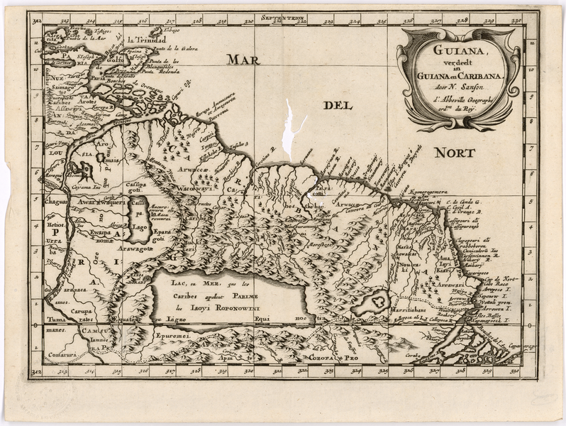
Русский: Эта карта части северного побережья Южной Америки является голландским изданием карты, изначально составленной около 1650 года Николасом Сансоном (1600–1667 гг.), географом при дворе королей Людовика XIII и Людовика XIV, которого считают отцом французской картографии. В начале XVIII века вышло множество изданий, являющихся копией карты Сансона. На карте изображен регион от острова Тринидад и устья реки Ориноко на западе до устья реки Амазонки на юго-востоке. Сансон подразделяет эту область на Новую Андалусию, Гвиану и Карибану и перечисляет населяющие регион коренные племена. Интерес европейцев к этому региону подстегнула публикация очерка сэра Уолтера Рейли "Открытие большой, богатой и красивой империи Гвиана", появившегося в 1596 году. В 1595 году Рейли совершил экспедицию вверх по реке Ориноко в поисках легендарного королевства Эльдорадо. Считалось, что оно располагается на берегах большого водоема, известного как озеро Парима. На этой карте показано озеро, обязанное своим названием племени карибов. Тот факт, что мистического озера не существует, был достоверно доказан только в XIX веке.
Нидерланды - Колонии; Испания–Колонии Français : Cette carte d'une partie de la côte septentrionale de l'Amérique du Sud est une version néerlandaise d'une carte produite initialement vers 1650 par Nicolas Sanson (1600-1667), géographe royal des rois Louis XIII et Louis XIV, communément surnommé le père de la cartographie française. De nombreuses éditions copiées à partir de l'exemplaire de Sanson ont été imprimées au début du XVIIIe siècle. La carte couvre la région de l'île de Trinidad et l'embouchure du fleuve Orénoque, à l'ouest, jusqu'à l'embouchure du fleuve Amazone, au sud-est. Sanson divise cette zone en trois parties : Nouvelle Andalousie, Guyana et Caribana. Il indique également les noms des peuples autochtones vivant dans la région. L'intérêt des Européens pour cette région fut suscité par la publication de l'ouvrage de Sir Walter Raleigh Découverte du grand, riche et bel empire de la Guyana en 1596. Raleigh avait monté une expédition en 1595 pour remonter l'Orénoque à la recherche du légendaire royaume de l'Eldorado. Ce royaume était censé se situer sur les rives d'une vaste étendue d'eau appelée le lac Parime. Cette carte montre le lac et attribue son nom au peuple Caraïbe. La non-existence de ce lac mythique fut définitivement prouvée au XIXe siècle.
Pays-Bas--Colonies; Espagne--Colonies English: This map of part of the northern coast of South America is a Dutch version of a map originally produced around 1650 by Nicolas Sanson (1600–1667), royal geographer to Kings Louis XIII and XIV, and commonly known as the father of French cartography. Numerous editions copied from Sanson were printed in the early 18th century. The map covers the region from the island of Trinidad and the mouth of the Orinoco River in the west to the mouth of the Amazon River in the southeast. Sanson divides this area into New Andalusia, Guiana, and Caribana and gives the names of the indigenous peoples inhabiting the region. European interest in this region was spurred by the publication, in 1596, of Sir Walter Raleigh’s The Discovery of the Large, Rich and Beautiful Empire of Guiana. Raleigh had made an expedition in 1595 up the Orinoco River in search of the legendary kingdom of El Dorado. The kingdom was believed to be located on the shores of a large body of water, known as Lake Parime. This map shows the lake, and attributes its name to the Carib people. The nonexistence of the mythical lake was not definitively proven until the 19th century.
Netherlands--Colonies; Spain--Colonies 中文:这张地图显示了南美洲北部海岸的一部分,是一张荷兰文地图,最早由尼古拉斯·桑松(Nicolas Sanson,1600-1667 年)在 1650 年左右制作完成,桑松是法王路易十三 (Louis XIII) 和路易十四 (Louis XIV) 的皇家地理学家,被称为法国制图之父。18 世纪初,有众多复制桑松版本的地图出版。这张地图涵盖了从特立尼达岛和奥里诺科河西部河口到亚马逊河东南部河口的地区。桑松将此区域划分成新安达卢西亚、圭亚那和卡瑞巴纳三部分,并标出了居住在该地区的土著部族名称。1596 年,沃尔特·罗利爵士 (Sir Walter Raleigh) 出版了《发现广阔、富饶和美丽的帝国圭亚那》,激发了欧洲人对这一地区的兴趣。1595 年,罗利对奥里诺科河上游进行了一次探险,寻找传说中的埃尔多拉多王国。据说这个王国位于一个称为帕里梅湖的大湖旁边。这张地图上显示了这个湖泊,并指其名称来自加勒比人。直到 19 世纪,这个神秘湖泊才被明确证实并不存在。
荷兰-殖民地; 西班牙-殖民地 Português: Este mapa de parte da costa norte da América do Sul é uma versão holandesa de um mapa originalmente produzido por volta de 1650 por Nicolas Sanson (1600 a 1667), geógrafo real dos reis Luís XIII e Luís XIV e comumente conhecido como o pai da cartografia francesa. Várias edições copiadas de Sanson foram impressas no início do século XVIII. O mapa cobre a região da ilha de Trinidad e a foz do rio Orinoco no oeste da foz do rio Amazonas no sudeste. Sanson divide essa área em Nova Andaluzia, Guiana e Caribana, e dá nomes aos povos indígenas que habitam a região. O interesse europeu nesta região foi estimulado pela publicação, em 1596, do A descoberta do grande, rico e belo império da Guiana de Sir Walter Raleigh. Raleigh fez uma expedição em 1595 subindo o rio Orinoco em busca do lendário reino de El Dorado. Acreditava-se que o reino estava localizado nas margens de um grande corpo d'água, conhecido como Lago Parime. Este mapa mostra o lago e atribui seu nome aos povos do Caribe. A não existência do lago místico não foi definitivamente provada até o século XIX.
Países Baixos - Colônias; Espanha - Colônias العربية: تُعد هذه الخريطة لجزء من الساحل الشمالي لأمريكا الجنوبية نسخة هولندية لخريطة وضعت في الأصل قرابة عام 1650 بواسطة نيكولا سانسون (1600-1667)، وهو جغرافي ملكي عمِل لدى الملِكَيْن لويس الثالث عشر والرابع عشر، ويشتهر بأنه أبو فن رسم الخرائط الفرنسي. طُبعت العديد من الطبعات المنسوخة من سانسون في أوائل القرن الثامن عشر. تشمل الخريطة المنطقة من جزيرة ترينيداد وفم نهر أورينوكو في الغرب إلى فم نهر الأمازون في الجنوب الشرقي. يقسم سانسون هذه المنطقة إلى الأندلس الجديدة وغويانا وكاريبانا ويُعطي أسماء الشعوب الأصلية بالمنطقة. حفَّز نشْر كتاب اكتشاف إمبراطورية غويانا الكبيرة الغنية الجميلة للسير والتر رالي، عام 1596، رغبة الأوروبيين في هذه المنطقة. قام رالي برحلة استكشافية عام 1595 أعلى نهر أورينوكو للبحث عن مملكة إلدورادو الأسطورية. كان من المعتقد أن المملكة تقع على شواطئ جسم مائي كبير، معروف باسم بحيرة باريم. تُظهر هذه الخريطة البحيرة وتَنسِب اسمها إلى شعب الكاريب. لم يُثبت بشكل قاطع عدم وجود البحيرة الأسطورية إلا في القرن التاسع عشر.
هولندا -- المستعمرات; إسبانيا -- المستعمرات Español: Este mapa de la zona de la costa norte de América del Sur es una versión neerlandesa de un mapa que produjo por primera vez, alrededor de 1650, Nicolas Sanson (1600-1667), geógrafo real en las cortes de Luis XIII y XIV, a quien se lo suele conocer como el padre de la cartografía francesa. En el siglo XVIII se imprimieron numerosas ediciones copiadas de ejemplares de Sanson. El mapa cubre la región de la isla de Trinidad y la desembocadura del río Orinoco, en el oeste, hasta la desembocadura del río Amazonas, en el sudeste. Sanson divide esta área en Nueva Andalucía, Guayana y Caribaná, y da los nombres de los pueblos nativos que habitan la región. El interés europeo en la región fue impulsado por la publicación, en 1596, de la obra de sir Walter Raleigh, El descubrimiento del vasto, rico y hermoso imperio de la Guayaná. Raleigh había realizado una expedición en 1595, remontando el río Orinoco en busca del legendario reino de El Dorado. Se creía que el reino se encontraba en las orillas de una gran masa de agua, conocida como lago Parima. Este mapa muestra el lago y atribuye su nombre a los caribes. La inexistencia del mítico lago no quedó demostrada de forma definitiva hasta el siglo XIX.
Países Bajos - Colonias; España - Colonias |
| Date | between 1700 and 1799 |
| Medium |
Русский: Карты
Français : Cartes
English: Maps
中文:地图
Português: Mapas
العربية: خرائط
Español: Mapas |
| Collection |
Русский: Мемориальная библиотека имени Колумба, Организация Американских Государств
Français : Bibliothèque Colomb, Organisation des États Américains
English: Columbus Memorial Library, Organization of American States
中文:美洲国家组织哥伦布纪念图书馆
Português: Biblioteca do Memorial de Colombo, Organização dos Estados Americanos
العربية: مكتبة كولومبوس التذكارية، منظمة الدول الأمريكية
Español: Biblioteca Colón de la Organización de los Estados Americanos |
| Place of creation |
Русский: Французская Гвиана
Français : Guyane française
English: French Guiana
中文:法属圭亚那
Português: Guiana Francesa
العربية: غيانا الفرنسية
Español: Guyana francesa |
| Notes | Original language title: Guiana, verdeelt in Guiana en Caribana |
| Source/Photographer |
|
Licensing[edit]
|
This is a faithful photographic reproduction of a two-dimensional, public domain work of art. The work of art itself is in the public domain for the following reason:
The official position taken by the Wikimedia Foundation is that "faithful reproductions of two-dimensional public domain works of art are public domain".
This photographic reproduction is therefore also considered to be in the public domain in the United States. In other jurisdictions, re-use of this content may be restricted; see Reuse of PD-Art photographs for details. | ||||
File history
Click on a date/time to view the file as it appeared at that time.
| Date/Time | Thumbnail | Dimensions | User | Comment | |
|---|---|---|---|---|---|
| current | 20:20, 10 March 2014 | | 1,363 × 1,024 (2.79 MB) | Fæ (talk | contribs) | =={{int:filedesc}}== {{Artwork |artist = |author ={{ru|1=Сансон, Николас (1600-1667)}} {{fr|1=Sanson, Nicolas (1600-1667)}} {{en|1=Sanson, Nicolas (1600-1667)}} {{zh|1=桑松, 尼古拉斯 (1600-1667)}} {{pt|1=Sanson, Nicolas (1600-1667)}}... |
You cannot overwrite this file.
File usage on Commons
The following page uses this file:
File usage on other wikis
The following other wikis use this file:
- Usage on de.wikipedia.org
- Usage on en.wikipedia.org