File:H. Kiepert's physikalische Wandkarten (NYPL b20762154-5437637).jpg

Original file (7,610 × 9,757 pixels, file size: 68.06 MB, MIME type: image/jpeg)
Captions
Captions
Summary[edit]
| Description |
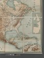
English: * Relief shown by shading and gradient tints.
|
||
| Title | H. Kiepert's physikalische Wandkarten | ||
| Alternative title | Nord-America im Massstabe von 1: 8,000,000 | ||
| Date | |||
| Source | https://digitalcollections.nypl.org/items/e008f040-2350-0133-2972-58d385a7b928 | ||
| Author | Scan by NYPL | ||
| Permission (Reusing this file) |
|
||
| Other versions |
|
||
| UUID | 21aad860-2350-0133-6e5e-58d385a7b928 | ||
| MODS | http://api.repo.nypl.org/api/v1/items/mods/e008f040-2350-0133-2972-58d385a7b928 | ||
| Origin place | Verlag von Dietrich Reimer | ||
| Image ID | 5437637 | ||
| Collection | Maps of North America | ||
| Collection UUID | e008f040-2350-0133-2972-58d385a7b928 | ||
| NYPL catalog ID | b20762154 | ||
| Topics | Physical geography |
.jpg)
.jpg)
.jpg)


.jpg)

.jpg&action=edit§ion=1)
Licensing[edit]
.jpg&action=edit§ion=2)
This image is in the public domain because it is a mere mechanical scan or photocopy of a public domain original, or – from the available evidence – is so similar to such a scan or photocopy that no copyright protection can be expected to arise. The original itself is in the public domain for the following reason:
This tag is designed for use where there may be a need to assert that any enhancements (eg brightness, contrast, colour-matching, sharpening) are in themselves insufficiently creative to generate a new copyright. It can be used where it is unknown whether any enhancements have been made, as well as when the enhancements are clear but insufficient. For known raw unenhanced scans you can use an appropriate {{PD-old}} tag instead. For usage, see Commons:When to use the PD-scan tag.  |
File history
Click on a date/time to view the file as it appeared at that time.
| Date/Time | Thumbnail | Dimensions | User | Comment | |
|---|---|---|---|---|---|
| current | 21:58, 12 July 2016 | | 7,610 × 9,757 (68.06 MB) | Fæ (talk | contribs) | Maps of North America collection http://digitalcollections.nypl.org/items/e008f040-2350-0133-2972-58d385a7b928, part of User:Fæ/Project list/NYPL J92.211 |
You cannot overwrite this file.
File usage on Commons
The following 9 pages use this file:
- File:H. Kiepert's physikalische Wandkarten (NYPL b20762154-5437637).tiff
- File:H. Kiepert's physikalische Wandkarten (NYPL b20762154-5437638).jpg
- File:H. Kiepert's physikalische Wandkarten (NYPL b20762154-5437638).tiff
- File:H. Kiepert's physikalische Wandkarten (NYPL b20762154-5437639).jpg
- File:H. Kiepert's physikalische Wandkarten (NYPL b20762154-5437639).tiff
- File:H. Kiepert's physikalische Wandkarten (NYPL b20762154-5437640).jpg
- File:H. Kiepert's physikalische Wandkarten (NYPL b20762154-5437640).tiff
- File:H. Kiepert's physikalische Wandkarten (NYPL b20762154-5437641).jpg
- File:H. Kiepert's physikalische Wandkarten (NYPL b20762154-5437641).tiff
.jpg&oldid=452885461)