File:Hesperia Topo Map.jpg
Jump to navigation
Jump to search

Size of this preview: 736 × 600 pixels. Other resolutions: 295 × 240 pixels | 589 × 480 pixels | 943 × 768 pixels | 1,025 × 835 pixels.
Original file (1,025 × 835 pixels, file size: 295 KB, MIME type: image/jpeg)
Captions
Captions
Add a one-line explanation of what this file represents
Summary[edit]
| Description |
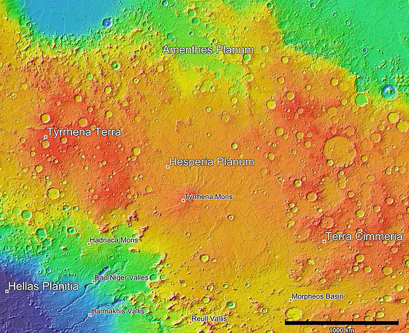
English: MOLA colorized topographic map of Hesperia Planum |
| Date | (UTC) |
| Source | JMARS: http://jmars.asu.edu/ |
| Author | NASA/Arizona State University |
| Permission (Reusing this file) |
Open Source: http://jmars.asu.edu/opensource |
Licensing[edit]

|
Permission is granted to copy, distribute and/or modify this document under the terms of the GNU Free Documentation License, Version 1.2 or any later version published by the Free Software Foundation; with no Invariant Sections, no Front-Cover Texts, and no Back-Cover Texts. A copy of the license is included in the section entitled GNU Free Documentation License. |
Original upload log[edit]
Transferred from en.wikipedia to Commons using For the Common Good.
The original description page was here. All following user names refer to en.wikipedia.
| Date/Time | Dimensions | User | Comment |
|---|---|---|---|
| 19:57, 28 July 2011 | 1,025 × 835 (301,954 bytes) | w:en:Schaffman (talk | contribs) | {{Information |Description = MOLA colorized topographic map of Hesperia Planum |Source = JMARS: http://jmars.asu.edu/ |Date = ~~~~~ |Author = NASA/Arizona State University |Permission = Open Source: http://jmars.asu.e |
File history
Click on a date/time to view the file as it appeared at that time.
| Date/Time | Thumbnail | Dimensions | User | Comment | |
|---|---|---|---|---|---|
| current | 09:06, 13 March 2014 | | 1,025 × 835 (295 KB) | MarsPF2 (talk | contribs) | Transferred from en.wikipedia: see original upload log above |
You cannot overwrite this file.
File usage on Commons
The following page uses this file:
File usage on other wikis
The following other wikis use this file:
- Usage on ca.wikipedia.org
- Usage on en.wikipedia.org
- Usage on es.wikipedia.org
- Usage on fr.wikipedia.org
- Usage on it.wikipedia.org
- Usage on nn.wikipedia.org
- Usage on uk.wikipedia.org
- Usage on www.wikidata.org
- Usage on zh.wikipedia.org