File:Hohe Acht im linksrheinischen Teilgebirge.jpg
Jump to navigation
Jump to search

Size of this preview: 800 × 530 pixels. Other resolutions: 320 × 212 pixels | 640 × 424 pixels | 1,024 × 679 pixels | 1,317 × 873 pixels.
Original file (1,317 × 873 pixels, file size: 1 MB, MIME type: image/jpeg)
Captions
Captions
Add a one-line explanation of what this file represents
Summary[edit]
| Description |
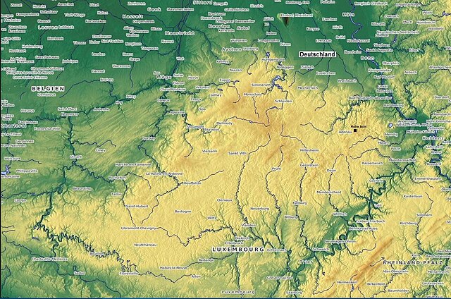
Deutsch: Hohe Acht im linksrheinischen Teilgebirge des Rheinischen Schiefergebirges .Morphologisch zusammenhängendes Bergland von Ardennen und Eifel, eingerahmt von den Flüssen Semois, Maas, Mosel und Rhein. Höchste Erhebung ist die Hohe Acht mit 746,9 m ü. NHN |
| Date | |
| Source | http://www.maps-for-free.com/ |
| Author | L.1951a |
Licensing[edit]
This file is licensed under the Creative Commons Attribution-Share Alike 3.0 Unported license.
- You are free:
- to share – to copy, distribute and transmit the work
- to remix – to adapt the work
- Under the following conditions:
- attribution – You must give appropriate credit, provide a link to the license, and indicate if changes were made. You may do so in any reasonable manner, but not in any way that suggests the licensor endorses you or your use.
- share alike – If you remix, transform, or build upon the material, you must distribute your contributions under the same or compatible license as the original.
File history
Click on a date/time to view the file as it appeared at that time.
| Date/Time | Thumbnail | Dimensions | User | Comment | |
|---|---|---|---|---|---|
| current | 10:43, 29 April 2020 | | 1,317 × 873 (1 MB) | Albert Gr. (talk | contribs) | Uploaded a work by L.1951a from http://www.maps-for-free.com/ with UploadWizard |
You cannot overwrite this file.
File usage on Commons
The following 2 pages use this file:
File usage on other wikis
The following other wikis use this file:
- Usage on de.wikipedia.org
- Usage on en.wikipedia.org
- Usage on nl.wikipedia.org