File:Hurricane Earl 2010-09-02 1529Z.jpg
Original file (6,000 × 7,800 pixels, file size: 5.75 MB, MIME type: image/jpeg)
Captions
Captions
Summary[edit]
| Description |
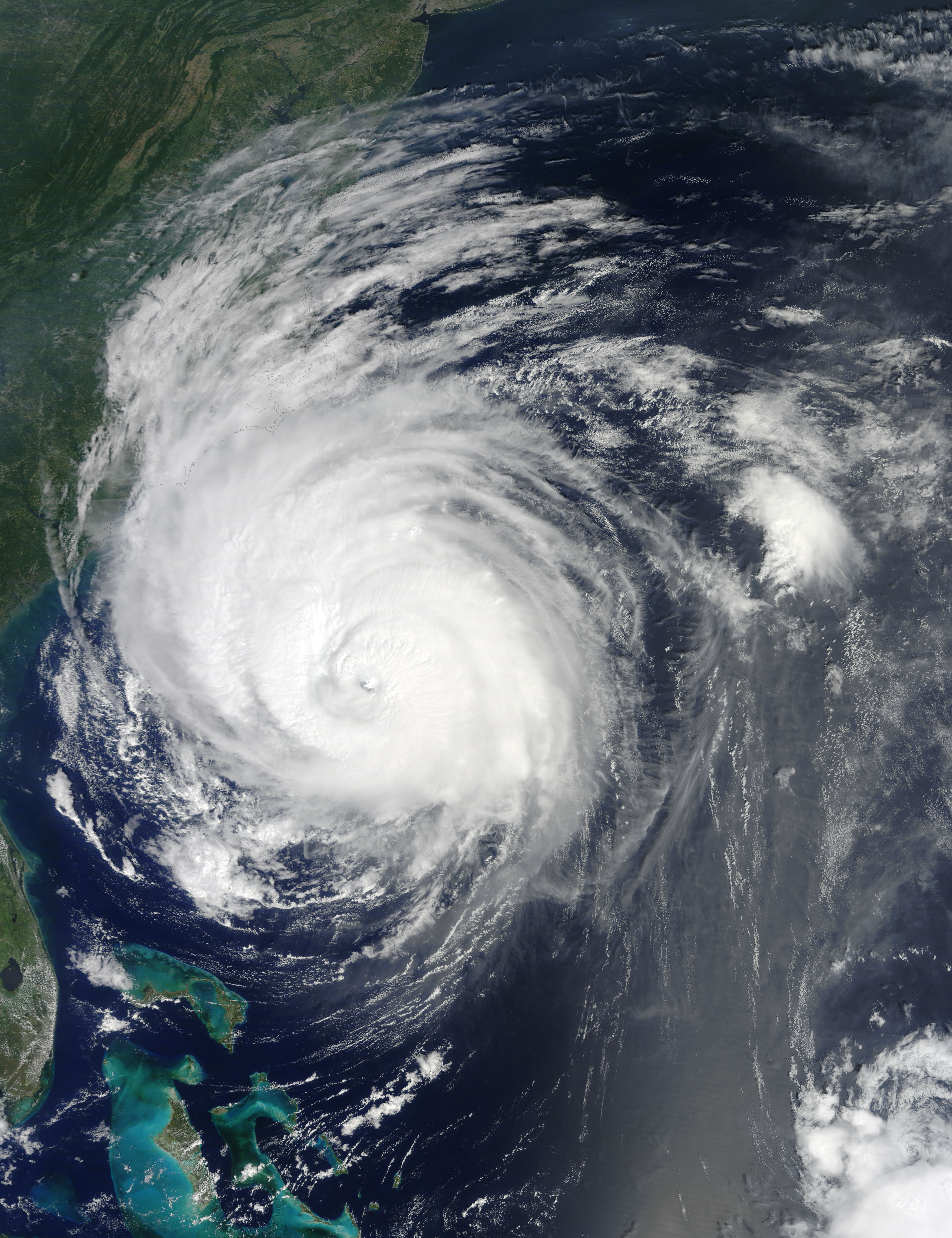
English: Hurricane Earl the southeastern United States.
NASA image acquired September 2, 2010 At 2:00 p.m. Eastern Daylight Time (EDT) on September 2, 2010, the U.S. National Hurricane Center (NHC) reported that Hurricane Earl was roughly 245 miles (395 kilometers) south of Cape Hatteras, North Carolina, and about 720 miles (1,155 kilometers) south-southwest of Nantucket, Massachusetts. A Category 3 hurricane, Earl packed maximum sustained winds of 125 miles (205 kilometers) per hour. The NHC warned that Earl was expected to pass near North Carolina's Outer Banks overnight. The Moderate Resolution Imaging Spectroradiometer (MODIS) on NASA’s Terra satellite captured this natural-color image of Hurricane Earl grazing the North Carolina coast at 11:29 a.m. EDT (15:29 UTC) on September 2. Earl shows visible characteristics of a powerful hurricane—large size, spiral arms, and a distinct eye. Clouds from Earl extend primarily over North Carolina and Virginia. The NHC issued multiple hurricane watches and warnings, including a hurricane warning from Bogue Inlet, North Carolina, northeastward to the Virginia border; and from Westport, Massachusetts, around Cape Cod to Hull. The NHC also warned that a powerful storm surge could raise water levels by 3 to 5 feet (1 to 1.5 meters) in some places. (Please see the NHC’s advisory archive for more information.) The NHC forecast that Earl would turn toward the north-northeast and pick up speed on September 3. Even though the storm had begun to weaken, it was expected to remain a powerful hurricane as it passed the Outer Banks. Researchers participating in the Genesis and Rapid Intensification Processes (GRIP) mission flew NASA’s DC-8 and WB-57 planes and the robotic Global Hawk aircraft through and over Hurricane Earl on September 2 as the storm approached the Carolina coast. During flights earlier in the week, researchers noticed that dry air surrounded Earl. Hurricanes usually derive energy from moist air, and dry air can weaken or even stop a storm. “The scientific question is: will Earl maintain its intensity in the face of all this dry air?” said Ed Zipser, researcher from the University of Utah. “Is that dry air getting in? And if it is, is it going to kill the storm?” NASA image courtesy Jeff Schmaltz, MODIS Rapid Response Team at NASA GSFC using data courtesy of the University of South Florida. Caption by Michon Scott. Instrument: Terra - MODIS NASA Goddard Space Flight Center is home to the nation's largest organization of combined scientists, engineers and technologists that build spacecraft, instruments and new technology to study the Earth, the sun, our solar system, and the universe. Follow us on Twitter Join us on Facebook To view more images go to: earthobservatory.nasa.gov/NaturalHazards/event.php?id=45530 |
| Date | |
| Source | |
| Author | NASA Goddard Space Flight Center from Greenbelt, MD, USA NASA Terra/MODIS |
Licensing[edit]
| This file is in the public domain in the United States because it was solely created by NASA. NASA copyright policy states that "NASA material is not protected by copyright unless noted". (See Template:PD-USGov, NASA copyright policy page or JPL Image Use Policy.) | ||
 |
Warnings:
|
- You are free:
- to share – to copy, distribute and transmit the work
- to remix – to adapt the work
- Under the following conditions:
- attribution – You must give appropriate credit, provide a link to the license, and indicate if changes were made. You may do so in any reasonable manner, but not in any way that suggests the licensor endorses you or your use.
| This image was originally posted to Flickr by NASA Goddard Photo and Video at https://flickr.com/photos/24662369@N07/4954583979. It was reviewed on 6 October 2017 by FlickreviewR and was confirmed to be licensed under the terms of the cc-by-2.0. |
File history
Click on a date/time to view the file as it appeared at that time.
| Date/Time | Thumbnail | Dimensions | User | Comment | |
|---|---|---|---|---|---|
| current | 19:23, 2 September 2010 | | 6,000 × 7,800 (5.75 MB) | HurricaneSpin (talk | contribs) | {{Information |Description={{en|1=Hurricane Earl the southeastern United States.}} |Source=http://rapidfire.sci.gsfc.nasa.gov/gallery/?2010245-0902/Earl.A2010245.1529.2km.jpg |Author=NASA Terra/MODIS |Date=2010-09-02 |Permission=See below |other_versions= |
You cannot overwrite this file.
File usage on Commons
The following 2 pages use this file:
.jpg&redirect=no)
File usage on other wikis
The following other wikis use this file:
- Usage on en.wikinews.org