File:Hurricane Three surface analysis 4 Sept 1917.jpg
Jump to navigation
Jump to search

Size of this preview: 647 × 599 pixels. Other resolutions: 259 × 240 pixels | 518 × 480 pixels | 720 × 667 pixels.
Original file (720 × 667 pixels, file size: 95 KB, MIME type: image/jpeg)
Captions
Captions
Add a one-line explanation of what this file represents
Summary[edit]
| Description |
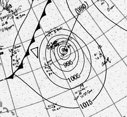
English: Hurricane Three at its peak intensity on September 4, 1917 out in the Atlantic Ocean. |
| Date | |
| Source | http://www.aoml.noaa.gov/hrd/hurdat/weathermaps/ |
| Author | Atlantic Oceanographic and Meteorological Laboratory, National Oceanic and Atmospheric Administration |
Licensing[edit]
This image is in the public domain because it contains materials that originally came from the U.S. National Oceanic and Atmospheric Administration, taken or made as part of an employee's official duties.
|
File history
Click on a date/time to view the file as it appeared at that time.
| Date/Time | Thumbnail | Dimensions | User | Comment | |
|---|---|---|---|---|---|
| current | 02:07, 13 July 2014 | | 720 × 667 (95 KB) | TheAustinMan (talk | contribs) | User created page with UploadWizard |
You cannot overwrite this file.
File usage on Commons
There are no pages that use this file.
File usage on other wikis
The following other wikis use this file:
- Usage on en.wikipedia.org
- Usage on zh.wikipedia.org