File:ISS viewed by TerraSAR-X.jpg
Jump to navigation
Jump to search

Size of this preview: 600 × 600 pixels. Other resolutions: 240 × 240 pixels | 480 × 480 pixels | 768 × 768 pixels | 1,216 × 1,216 pixels.
Original file (1,216 × 1,216 pixels, file size: 395 KB, MIME type: image/jpeg)
Captions
Captions
Add a one-line explanation of what this file represents
Summary[edit]
| Description |
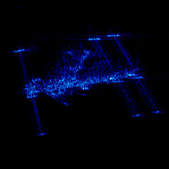
Polski: Międzynarodowa Stacja Kosmiczna ISS zobrazowana 13 marca 2008 przez radar niemieckiego satelity TerraSAR-X.
Satelity minęły się w odległości 195 km ze względną prędkością 34540 km/h. Obraz ma rozdzielczość ok. 1 m i z uwagi na użycie radaru, charakteryzuje się tym, że przedstawia głównie krawędzie a nie płaszczyzny.English: On 13 March 2008, the International Space Station (ISS) passed across the field-of-view of Germany's remote sensing satellite, TerraSAR-X, at a distance of 195 kilometres (122 miles) and at a relative speed of 34,540 kilometres per hour (or over 22,000 mph).
In contrast to optical cameras, radar does not ‘see’ surfaces. Instead, it is much more aware of the edges and corners which bounce back the microwave signal it transmits. Smooth surfaces such as those on the ISS solar generators or the radiator panels used to dissipate excess heat, unless directly facing the radar antenna, tend to deflect rather than reflect the radar beam, causing these features to appear on the radar image as dark areas. The radar image of the ISS therefore looks like a dense collection of bright spots from which the outlines of the space station can be clearly identified. The central element on the ISS, to which all the modules are docked, has a grid structure that presents a multiplicity of reflecting surfaces to the radar beam, making it readily identifiable. This image has a resolution of about one metre. In other words, objects can be depicted as discrete units – that is, shown separately – provided that they are at least one metre apart. If they are closer together than that, they tend to merge into a single block on a radar image. |
| Date | |
| Source | http://www.dlr.de/media/en/desktopdefault.aspx/tabid-4986/8423_read-13563/8423_page-2 |
| Author | DLF |
Licensing[edit]
This file is licensed under the Creative Commons Attribution 3.0 Unported license.
- You are free:
- to share – to copy, distribute and transmit the work
- to remix – to adapt the work
- Under the following conditions:
- attribution – You must give appropriate credit, provide a link to the license, and indicate if changes were made. You may do so in any reasonable manner, but not in any way that suggests the licensor endorses you or your use.
File history
Click on a date/time to view the file as it appeared at that time.
| Date/Time | Thumbnail | Dimensions | User | Comment | |
|---|---|---|---|---|---|
| current | 22:06, 6 June 2014 | | 1,216 × 1,216 (395 KB) | NH2501 (talk | contribs) | User created page with UploadWizard |
You cannot overwrite this file.
File usage on Commons
The following page uses this file: